
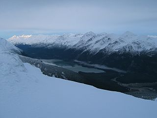
The Brooks Range is a mountain range in far northern North America stretching some 700 miles (1,100 km) from west to east across northern Alaska into Canada's Yukon Territory. Reaching a peak elevation of 8,976 feet (2,736 m) on Mount Isto, the range is believed to be approximately 126 million years old.

The Alaska North Slope is the region of the U.S. state of Alaska located on the northern slope of the Brooks Range along the coast of two marginal seas of the Arctic Ocean, the Chukchi Sea being on the western side of Point Barrow, and the Beaufort Sea on the eastern.

Iliamna Lake or Lake Iliamna is a lake in southwest Alaska, at the north end of the Alaska Peninsula, between Kvichak Bay and Cook Inlet, about 100 miles (160 km) west of Seldovia, Alaska.

White Deer Hole Creek is a 20.5-mile (33.0 km) tributary of the West Branch Susquehanna River in Clinton, Lycoming and Union counties in the U.S. state of Pennsylvania. A part of the Chesapeake Bay drainage basin, the White Deer Hole Creek watershed drains parts of ten townships. The creek flows east in a valley of the Ridge-and-valley Appalachians, through sandstone, limestone, and shale from the Ordovician, Silurian, and Devonian periods.
The Chilkoot Lake, in the Tlingit Indians region of Alaska, is also spelt Chilcoot Lake. Its other local names are the Akha Lake and Tschilkut S(ee), meaning "Chilkoot Lake". It is in Haines Borough, Alaska. Chilkoot also means "big fish". The lake has a ‘Recreation Site’ at its southern end near the outlet to the Chilkoot River, which is set amidst the Sitka spruce trees. Chilkoot River flows from the lake for a short length and debouches into the Lutak Channel at the head of the Chilkoot inlet near Haines. Chilkoot village, a settlement of Chilkoot Indians existed at the outlet of the lake, which was called Tschilkut or Tananel or Chilcoot; the lake is named after this village. This village is now a camping area developed by the State Parks and Outdoor Recreation Division of the Alaska Department of Natural Resources. The lake is a popular location for Kayaking.

The Chakachatna River is a stream, 36 miles (58 km) long, in northwestern Kenai Peninsula Borough in the U.S. state of Alaska. It flows from Chakachamna Lake southeastward into the McArthur River, which flows into the Gompertz Channel of Cook Inlet. The river mouth is about 3 miles (5 km) north of Trading Bay and 32 miles (51 km) northwest of Kenai.
The Kuparuk River is a river in Alaska's North Slope that enters a bay on the Beaufort Sea between Beechey Point and Prudhoe Bay. The north-flowing river is about 200 miles (320 km) long, and its delta is about 3 miles (5 km) wide. Its Eskimo name appeared on a map drawn in 1901 by a prospector who spelled it Koopowra, which he translated as Big River. Kuukpaaġruk can be translated to a "smaller version of a big river".
The Sagavanirktok River or Sag River is a stream in the North Slope Borough of the U.S. state of Alaska. It is about 180 miles (290 km) long and originates on the north slope of the Brooks Range, flowing north to the Beaufort Sea near Prudhoe Bay. The Trans-Alaska Pipeline System and Dalton Highway roughly parallel it from Atigun Pass to Deadhorse.
The Tikchik River is a 45 miles (72 km) long stream in the U.S. state of Alaska. Beginning at Nishlik Lake in the Kuskokwim Mountains, it flows southeast into Tikchik Lake, 65 miles (105 km) north of Dillingham. Tikchik Lake empties into the Nuyakuk River, a tributary of the Nushagak River, which flows to Nushagak Bay, an arm of Bristol Bay.
Conewago Creek is a 23.0-mile-long (37.0 km) tributary of the Susquehanna River in Lebanon, Dauphin, and Lancaster counties in Pennsylvania in the United States. The source is at an elevation of 1,100 feet (340 m) at Mount Gretna Heights in Lebanon County. The mouth is the confluence with the Susquehanna River at an elevation of 261 feet (80 m) at the border of Dauphin and Lancaster counties, just south of Three Mile Island in the river and just north of the unincorporated village of Falmouth in Conoy Township, Lancaster County.

The Fish River is a waterway in the U.S. state of Alaska. The 47-mile-long (76 km) river rises in the Bendeleben Mountains and flows south to Golovnin Lagoon, before emptying into Golovnin Bay, Norton Sound, and the Bering Sea. The basin formed by the Fish River is known for its placer gold deposits, and in particular, the Niukluk River and its tributaries; production from this tributary valley is reported to be more than from any other place in the region. A galena mine existed 40 miles (64 km) from the sea, worked on occasion by a San Francisco corporation with a few hundred tons of ore taken to the city for smelting and refining for silver. Walter Curran Mendenhall found obscure fossils on Fish River at White Mountain.

The Leffingwell Camp Site, on Flaxman Island, 58 miles (93 km) west of Barter Island on the Arctic Coast of Alaska, was used by polar explorer and geologist Ernest de Koven Leffingwell on his pioneering Anglo-American Polar Expedition of 1906–1908, which aimed to explore the Beaufort Sea. The expedition's ship, the Duchess of Bedford, was allowed to become locked in ice which eventually destroyed it.

Ernest de Koven Leffingwell was an arctic explorer, geologist and Spanish–American War veteran.
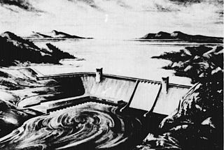
The Rampart Dam or Rampart Canyon Dam was a project proposed in 1954 by the U.S. Army Corps of Engineers to dam the Yukon River in Alaska for hydroelectric power. The project was planned for Rampart Canyon just 31 miles (50 km) southwest of the village of Rampart, Alaska and about 105 miles (169 km) west-northwest of Fairbanks, Alaska.
Thetis Mound is a hill in the North Slope Borough, of Alaska, United States. It is 4 miles (6 km) southeast of Oliktok Point and 13 miles (21 km) west of Beechey Point.

The Rice Fork is a 22.7-mile-long (36.5 km) tributary of the Eel River in Lake County, California. The Rice Fork begins on the upper northwest side of Goat Mountain, on the Colusa-Lake County line, at an elevation of over 6,000 feet (1,800 m). It quickly descends the steep western slope of the mountain, then bends northward, and flows northwesterly down a narrow winding steep walled canyon for about 18 miles (29 km), crossing two forest roads and adding many tributaries, ending its journey at the southern tip of Lake Pillsbury, at a varied elevation around 1,800 feet (550 m), depending on the lake level. Before the construction of Scott Dam in the 1920s, which formed Lake Pillsbury, the Rice Fork ran directly into the Eel River. It is one of Lake County's longest streams.
Kadleroshilik Pingo is a pingo located about 40 kilometers (25 mi) southeast of Prudhoe Bay in the U.S. state of Alaska. Rising to an elevation of 54 meters (178 ft) above the surrounding lake plain, it is the highest known pingo in the world.
The Joshua Green River is a stream, 15 miles (24 km) long, in the Aleutians East Borough of the U.S. state of Alaska. It flows generally northwest across the Izembek National Wildlife Refuge from its source in the Aleutian Range of the Alaska Peninsula into Moffet Lagoon, Bristol Bay, on the Bering Sea. The river's mouth is 17 miles (27 km) northeast of Cold Bay.
The Ipnavik River is a 68-mile-long (109 km) tributary of the Colville River in the Alaska North Slope which was part of the traditional lands of the Iñupiat, who named it "Ipnavak" which means "place where young Dall sheep grow up" with its headwaters in the Brooks Range. The Ipnavik River flows northeast to meet the Colville River 50 miles (80 km). It flows north northeast of Howard Pass, which is the mouth of the Ipnavik. The name was documented by the United States Geological Survey in 1925.
