Haida are a nation and ethnic group native to, or otherwise associated with, Haida Gwaii meaning "Coming out of concealment" or sometimes "island of the People", and the Haida language. The Haida language is an isolate language, that has been spoken historically across Haida Gwaii and other islands on the Alaska Panhandle. To this day, 445 people still claim to speak the Haida language. Prior to the 19th century, Haida spoke a number of coastal First Nations languages such as Tlingit, Nisg̱a'a and Coast Tsimshian. Throughout the Northwest Coast, indigenous nations spoke a minimum of 45 languages. When Haida moved to Alaska in the eighteenth century they also spoke the Masset dialect. The Haida language was ruthlessly driven out of kidnapped Haida children through the Canadian residential school system. This resulted in a sudden decline in its usage throughout the 1900s. Haida language champions are working through multiple initiatives to revitalize the Haida language along with Haida law, customs, and cultural identity.

Kasaan is a city in the Prince of Wales-Hyder Census Area in the U.S. state of Alaska. The population was 49 at the 2010 census, up from 39 in 2000. The name "Kasaan" comes from Tlingit kasa'aan, meaning "pretty town".

The Alexander Archipelago is a 300-mile (480 km) long archipelago, or group of islands, of North America off the southeastern coast of Alaska. It contains about 1,100 islands, which are the tops of the submerged coastal mountains that rise steeply from the Pacific Ocean. Deep channels and fjords separate the islands and cut them off from the mainland. The northern part of the Inside Passage is sheltered by the islands as it winds its way among them.

The Dixon Entrance is a strait about 80 kilometers (50 mi) long and wide in the Pacific Ocean at the Canada–United States border, between the U.S. state of Alaska and the province of British Columbia in Canada. It was named by Joseph Banks for Captain George Dixon, a Royal Navy officer, fur trader, and explorer, who surveyed the area in 1787. The Dixon Entrance is part of the Inside Passage shipping route. It forms part of the maritime boundary between the U.S. and Canada, although the location of that boundary here is disputed. A name used in the Haida language is Seegaay, which means only "ocean".

Dall Island is an island in the Alexander Archipelago off the southeast coast of Alaska, just west of Prince of Wales Island and north of Canadian waters. Its peak elevation is 2,443 feet above sea level. Its land area is 254.0 square miles (657.9 km2), making it the 28th largest island in the United States. Dall is used economically for fishing and limestone quarrying.
Long Island is an island in the Alexander Archipelago of southeastern Alaska, United States. It lies across the Kaigani Strait from the southern portion of Dall Island and west of the southern part of Prince of Wales Island. Directly to its north is Sukkwan Island. Long Island forms part of the western boundary of Cordova Bay, and has a land area of 116.136 km² and was unpopulated at the 2000 census.
Joseph Ingraham (1762–1800) was an American sailor and maritime fur trader who discovered several islands of the Marquesas Islands while on his way to trade along the west coast of North America. He was also a prisoner in the American Revolutionary War and an officer in the United States Navy.
Resolution was a small American schooner, built in the Marquesas Islands in 1793 as a tender for the maritime fur trade ship Jefferson. Later in 1793 she arrived at the Columbia River, becoming the fourth European vessel to enter the river. Cruised between the Columbia River and Clayoquot Sound. In March 1794 the Resolution separated from the Jefferson. After several brief voyages she was captured and destroyed by Haida chief Cumshewa and his followers in 1794. All the crew but one were killed. The lone survivor was later rescued by the Boston ship Despatch.
Fort Simpson was a fur trading post established in 1831 by the Hudson's Bay Company (HBC) near the mouth of the Nass River in present-day British Columbia, Canada. In 1834, it was moved to the Tsimpsean Peninsula, about halfway between the Nass River and the Skeena River, and was later referred to as Port Simpson or as the native name Lax Kw'alaams. The fort was part of the HBC's Columbia Department.
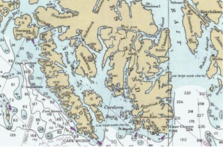
Cape Muzon is a cape located in the Alexander Archipelago of the U.S. state of Alaska. It is the southernmost point of Dall Island and the headland marking the northwestern extremity of the Dixon Entrance. The boundary line separating Alaska from Canada runs very close to Cape Muzon, although according to the Alaska Boundary Treaty Cape Muzon is defined precisely as the western end of the so-called A-B Line, part of the Canada–United States border.

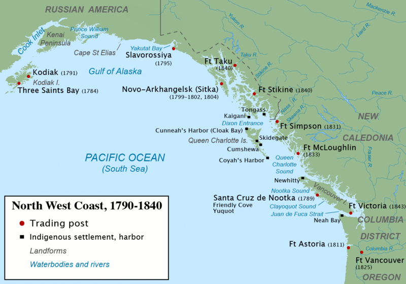
The maritime fur trade was a ship-based fur trade system that focused on acquiring furs of sea otters and other animals from the indigenous peoples of the Pacific Northwest Coast and natives of Alaska. The furs were mostly sold in China in exchange for tea, silks, porcelain, and other Chinese goods, which were then sold in Europe and the United States. The maritime fur trade was pioneered by Russians, working east from Kamchatka along the Aleutian Islands to the southern coast of Alaska. British and Americans entered during the 1780s, focusing on what is now the coast of British Columbia. The trade boomed around the beginning of the 19th century. A long period of decline began in the 1810s. As the sea otter population was depleted, the maritime fur trade diversified and transformed, tapping new markets and commodities, while continuing to focus on the Northwest Coast and China. It lasted until the middle to late 19th century. Russians controlled most of the coast of what is now Alaska during the entire era. The coast south of Alaska endured fierce competition between, and among, British and American trading vessels. The British were the first to operate in the southern sector, but were unable to compete against the Americans, who dominated from the 1790s to the 1830s. The British Hudson's Bay Company entered the coast trade in the 1820s with the intention of driving the Americans away. This was accomplished by about 1840. In its late period, the maritime fur trade was largely conducted by the British Hudson's Bay Company and the Russian-American Company.

Cordova Bay is a bay in the Alexander Archipelago of southeast Alaska. It opens onto Dixon Entrance to the south, between Cape Muzon on Dall Island and Point Marsh. The name Puerto Cordova y Cordova was given by the Spanish explorer Lieutenant Don Jacinto Caamaño in 1792, in honor of Admiral Luis de Córdova y Córdova. The name was published by George Vancouver in 1798.
William Douglas was a Scottish ship captain and an oceanographer maritime fur trader during the late 18th century. He worked with the British trader and Captain John Meares, commanding the ship Iphigenia Nubiana. He was involved in the Nootka Crisis of 1789, which brought Britain and Spain to the brink of war. A few years later he was captain of the American ship Grace. In 1791 he partnered with Captain John Kendrick in an attempt to open trade with Japan.
American Bay is a waterway in the U.S. state of Alaska. It is located on the east side of Dall Island, facing Long Island across Kaigani Strait.
Kiusta located on Haida Gwaii is the oldest Northern Haida village: and the site of first recorded contact between the Haida and Europeans in 1774. Haida lived in this village for thousands of years, due to the sheltered nature of its location it was used for boats offloading, especially in rough waters. Kiusta is one of the oldest archeological sites of human use in British Columbia, and continues to be a site for cultural revitalisation.

Cuneah, also Gunia, Cunneah, Cunnyha, Cunniah, Coneehaw, Connehaw, Cunneaw (Haida: Gəniyá, was the chief of Kiusta, a town at the northwestern tip of Graham Island during the era of the Maritime Fur Trade in Haida Gwaii off the North Coast of British Columbia, Canada. This town was an important port of call for acquiring sea otter skins in the early years of the maritime fur trade. Cuneah seems to have avoided the violence that plagued other Haida chiefs, like Koyah.
Union was an American sloop built in Somerset, Massachusetts in 1792. It is best known for its circumnavigation of the world, 1794–1796, under the maritime fur trader John Boit.
Cholmondeley Sound is a deep bay or inlet on the southeast side of Prince of Wales Island, in the Alexander Archipelago of southeast Alaska, in Tongass National Forest and connecting to Clarence Strait. The sound's entrance lies between Chasina Point and Skin Island. It is about 20 miles (32 km) west of Ketchikan, Alaska. Cholmondeley Sound has several bays and inlets within it, including Kitkun Bay, Dora Bay, Brennan Bay, and Sunny Cove. At its western end Cholmondeley Sound splits into two fjord-like inlets: West Arm Chomondeley Sound, about 7.5 miles (12.1 km) long,, and South Arm Cholmondeley Sound, about 8 miles (13 km) long. The full length from the entrance of the sound to the head of West Arm is about 16 miles (26 km).
Cloak Bay is a bay in Haida Gwaii, British Columbia, Canada. It is located on the west side of Langara Island, between Langara and Graham Island, at the northwestern end of Haida Gwaii. It adjoins Parry Passage, the strait between Langara and Graham Island. There are several islands in Cloak Bay, the largest being Cox Island. Indian Reserves on or near Cloak Bay include Guoyskun 22, on the north side of Cloak Bay, and Kioosta 15, on Parry Passage. The historic Haida village of Kiusta is the main settlement in the area.
John Boit Jr was one of the first Americans involved in the maritime fur trade. He sailed as fifth mate under Captain Robert Gray on the second voygage of the Columbia Rediviva, 1790–1793. During the voyage he wrote a short but important journal in which he described the discovery of the Columbia River.