Kaitorete Spit

Last updated

Kaitorete Spit
Aerial view Kaitorete Spit.jpg
Kaitorete Spit separating Lake Ellesmere / Te Waihora from the Canterbury Bight
Offshore water bodies Lake Ellesmere / Te Waihora
Age 6,000–8,000 years
Formed bygravel outwash
Dimensions
  Length27 km
  Widthfrom 200 m to 3.2 km
Highest elevation20 m

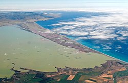
Kaitorete Spit is a long finger of land which extends along the coast of Canterbury in the South Island of New Zealand. It runs west from Banks Peninsula for 25 kilometres, and separates the shallow Lake Ellesmere / Te Waihora from the Pacific Ocean. It is technically a continuous barrier beach, though at its western end it tapers to a point less than 100 metres in width which is occasionally breached at high tide. The spit is noted for its isolation and for its pebbly beaches. At its eastern end is the small settlement of Birdlings Flat, and west of its narrowest point is the settlement of Taumutu.

Contents

Geography

Kaitorete Spit to the south of Lake Ellesmere / Te Waihora, with Christchurch and Lyttelton Harbour to the north Christchurch and Waihora, 2001, Landsat 7 ETM (cropped).jpg
Kaitorete Spit to the south of Lake Ellesmere / Te Waihora, with Christchurch and Lyttelton Harbour to the north

Kaitorete is low-lying but is not prone to flooding. A gravel road extends along half of its length from the small settlement of Birdlings Flat at its easternmost point. At this point, the northern shore of the spit is washed by a tidal lagoon, Kaituna Lagoon, which is essentially a short broad arm of Lake Ellesmere. It is also at its point that the spit is at its widest – some 3.5 kilometres. SH 75 skirts the hills of Banks Peninsula close to the spit's eastern end. [1]

Although usually referred to as a spit, Kaitorete is technically a barrier beach. A spit is widest at the updrift end and tapers to a narrow tip at the downdrift end, but Kaitorete is narrower at the southernmost (updrift) end and widest at the northernmost (downdrift) end. Unlike a spit, it is attached to land at both ends (although somewhat tenuously at its westernmost extremity).

Origin

At the end of the Last Glacial Maximum 20,000 years ago valley glaciers had advanced in Canterbury and glacial outwash rivers delivered vast quantities of sand, gravel, and silt to the coast. The sea level at that time was 130 meters lower than today, and the coast was up to 50 km east of its present-day position; the Canterbury plains were twice their present width. Melting glaciers led to rapid sea level rise which drowned what is now the continental shelf, and shifted the coastline rapidly westward, swallowing the seaward edge of the plains. Ten thousand years ago the Canterbury coastline was approaching the area presently occupied by Lake Ellesmere / Te Waihora. Then, as now, the coast was made of unconsolidated sands and gravels from the fans of major rivers such as the Rakaia and Waimakariri. Powerful southerly waves in the Canterbury Bight rapidly eroded these weakly-resistant sands and gravels, and transported them northwards by longshore drift. This massive supply of sea-borne sediments moving towards Banks Peninsula combined with direct river-borne sediment to create the Kaitorete barrier and enclose what became Lake Ellesmere / Te Waihora.

Ecology

The barrier is of considerable ecological significance and is home to the majority of the surviving specimens of shrubby tororaro (Muehlenbeckia astonii) – a nationally endangered endemic plant. The Kaitorete Spit dune habitat also contains a distinctive moth fauna with naturally rare species. [2] Several species of moth are endemic to Kaitorete Spit including Kiwaia jeanae , Scythris niphozela and Kupea electilis . [2]

Rocketry

In July 2015, aerospace company Rocket Lab announced that it would use Kaitorete Spit as their New Zealand satellite launch site. When the resource consent allowed them only twelve rocket launches per year the company went to Māhia Peninsula in the North Island instead. [3] Kaitorete Spit had previously, in the 1960s, been used by NASA for rocket launches. [4]

Related Research Articles

<span class="mw-page-title-main">Longshore drift</span> Sediment moved by the longshore current

Longshore drift from longshore current is a geological process that consists of the transportation of sediments along a coast parallel to the shoreline, which is dependent on the angle of incoming wave direction. Oblique incoming wind squeezes water along the coast, and so generates a water current which moves parallel to the coast. Longshore drift is simply the sediment moved by the longshore current. This current and sediment movement occur within the surf zone. The process is also known as littoral drift.

<span class="mw-page-title-main">Lake Ellesmere / Te Waihora</span> Lagoon in New Zealand

Lake Ellesmere / Te Waihora is a broad, shallow coastal lake or waituna, in the Canterbury region of the South Island of New Zealand. It is directly to the west of Banks Peninsula, separated from the Pacific Ocean by the long, narrow, sandy Kaitorete Spit, or more correctly Kaitorete Barrier. It lies partially in extreme southeastern Selwyn District and partially in the southwestern extension of the former Banks Peninsula District, which now is a ward in the city of Christchurch. The lake holds high historical and cultural significance to the indigenous Māori population and the traditional Māori name Te Waihora, means spreading waters. It has officially had a dual English/Māori name since at least 1938.

<span class="mw-page-title-main">Selwyn River</span> River in New Zealand

The Selwyn River flows through the Selwyn District of Canterbury in the South Island of New Zealand.

<span class="mw-page-title-main">Birdlings Flat</span> Town in Canterbury, New Zealand

{{Infobox settlement

 | name = Birdlings Flat

Akaroa was a New Zealand electorate. It was located in Banks Peninsula, Canterbury, and named after the town of the same name. One of the original 24 electorates, it existed from 1853 to 1893.

<i>Muehlenbeckia astonii</i> Species of shrub

Muehlenbeckia astonii or shrubby tororaro is an endemic New Zealand shrub in the family Polygonaceae. It has distinctive small heart-shaped deciduous leaves amidst a tangle of wiry interlocking branches. Although common in cultivation around the world, it is extremely rare and threatened in the wild.

Washdyke Lagoon is a brackish shallow coastal lagoon approximately 1 kilometre (0.62 mi) north of Timaru, South Canterbury, New Zealand. The lagoon has drastically reduced in size since 1881 when it was approximately 253 hectares, now it is less than 48 hectares (0.48 km2) in area. It is enclosed by a barrier beach that is 3 kilometres (1.9 mi) long and 3 metres (9.8 ft) above high tide at its largest point. The reduced lagoon size is due to the construction of the Timaru Port breakwater which is preventing coarse sediments from reaching and replenishing Washdyke Barrier. This is important as the lagoon and the surrounding 250 hectares are classified as a wildlife refuge and it demonstrates the role human structures have on coastline evolution.

<span class="mw-page-title-main">Lake Forsyth</span>

Lake Forsyth is a lake on the south-western side of Banks Peninsula in the Canterbury region of New Zealand, near the eastern end of the much larger Lake Ellesmere / Te Waihora. State Highway 75 to Akaroa and the Little River Rail Trail run along the north-western side of the lake.

<i>Kupea electilis</i> Genus of moths

Kupea is a monotypic moth genus of the family Crambidae described by Alfred Philpott in 1930. It contains only one species, Kupea electilis, also known as Kupe's grassmoth, which is endemic to New Zealand. This species has only been recorded at Kaitorete Spit. The larvae feed on Zoysia minima and exist in a cocoon constructed of silk and sand. Adults are on the wing from March to April. It has been hypothesised that the adults are active at twilight. It is classified as Nationally Vulnerable by the Department of Conservation. The female of the species was first discovered in 2012.

<span class="mw-page-title-main">Halswell River</span> River in New Zealand

The Halswell River is a river in the Canterbury region of New Zealand.

The Irwell River, New Zealand is a river of the Canterbury Plains, in New Zealand's South Island. A short river, it rises to the southeast of Dunsandel, flowing southeast to enter the broad, shallow Lake Ellesmere / Te Waihora.

<span class="mw-page-title-main">L II River</span> River in New Zealand

The L II River is a small spring-fed river in Canterbury, New Zealand. It rises near Lincoln and flows through very flat farmland, mostly fed by land drainage ditches before emptying into Lake Ellesmere / Te Waihora just east of the mouth of the Selwyn River / Waikirikiri.

Ellesmere was a parliamentary electorate in the Canterbury region of New Zealand. It existed for two periods between 1861 and 1928 and was represented by six Members of Parliament.

<span class="mw-page-title-main">Canterbury Bight</span> Oceanic bight in Canterbury, New Zealand

The Canterbury Bight is a large bight on the eastern side of New Zealand's South Island. The bight runs for approximately 135 kilometres (84 mi) from the southern end of Banks Peninsula to the settlement of Timaru and faces southeast, exposing it to high-energy storm waves originating in the Pacific Ocean. The bight is known for rough conditions as a result, with wave heights of over 2 metres (6.6 ft) common. Much of the bight's geography is shaped by this high-energy environment interacting with multiple large rivers which enter the Pacific in the bight, such as the Rakaia, Ashburton / Hakatere, and Rangitata Rivers. Sediment from these rivers, predominantly Greywacke, is deposited along the coast and extends up to 50 kilometres (31 mi) out to sea from the current shoreline. Multiple hapua, or river-mouth lagoons, can be found along the length of the bight where waves have deposited sufficient sediment to form a barrier across a river mouth, including most notably Lake Ellesmere / Te Waihora and Washdyke Lagoon

<span class="mw-page-title-main">State Highway 75 (New Zealand)</span> Road in New Zealand

State Highway 75 (SH 75) is a state highway in New Zealand servicing the Banks Peninsula region, connecting Christchurch on the northwestern part of the peninsula with Akaroa towards the east coast. It is wholly two lane, but partially functions as a major arterial corridor of Christchurch. Its highest point is at Hilltop, where it rises to about 555 m - just 8 m lower than the more mountainous Haast Pass in the Southern Alps.

Kiwaia jeanae, also known as the Kaitorete jumper or mat daisy jumper, is a species of moth in the family Gelechiidae. It is endemic to New Zealand. This species is classified as "At Risk, Naturally Uncommon" by the Department of Conservation. Both the males and females of this species are brachypterous.

<span class="mw-page-title-main">Rocket Lab Launch Complex 1</span> Commercial spaceport in New Zealand

Rocket Lab Launch Complex 1 is a commercial spaceport located close to Ahuriri Point at the southern tip of Māhia Peninsula, on the east coast of New Zealand's North Island. It is owned and operated by private spaceflight company Rocket Lab and supports launches of the company's Electron rocket for small satellites. The facility officially opened on 26 September 2016 (UTC). With the launch of Electron on 25 May 2017, it became the first private spaceport to host an orbital launch attempt, and the first site in New Zealand to host an orbital launch attempt. With the Electron launch of 21 January 2018, it became the first private spaceport to host a successful orbital launch.

<i>Scythris niphozela</i> Species of moth, endemic to New Zealand

Scythris niphozela is a species of moth in the family Scythrididae. It is endemic to New Zealand. It is regarded as endemic to the Kaitorete Spit area although it had been recorded in the Manorburn Ecological District. This species inhabits the foredune area of Kaitorete Spit. The larvae feed on Carmichaelia appressa. Adults day fly from October to December. These moths are not attracted to light. The species is classified as "At Risk, Naturally Uncommon" by the New Zealand Department of Conservation.

<span class="mw-page-title-main">Waituna</span> Type of freshwater coastal lagoon in New Zealand

A waituna is a freshwater coastal lagoon on a mixed sand and gravel (MSG) beach, formed where a braided river meets a coastline affected by longshore drift. This type of waterbody is neither a true lake, lagoon nor estuary.

Ellesmere is a locality in the Selwyn District of New Zealand.

References

  1. Reed New Zealand atlas (2004) Auckland: Reed Publishing. Map 85. ISBN   0 7900 0952 8
  2. 1 2 Patrick, B (1994). "Lepidoptera of Kaitorete Spit, Canterbury". New Zealand Entomologist. 17 (1): 52–63. CiteSeerX   10.1.1.580.6402 . doi:10.1080/00779962.1994.9721985.
  3. van Beynen, Martin (20 November 2015). "Canty's Birdlings Flat on the back burner for Rocket Lab launch". Stuff . Retrieved 4 January 2019.
  4. "Rocket Lab to Launch from Kaitorete Spit". NZEdge.com. Retrieved 4 January 2019.

43°49′40″S172°33′17″E / 43.8278°S 172.5548°E / -43.8278; 172.5548