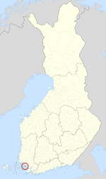
Espoo is a city and municipality in the region of Uusimaa in Finland. Espoo is situated on the northern shore of the Gulf of Finland and borders Helsinki, Vantaa, Kirkkonummi, Vihti and Nurmijärvi. The city also includes the enclave of Kauniainen. The city of Espoo covers an area of 528.03 square kilometres (203.9 sq mi) with a population of 306,792, placing it as Finland's second most populous city. Espoo is a significant part of the Helsinki Metropolitan Area, where more than 1.5 million people reside.
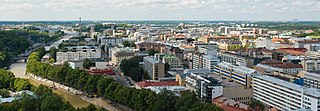
Turku is a city and former capital on the southwestern coast of Finland at the mouth of the River Aura, in the region of Southwest Finland (Varsinais-Suomi) and the former Turku and Pori Province. The region was originally called Suomi (Finland), which later became the name of the whole country. The population of Turku is 198,211 making it the sixth largest city in Finland. The Turku region has a population of 341,779, making it the third largest urban area in Finland after the Helsinki and Tampere regions. The city is officially bilingual, with 5.5 per cent of the population having Swedish as their mother tongue.

Nousiainen is a municipality of Finland. It is located in the Southwest Finland region, 20 kilometres (12 mi) from Turku along Highway 8 (E8). The Finnish-speaking municipality has a population of 4,640 (28 February 2023) and covers an area of 199.55 square kilometres (77.05 sq mi) of which 0.62 km2 (0.24 sq mi) is water. The population density is 23.34 inhabitants per square kilometre (60.5/sq mi).
The Islands of Turku consist of islands belonging to the Finnish city of Turku. There are dozens of islands and skerries, of which four have significant amounts of permanent inhabitants:

Loimaa is a town and municipality of Finland.

Masku is a municipality of Finland. It is located in the province of Western Finland and is part of the Southwest Finland region. The municipality, which is located about 17 kilometres (11 mi) just north of Turku, has a population of 9,624 (28 February 2023) and covers an area of 204.01 square kilometres (78.77 sq mi) of which 29.21 km2 (11.28 sq mi) is water. The population density is 55.03 inhabitants per square kilometre (142.5/sq mi).

Myrskylä is a municipality of Finland. It is located in the Uusimaa region and it is the smallest municipality in the region in relation to its population; the municipality has a population of 1,756 and covers an area of 206.35 square kilometres (79.67 sq mi) of which 5.98 km2 (2.31 sq mi) is water. The population density is 8.76 inhabitants per square kilometre (22.7/sq mi). Neighbouring municipalities are Askola, Porvoo, Pukkila, Orimattila, Lapinjärvi and Loviisa.

Saarijärvi is a town and municipality of Finland. It is located in the Central Finland region. The municipality has a population of 8,987 (28 February 2023) and covers an area of 1,422.72 square kilometres (549.32 sq mi) of which 170.8 km2 (65.9 sq mi) is water. The population density is 7.18 inhabitants per square kilometre (18.6/sq mi).

Virolahti is the southeasternmost municipality of Finland on the border of Russia. It is located in the Kymenlaakso region. The municipality has a population of 2,979 and covers an area of 558.92 square kilometres (215.80 sq mi), of which 186.97 km2 (72.19 sq mi) is water. The population density is 8.01 inhabitants per square kilometre (20.7/sq mi).

Maaria is a former municipality of Finland in what is now the northern part of the city of Turku. The area has been inhabited since the Iron Age, and it became an important village in the 15th century with the construction of a church dedicated to the Virgin Mary. Also Koroinen, with the former residence of the Bishop of Finland is in the area. The municipality of Maaria was founded in 1868, and it included the northern parts of modern Turku south of Paattinen, some enclaves to the north of Paattinen, and the island of Hirvensalo to the south of Turku.
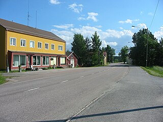
Paattinen is a village in south-west Finland and a district of the city of Turku. It is located to the north of the city, and is the largest of the city's districts by area. It borders the neighbouring municipalities of Vahto, Nousiainen, Mynämäki, Pöytyä, Aura and Lieto. It is rather sparsely populated, and has a population of only 2,430 despite being much larger than any other of the city's districts. Paattinen has an annual population growth rate of 0.99%.

Hirvensalo is an island in the Archipelago Sea, belonging to the city of Turku, Finland. It is divided into 14 districts, the largest ones being Moikoinen, Kukola and Haarla. Most of the island's economic activity is concentrated in the suburb of Moikoinen, which has a school, shops, a Lutheran church, and a post office. The island's total population is approximately 9,000.
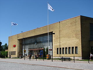
Turku Central Station is a railway station in the VII District of Turku, Finland. It has VR services to Helsinki and towards Joensuu. The station serves approximately a million passengers annually.

Satava is a large island in the Archipelago Sea, off the coast of the city of Turku, Finland. The island is located between Hirvensalo and Kakskerta, and as with many Finnish islands, it has a large amount of summer residences. Satava is also a district of Turku, encompassing the island itself and some surrounding smaller islands, such as Kulho and Järvistensaari.

Hirvensalo-Kakskerta is a ward of Turku, Finland, also known as Ward 2. The ward consists of the islands of Hirvensalo, Satava and Kakskerta, as well as some smaller islands, in the Archipelago Sea off the city's coastline.

Maaria-Paattinen is a ward of Turku, Finland, also known as Ward 9. The ward includes almost half of the city's land area, and is its most sparsely populated district. It is located to the north of the city, and named after Maaria and Paattinen, the two former municipalities from which it was formed after both of them were annexed into Turku.

The Turku Region, The City Region of Turku and Greater Turku all refer to regions of different size surrounding Turku, the capital city of the region of Southwest Finland. The Turku Region is one of the Sub-regions of Finland. The Turku Region has a population of 362,270, making it the third largest region in Finland after Helsinki and Tampere.

Turku City Library is a municipal public library in Turku. The Main Library is located in the VI District at the city centre. The Turku City Library also operates several branch libraries and two mobile libraries. It is part of the Vaski library network, which is a consolidation of 18 public libraries in the Southwest Finland region.

The Old Great Square is a medieval market square located in the city centre of Turku, Finland. It is located in the II District in very close proximity to Turku Cathedral. The area was the administrative and commercial centre of Turku since the founding of the city in the 13th century up until the Great Fire of Turku.
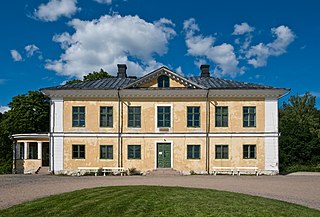
Brinkhall Manor is a historic manor house on Kakskerta island in the municipality of Turku, Finland.
