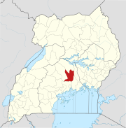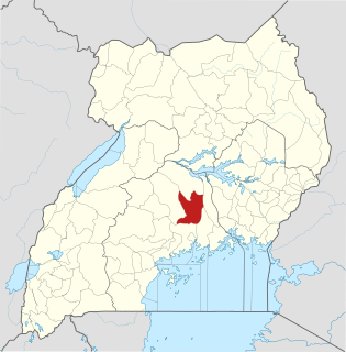
Luweero District is a district in the Central Region of Uganda. Luweero is the site of the district headquarters.

Luweero is a town in the Central Region of Uganda. It is the main municipal, administrative, and commercial center of Luweero District.
Bombo is a town in Luweero District in the Central Region of Uganda.

Bugema University (BMU) is a private, co-educational Ugandan university affiliated with the Seventh-day Adventist Church. It is a part of the Seventh-day Adventist education system, the world's second largest Christian school system.
Nsangi is a town in the Central Region of Uganda. It is one of the urban centers in Wakiso District.
Kiwoko is a small town in the Central Region of Uganda. It is one of the municipalities in Nakaseke District.
Wakyaato is a town in Nakaseke District, Central Uganda. The correct spelling of the town is with two "a"s after the "y". However, some sources have the wrong spelling with one "a".
Nakaseke General Hospital, also Nakaseke Hospital, is a hospital in the Central Region of Uganda.
Bamunanika, whose correct phonetic spelling is Baamunaanika is a town in, Luweero District in Central Uganda.
Ziroobwe is a town in Luweero District in the Central Region of Uganda. The correct phonetic spelling in the native Luganda language is "Ziroobwe".
Gayaza–Ziroobwe Road is a road in central Uganda, connecting the towns of Gayaza in Wakiso District and Ziroobwe in Luweero District.
Ngoma is a small town in Nakaseke District, Central Uganda. It is one of the municipalities within Nakaseke District. Other municipalities in the district include: (a) Butalangu (b) Kapeeka (c) Nakaseke (d) Semuto and (e) Wakyaato.
Gayaza is a town in Wakiso District in the Buganda Region of Uganda.
Namulonge is a location in the Central Region of Uganda.
Ndejje is a hill in Central Uganda. The hill rises 1,240 metres (4,070 ft) above sea level. Ndejje also refers to the trading center that has developed along the southern slopes of Ndejje Hill.
Kalule is a town in Luweero District in Central Uganda.
The University of Military Science and Technology (UMST), also Lugazi National Defence University (LNDU), whose official name is Uganda Military Engineering College, is a tertiary institution of higher learning, that instructs qualified military officers and technicians in various fields of engineering and science. The university is administered by the Uganda People's Defense Force (UPDF), under the auspices of the Uganda Ministry of Defence.
Ziroobwe–Wobulenzi Road is a road in Central Uganda, connecting the towns of Ziroobwe to Bamunanika and Wobulenzi, all in Luweero District.
The Kampala–Bombo Expressway is a proposed four-lane, dual carriage highway in the Central Region of Uganda, connecting, Kampala, the capital city, and Bombo, in Luweero District.
The Kampala–Gayaza Road is a road in the Central Region of Uganda, connecting the capital city of Kampala to the town of Gayaza in the Wakiso District. The road is part of the 44 kilometres (27 mi) Kampala–Gayaza–Ziroobwe Road Project.