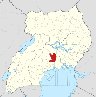
Luweero District is a district in the Central Region of Uganda. Luweero is the site of the district headquarters.

Luweero is a town in the Central Region of Uganda. It is the main municipal, administrative, and commercial center of Luweero District.

Kampala University (KU) is a fully fledged, private, chartered, recognized and accredited university in Uganda.

Bugema University (BMU) is a private, co-educational Ugandan university affiliated with the Seventh-day Adventist Church. It is a part of the Seventh-day Adventist education system, the world's second largest Christian school system.

Kapeeka is a town in Nakaseke District of the Central Region of Uganda.

Kiwoko is a small town in the Central Region of Uganda. It is one of the municipalities in Nakaseke District.
Gayaza–Ziroobwe Road is a road in central Uganda, connecting the towns of Gayaza in Wakiso District and Ziroobwe in Luweero District.

Ngoma is a small town in Nakaseke District, Central Uganda. It is one of the municipalities within Nakaseke District. Other municipalities in the district include: (a) Butalangu (b) Kapeeka (c) Nakaseke (d) Semuto and (e) Wakyaato.

Gayaza is a town in Wakiso District in the Buganda Region of Uganda.
The Kampala Northern Bypass Highway, often referred to as the Northern Bypass, is a road in Uganda. It forms a semicircle across the northern suburbs of the Kampala, Uganda's capital and largest city. The road was constructed to relieve traffic congestion within the city center, allowing cross-country traffic to bypass the city's downtown area.

Kalagala is a town in Central Uganda. It is one of the metropolitan areas in Luweero District. Other towns in the district include: Bamunanika, Bombo, Luweero, Wobulenzi and Ziroobwe.

Kalule is a town in Luweero District in Central Uganda.

Ngogwe is a municipality in Buikwe District in the Central Region of Uganda.

Olwiyo is a town in Nwoya District in the Northern Region of Uganda.

Kawanda is a town in Wakiso District, Central Uganda.
Ziroobwe–Wobulenzi Road is a road in Central Uganda, connecting the towns of Ziroobwe to Bamunanika and Wobulenzi, all in Luweero District.
The Kampala–Gayaza Road is a road in the Central Region of Uganda, connecting the capital city of Kampala to the town of Gayaza in the Wakiso District. The road is part of the 44 kilometres (27 mi) Kampala–Gayaza–Ziroobwe Road Project.
Ugachick Limited, whose complete name is Ugachick Poultry Breeders Uganda Limited, but is commonly referred to as Ugachick, is a poultry breeding and marketing company in Uganda.

Kijabijo is a neighborhood in Kira Town, in Wakiso District in the Buganda Region of Uganda.
The Kampala–Gulu Highway, also Kampala–Gulu Road, is a road connecting the capital city of Kampala, in the Buganda Region, with the city of Gulu, the largest urban centre in the Northern Region of Uganda.


