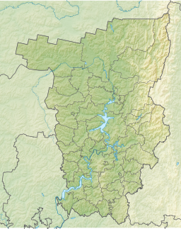
Rybinsk Reservoir, informally called the Rybinsk Sea, is a water reservoir on the Volga River and its tributaries the Sheksna and Mologa, formed by Rybinsk Hydroelectric Station dam, located in the Tver, Vologda, and Yaroslavl Oblasts. At the time of its construction, it was the largest man-made body of water on Earth. It is the northernmost point of the Volga. The Volga–Baltic Waterway starts from there. The principal ports are Cherepovets in Vologda Oblast and Vesyegonsk in Tver Oblast.
The Kama, also known as the Chulman, is a 1,805-kilometre (1,122 mi) long river in Russia. It has a drainage basin of 507,000 square kilometres (196,000 sq mi). It is the longest left tributary of the Volga and the largest one in discharge. At their confluence, in fact, the Kama is even larger in terms of discharge than the Volga.

The Chusovaya is a river flowing in Perm Krai, Sverdlovsk Oblast and Chelyabinsk Oblast of Russia. A tributary of the Kama, which in turn is a tributary of the Volga, discharges into the Chusovskoy Cove of the Kamsky Reservoir. The river is remarkable in that it originates on the eastern slopes of the Ural Mountains in Asia, crosses the mountains, and mostly runs on their western slopes in Europe. The Chusovaya River is widely used as a source of water. In particular, its water is taken from the Volchikhinsky Reservoir, 37 square kilometres (14 sq mi), to the Verkhneisetsky Reservoir to supply the major city of Yekaterinburg. Fifteen smaller reservoirs are spread over about 150 tributaries of the river.

Kuybyshev Reservoir or Kuybyshevskoye Reservoir, sometimes called Samara Reservoir and informally called Kuybyshev Sea, is a reservoir of the middle Volga and lower Kama in Chuvashia, Mari El Republic, Republic of Tatarstan, Samara Oblast and Ulyanovsk Oblast, Russia. The Kuybyshev Reservoir has a surface area of 6,450 km² and a volume of 58 billion cubic meters. It is the largest reservoir in Europe and third in the world by surface area. The major cities of Kazan, Ulyanovsk, and Tolyatti are adjacent to the reservoir.

Novosibirsk Reservoir or Novosibirskoye Reservoir, informally called the Ob Sea, is the largest artificial lake in Novosibirsk Oblast and Altai Krai, Russian Federation. It was created by a 33 m high concrete dam on the Ob River built in Novosibirsk. The dam, built in 1956, provides a water reservoir for generating hydroelectric power via Novosibirsk Hydroelectric Station. The reservoir is 200 km long and up to 17 km wide. Its area is 1,070 km2 and its volume is 8.8 km3. Its average depth is 8.3 m. The design hydroelectric power output is 460 MW, the average energy production is 1,687 GWh per year. The normal water level is 113.5 meters, the maximum water level is 115.7 meters, the minimum water level is 108.5 meters
Uglich Reservoir or Uglichskoye Reservoir is an artificial lake in the upper part of the Volga River formed by the Uglich Hydroelectric Station dam.

Chaykovsky is a town in Perm Krai, Russia, located on the Kama River 325 kilometers (202 mi) southwest of Perm, the administrative center of the krai. Population: The population as of 2023 is 75,324 people.
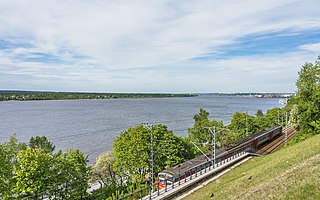
Gorky Reservoir, known colloquially as Gorky Sea, is an artificial lake in the central part of the Volga River in Russia, formed by a hydroelectric dam of Gorky Hydroelectric Station built in 1955 between the towns of Gorodets and Zavolzhye and filled in 1955 – 1957. It spans for 430 km from the dam of Rybinsk to the dam of Gorodets through Yaroslavl, Kostroma, Ivanovo and Nizhny Novgorod oblasts of Russia. While it is relatively narrow and follows the natural riverbed of Volga in the upper part, it becomes up to 16 km wide downstream the town of Yuryevets.

Toktogul Dam is a hydroelectric and irrigation dam on the Naryn River in the Jalal-Abad Province of Kyrgyzstan. It is a concrete gravity dam with height of 215 metres (705 ft) and length of 292.5 metres (960 ft). It is a part of the Naryn-Syr Darya cascade. It is named after Toktogul Satilganov.
Rybinsk Hydroelectric Station or Rybinsk GES is a hydroelectric station on the Volga and the Sheksna rivers in Yaroslavl Oblast near the Rybinsk town. It is the third of the Volga-Kama Cascade of dams.

Lower Kama Reservoir or Nizhnekamsk Reservoir is the lowest reservoir from the Kama River hydroelectric cascade. It is situated in Tatarstan, Udmurtia, Bashkortostan and Perm Krai, Russian Federation. The reservoir was filled in 1978-81 up to 62 m above sea level after the construction of dam of the Lower Kama Hydroelectric Station. The water level in reservoir depends on the upper reservoirs regime. The Lower Kama Reservoir has a surface area of 1,084 km² and a volume of 2.8 billion cubic meters. Its length along Kama is 185 km and 157 km along Belaya. The reservoir also used for water supply, irrigation and fishing.

The Kosva is a river in Perm Krai and Sverdlovsk Oblast, Russia, a left tributary of the Kama. It is 283 kilometres (176 mi) long, with a drainage basin of 6,300 square kilometres (2,400 sq mi).

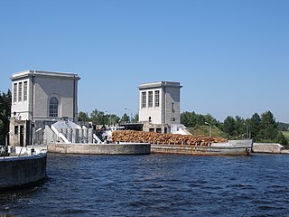
Votkinsk Reservoir is a reservoir formed by the dam of the Votkinsk Hydroelectric Station on the Kama River in Perm Krai, Russia. Besides electricity generation, the reservoir also facilitates navigation and water supply. The town of Chaikovsky is located on the reservoir.

Argazi Reservoir is a reservoir, created on the Miass River in Chelyabinsk Oblast (Russia) in 1946. The Argazi Lake has become a part of the Argazi Reservoir ever since. The reservoir has a surface area of 102 km² and a water volume of 0,65 cubic km. Its length is 11 km, average depth - 6,5 m. The Argazi Reservoir was created for the benefit of energetics and water supply. It also performs perennial flow regulation.
The Volgograd Reservoir is a reservoir on the Volga river in the Russian oblasts of Volgograd and Saratov. The reservoir's water level is maintained by the dam of the Volga Hydroelectric Station, built from 1958 to 1961.
Kapchagay or Qapshaghay Reservoir, also known as the Qapshaghay Bogeni Reservoir and sometimes referred to as Lake Kapchagay, is a major reservoir in Almaty Region in southeastern Kazakhstan, approximately 80 km (50 mi) north of Almaty. The 140 km (87 mi) long lake is formed by the Kapchagay Dam on the Ili River which flows from the mountains in the east towards Lake Balkhash to the northwest. The dam and reservoir are named for the "narrow gorge" that preceded their construction; Iliysk—which had to be moved to accommodate the reservoir—was renamed Kapchagay after the dam in 1970; it was subsequently renamed Qonayev in 2022. During the summer months the lake attracts a number of tourists from Almaty, who frequent its beachy shores on the weekends.

The Zeya Dam is a concrete gravity dam on the Zeya River by the town of Zeya, Amur Oblast, Russia, north of the Chinese border. On average the Zeya Hydroelectric Power Station generates 4.91 TWh of electricity per year. It is equipped with 6 hydro-turbines, 4 with capacity of 225 MW and 2 with capacity of 215 MW.
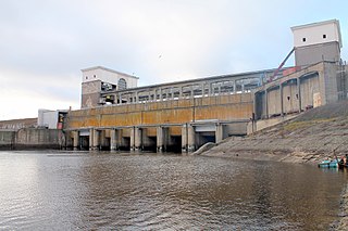
The Votkinsk Hydroelectric Station is a dam and hydroelectric power station on the Kama River along the border of Perm Krai and Udmurtia, Russia. It is 30 km (19 mi) south of Votkinsk and its main purpose is power generation and navigation. The power station has a 1,100 MW installed capacity and the dam also supports a ship lift. Construction on the dam began in 1955, the first generator was operational in 1961 and the last in 1963. The entire project was complete in 1965.

Kayrakkum Reservoir, also spelled variously as Qayroqqum,Qayraqqum,Kayrakum or Kairakum, is a large artificial lake in Ghafurov District of Sughd Province, in northwestern Tajikistan. In 2016, the reservoir was renamed Tajik Sea by the country's parliament. The reservoir lies in the western part of the Fergana Valley on the Syr Darya river. The provincial capital of Khujand lies about 15 km (9.3 mi) west of the dam. It is also a Ramsar site.

KolymaReservoir is an artificial lake which was created by the construction of the Kolyma Hydroelectric Station on the Kolyma. It was designed by Lenhydroproject. Filling began in 1980 and it was commissioned in 1995.