
The ca. 1000 km long Tana River is the longest river in Kenya, and gives its name to the Tana River County. Its catchment covers ca. 100,000 km² and can be divided into the headwaters and the lower Tana consisting of the section downstream of Kora where the river flows for ca. 700 km through semi-arid plains. Its tributaries include the Thika, as well as several smaller rivers that flow only during the rainy season. The river rises in the Aberdare Mountains to the west of Nyeri. Initially it runs east before turning south around the massif of Mount Kenya. A series of hydroelectric dams has been constructed along the river. These include the Masinga Dam, the Kamburu Dam, the Gitaru Dam, the Kindaruma Dam and the Kiambere Dam .en The Masinga Reservoir and the Kiambere Reservoir, created by the Masinga and Kiambere dams respectively, serve a dual purpose: hydro-electric power (HEP) generation and agricultural irrigation. The other three are used exclusively for HEP generation. A 2003 study reported that two-thirds of Kenya's electrical needs were supplied by the series of dams along the Tana River. Many people believe this river has groundwater underneath it, but it doesn't. The electricity is then supplied to the national grid system and distributed countrywide through a series of substations, transformers and cables.

The Nurek Dam is an earth-fill embankment dam on the Vakhsh River in Tajikistan. Its primary purpose is hydroelectric power generation and its power station has an installed capacity of 3,015 MW. Construction of the dam began in 1961 and the power station's first generator was commissioned in 1972. The last generator was commissioned in 1979 and the entire project was completed in 1980 when Tajikistan was still a republic within the Soviet Union, becoming the tallest dam in the world at the time. At 300 m (984 ft), it is currently the second tallest man-made dam in the world, after being surpassed by Jinping-I Dam in 2013. The Rogun Dam, also along the Vakhsh in Tajikistan, may exceed it in size when completed.

Tarbela Dam is an earth-filled dam along the Indus River in Pakistan's Khyber Pakhtunkhwa province. Located in the Haripur mainly and in some area of Swabi of the province, the dam is about 30 km (20 mi) from the city of Swabi, 105 km (65 mi) northwest of Islamabad, and 125 km (80 mi) east of Peshawar. It is the largest earth-filled dam in the world, and also the largest dam by structural volume.

The Robert Moses Niagara Hydroelectric Power Station is a hydroelectric power station in Lewiston, New York, near Niagara Falls. Owned and operated by the New York Power Authority (NYPA), the plant diverts water from the Niagara River above Niagara Falls and returns the water into the lower portion of the river near Lake Ontario. It uses 13 generators at an installed capacity of 2,675 MW (3,587,000 hp).

Kenya Electricity Generating Company or simply KenGen is a parastatal company, and is the largest electric power producer in Kenya producing about 75% of the electricity consumed in the country.

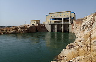
The Gitaru Hydroelectric Power Station, also known as the Gitaru Dam, is a rock and earth-filled embankment dam on the Tana River in Kenya. It straddles the border between Embu and Machakos Counties in the former Eastern Province. The primary purpose of the dam is hydroelectric power generation, and it supports a 225 megawatt power station.
The Kiambere Hydroelectric Power Station is an earth-filled embankment dam on the Tana River near Kiambere, Kenya. It straddles the border of Embu and Kitui Counties in Eastern Province. The primary purpose of the dam is hydroelectric power generation and it supports a 165 MW power station. Construction on the dam began in 1983 and it was completed in 1987. The power station was commissioned in 1988. Beginning in 2008 both turbine-generators were upgraded from 72 MW to 82.5 MW. They were commissioned in 2009. US$95 million in funding for the original project was provided by the World Bank. The power station is operated by Kenya Electricity Generating Company and is part of the Seven Forks Scheme.
The Turkwel Hydroelectric Power Station, also Turkwel Dam, is an arch dam on the Turkwel River about 76 km (47 mi) north of Kapenguria in West Pokot County, Kenya. The dam serves several purposes to include hydroelectric power production, irrigation tourism and fisheries. It was constructed between 1986 and 1991. It supports the third largest hydroelectric power plant in the country, having an installed electric capacity of 106 megawatts (142,000 hp).

The Gilgel Gibe III Dam is a 250 m high roller-compacted concrete dam with an associated hydroelectric power plant on the Omo River in Ethiopia. It is located about 62 km (39 mi) west of Sodo in the Southern Nations, Nationalities, and Peoples' Region. Once fully commissioned, it will be the third largest hydroelectric plant in Africa with a power output of about 1870 Megawatt (MW), thus more than doubling total installed capacity in Ethiopia from its 2007 level of 814 MW. The Gibe III dam is part of the Gibe cascade, a series of dams including the existing Gibe I dam and Gibe II power station as well as the planned Gibe IV and Gibe V dams. The existing dams are owned and operated by the state-owned Ethiopian Electric Power, which is also the client for the Gibe III Dam.

The Zimapán Dam, also known as Fernando Hiriart Balderrama Dam, is an arch dam on the Moctezuma River about 15 km (9 mi) southwest of Zimapán in Hidalgo state, Mexico. The primary purpose of the dam is hydroelectric power production and it services a 292 MW power station with water.

The Aguamilpa Dam is an embankment dam on the Río Grande de Santiago in the Mexican state of Nayarit, 38 km (24 mi) northeast of Tepic. The primary purpose of the dam is hydroelectric power generation and it supplies a 960 MW power station with water. Construction on the dam began in 1989 and it was completed in 1993 while the power station became operational in 1994.
The Upper Cisokan Pumped Storage Plant is a proposed pumped-storage hydropower facility in Indonesia, due for completion by 2025.

The Çetin Dam hydropower dam, currently being constructed on the Botan River in Siirt Province, Turkey, with an installed capacity of 420 MW. It is expected to complete by 2020.
The Kindaruma Hydroelectric Power Station, also Kindaruma Dam is an embankment dam with two gravity dam sections on the Tana River in Kenya. It straddles the border of Embu and Machakos counties in Kenya. The primary purpose of the dam is hydroelectric power generation and it supports a 72 megawatts (97,000 hp) power station. It is Kenya's first post-independence hydroelectric power plant. It was commissioned in 1968 as part of the Seven Forks Scheme. The power station is operated by Kenya Electricity Generating Company.

The Kukule Ganga Dam is a 110 m (360 ft) gravity dam built across the Kukule River in Kalawana, Sri Lanka. The run-of-river-type dam feeds an underground hydroelectric power station located approximately 5 kilometres (3.1 mi) away, via tunnel.
The Félou Hydroelectric Plant is a hydroelectric installation at the Félou Falls on the Sénégal River in Mali. It has three water turbines capable of generating 62.3 MW. The current power station replaced an older one built in the 1920s. Construction of the new power station began in October 2009 and was financed by the World Bank. It is the third Senegal River Basin Development Authority project on the river and was completed in 2014. The existing weir was refurbished with the previous 2 metres (6.6 ft) height maintained. In 1927, the previous hydroelectric power station was commissioned. It was refurbished in 1992 and had an installed capacity of 600 kW.
Masinga Hydroelectric Power Station, also Masinga Dam, is an embankment dam on the Tana River, the longest river in Kenya. It straddles the border of Embu and Machakos Counties in Eastern Province and is located about 106 km. (66 mi.), by road, northeast of Nairobi, Kenya's capital and largest city.

The Kulekhani Dam is a rock-fill dam on the Kulekhani River near Kulekhani in Makwanpur District of Narayani Zone, Nepal. The primary purpose of the dam is hydroelectric power generation and it supports the 60 MW Kulekhani I and 32 MW Kulekhani II Hydropower Stations. Construction began in 1977 and Kulekhani I was commissioned in 1982. Kulekhani II was commissioned in 1986 and a third power station, the 14 MW Kulekhani III was expected to be commissioned in May 2015 but is delayed due to issues with the builder. The project has not been completed until the year 2017 and is expected to generate electricity by the end of 2018. The US$117.84 million project received funding from the World Bank, Kuwait Fund, UNDP, Overseas Economic Cooperation Fund and OPEC Fund. It is owned by Nepal Electricity Authority.
The Tana Hydroelectric Power Station is a 20 MW (27,000 hp) hydroelectric power station on the Tana River in southern Kenya.
