
Camenca is a town in Transnistria, a breakaway republic internationally recognized as part of Moldova. It is composed of the town itself and the village of Solnecinoe. Camenca is the seat of Camenca District. The town is located on the Dniester, in the north of Transnistria.

Kamenka is a town and the administrative center of Kamensky District in Penza Oblast, Russia, located on the Atmis River 80 kilometers (50 mi) west of Penza, the administrative center of the oblast. Population: 39,577 (2010 Russian census); 40,712 (2002 Census); 27,235 (1989 Soviet census); 30,000 (1970).

Rașcov is one of the oldest communes of Transnistria. It is located in the northern part, between Rîbnița and Camenca. It is composed of two villages, Iantarnoe and Rașcov.
5385 Kamenka, provisional designation 1975 TS3, is a background asteroid from the outer regions of the asteroid belt, approximately 16 kilometers (10 miles) in diameter. It was discovered on 3 October 1975, by Soviet astronomer Lyudmila Chernykh at the Crimean Astrophysical Observatory in Nauchnij, on the Crimean peninsula. The presumed C-type asteroid has a rotation period of 6.68 hours. It was named for the Ukrainian town of Kamianka.
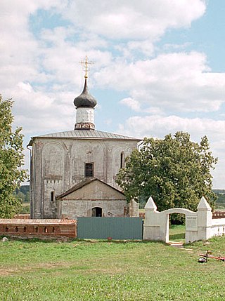
Kideksha is a village (selo) in Seletskoye Rural Settlement, Suzdalsky District of Vladimir Oblast, Russia, located at the confluence of the Kamenka and Nerl Rivers, 4 kilometers (2.5 mi) east of Suzdal. The name derives from keaδkē (stone) and śäčä (flood), hence "stony river"; the Russian "Kamenka" has a similar meaning.
Gacyclidine is a psychoactive drug which acts as a dissociative via functioning as a non-competitive NMDA receptor antagonist. It is closely related to phencyclidine (PCP), and specifically, is a derivative of tenocyclidine (TCP).

Benocyclidine, also known as benzothiophenylcyclohexylpiperidine (BTCP), is a psychoactive recreational drug of the arylcyclohexylamine class which is related to phencyclidine (PCP). It was first described in a patent application naming Marc Caron and colleagues at Duke University in 1997.
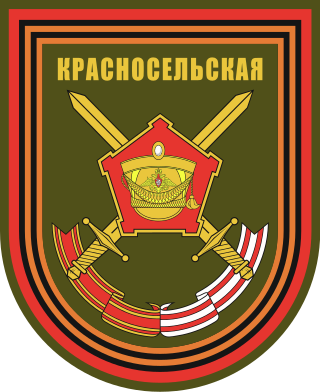
The 138th Guards Separate Motor Rifle Brigade is a formation of the Russian Ground Forces. It is stationed in the Western Military District, in the village of Kamenka, Vyborgsky District, Leningrad Oblast. It is Military unit No. 02511. It includes various components: air defense, artillery battalion, infantry and tank battalions.
Kamenka is the name of several inhabited localities in Russia.
Kamenka is a village in Almaty Region, in south-eastern Kazakhstan.
Events from the year 1609 in Sweden
Kamenka is a rural locality in Chebenlinsky Selsoviet, Alsheyevsky District, Bashkortostan, Russia. The population was 54 as of 2010. There is 1 street.
Kamenka is a rural locality in Meselinsky Selsoviet, Aurgazinsky District, Bashkortostan, Russia. The population was 66 as of 2010. There is 1 street.
Kamenka is a rural locality and the administrative centre of Kamensky Selsoviet, Bizhbulyaksky District, Bashkortostan, Russia. The population was 512 as of 2010. There are 8 streets.
Kamenka is a rural locality in Danilovskoye Rural Settlement, Melenkovsky District, Vladimir Oblast, Russia. The population was 13 as of 2010.
Kamenka is a rural locality in Simskoye Rural Settlement, Yuryev-Polsky District, Vladimir Oblast, Russia. The population was 85 as of 2010.
Kamenka is a rural locality in Dyakonovskoye Rural Settlement, Uryupinsky District, Volgograd Oblast, Russia. The population was 51 as of 2010.
Kamenka is a rural locality in Chushevitskoye Rural Settlement, Verkhovazhsky District, Vologda Oblast, Russia. The population was 560 as of 2002. There are 8 streets.
Kirpichny Zavod is a rural locality in Vokhtozhskoye Rural Settlement, Gryazovetsky District, Vologda Oblast, Russia. The population was 104 as of 2002.
