
The Rhodopes are a mountain range in Southeastern Europe, and the largest by area in Bulgaria, with over 83% of its area in the southern part of the country and the remainder in Greece. Golyam Perelik is its highest peak at 2,191 meters (7,188 ft). The mountain range gives its name to the terrestrial ecoregion Rodope montane mixed forests that belongs in the temperate broadleaf and mixed forests biome and the Palearctic realm. The region is particularly notable for its karst areas with their deep river gorges, large caves and specific sculptured forms, such as the Trigrad Gorge.

The Srebarna Nature Reserve is a nature reserve in northeastern Bulgaria, near the village of the same name, 18 kilometers (11 mi) west of Silistra and two kilometers (1.2 mi) south of the Danube. It comprises Lake Srebarna and its surroundings, and is an important wetland located on the Via Pontica, a bird migration route between Europe and Africa. As a result, it provides nesting and migratory habitat for many endangered bird species.
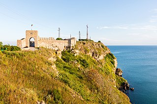
Kaliakra is a cape in the Southern Dobruja region of the northern Bulgarian Black Sea Coast, which ends with a long and narrow headland 12 kilometres (7 mi) east of Kavarna, 60 kilometres (37 mi) northeast of Varna and 65 kilometres (40 mi) southwest of Mangalia. The coast is steep with vertical cliffs reaching 70 metres (230 ft) down to the sea. Kaliakra is a nature reserve, where dolphins and cormorants can be observed. It sits on the Via Pontica, a major bird migration route from Africa into Eastern and Northern Europe. Many rare and migrant birds can be seen here in spring and autumn and, like much of this coastline, is home to several rare breeding birds. The rest of the reserve also has unusual breeding birds; saker falcon, lesser grey shrike and a host of others.

The Battle of Turtucaia, also known as Tutrakan Epopee in Bulgaria, was the opening battle of the first Central Powers offensive during the Romanian Campaign of World War I. The battle lasted for five days and ended with the capture of the fortress of Turtucaia and the surrender of its Romanian defenders.
The Central Balkan National Park is a national park in the heart of Bulgaria, nestled in the central and higher portions of the Balkan Mountains. Its altitude varies from 550 metres (1,800 ft) near the town of Karlovo to 2,376 metres (7,795 ft) at Botev Peak, the highest summit in the range. It was established on 31 October 1991.
The Ropotamo is a river in south-eastern Bulgaria. It takes its source from the Bosna Ridge in the Strandzha Mountains, running for 48.5 km to empty into the Black Sea near Cape Saint Demetrius between Dyuni and Primorsko.

State Reserves of Azerbaijan refers to the state reserves in Azerbaijan, which preserve the fauna, flora and their ecosystems.
Avren is a village in northeastern Bulgaria, part of Varna Province. It is the administrative centre of the homonymous Avren Municipality in the eastern part of Varna Province.

The Kamchia Biosphere Reserve, is a former UNESCO-listed biosphere reserve on the northern coastline of Bulgaria, comprising the floodplain at the mouth of the Kamchia River. Consisting largely of alluvial longose groves,, but also featuring some of the Black Sea coastline, the area of the protected habitats in the reserve, together with Kamchia Sands Protected Area, totals 1.200 ha. Established in 1977, it protects the primeval forest from the intensive logging and drainage that had decimated it by mid-20th century. It is situated 25 km south of the town of Varna and is enclosed by the villages of Staro Oriahovo, Shkorpilovtsi and Bliznatsi.
Dimchevo is a village in Burgas Municipality, in Burgas Province, in southeastern Bulgaria.
Ahryansko is a village in Ardino Municipality, Kardzhali Province, southern-central Bulgaria. It is located 191.083 kilometres (118.733 mi) from Sofia. It covers an area of 6.839 square kilometres and in 2007 had a population of 51.

Khosrov Forest State Reserve, is a nature reserve in Ararat Province of Armenia. The reserve is one of the oldest protected areas in the world having a history of about 1,700 years. It was founded in the 4th century (334–338) by the order of king Khosrov Kotak, who gave it his name. It was founded to improve the natural climatic conditions of adjacent territories of Artashat – the capital city of Armenia of the given period and the newly established city of Dvin to ensure conservation and enrichment of flora and fauna; serve as a ground for royal hunting, military exercises and entertainment.
Krivnya is a village in northeastern Bulgaria, part of Vetovo Municipality, Ruse Province. Krivnya is picturesquely situated in the valley of the Beli Lom River in the western part of the Ludogorie located in the hilly Danubian Plain (Bulgaria). The village is surrounded by rock formations, among which the river meanders and divides the village into two parts. In the past the river flowed slowly making a big curve and forming a sort of peninsula. In the last century (1959) an artificial correction of the riverbed is made by using of explosions and the rock formation is "cut." Today this place is known as " Prosyakata." The altitude of the area ranges between 100 and 200 meters. Relief, except the rocky formations around the river is favorable for agriculture. The climate is continental with hot summers and cold winters. The village is located 3 km from the Ruse-Varna railway line and between the towns of Vetovo and Senovo, Ruse Province.
Bagryanka is a village in Momchilgrad Municipality, Kardzhali Province, southern Bulgaria.
Manchevo is a village in Momchilgrad Municipality, Kardzhali Province, southern Bulgaria. The last reported population of this village was just 1 person in 2013.

Strandzha Nature Park is the largest protected area in Bulgaria spanning a territory of 1,161 square kilometres (448 sq mi) in the Strandzha Mountain in the extreme south-eastern corner of the country on the border with Turkey. It was established on 25 January 1995 to protect ecosystems and biodiversity of European importance, as well as the traditional cultural, historical and folklore heritage of the region. The altitude varies from 710 metres (780 yd) on Gradishte Peak to 0 metres (0 yd) at the Black Sea coast with average length of 50 kilometres (31 mi) from west to east and 20 kilometres (12 mi) from north to south.

Yulen is a nature reserve in Pirin National Park, located in the homonymous mountain range in south-western Bulgaria. It is situated in Bansko Municipality, Blagoevgrad Province. Yulen was declared on 26 August 1994 to monitor the growth of alpine plant species without human influence, as well as to protect rare plant and animal species. It spans a territory of 3156 ha or 31.56 km2.

Uchilishtna Gora is a maintained nature reserve in the Balkan Mountains of Bulgaria, located in the territory of Bozhenitsa village, in the municipality of Botevgrad, Sofia Province. The closest settlements are the villages of Bozhenitsa (2.3 km), Lipnitsa (4.3 km) and Skravena (5 km). The area of the maintained reserve is 134.7 hectares.

Rivnenskyi Nature Reserve is a strict nature reserve in the northwest of Ukraine, created to protect and study the representative landscape of the Polesia region. It was established by the President of Ukraine, Leonid Danylovych Kuchma, on April 3, 1999. In accordance with the Resolution of the Cabinet of Ministers of Ukraine on August 14, 2003, the reserve was permanently transferred to a land area of 42,288 km2.

The fortress of Kipilovo was one of the Byzantine Empire's military fortresses built to defend Constantinople. The ruins of the fortress are located on Mount Hisarlaka in the Balkan Mountains - 3.4 km south in a straight line from the center of the village Kipilovo, in central Bulgaria.
