
The Beskids or Beskid Mountains are a series of mountain ranges in the Carpathians, stretching from the Czech Republic in the west along the border of Poland with Slovakia up to Ukraine in the east.

Pančić's Peak is the highest point in the Kopaonik mountain range, which straddles southern Serbia and northern Kosovo. The peak is 2,017 m high, located in the Brus municipality in Serbia. The Serbia–Kosovo demarcation line lies some 50 m south of the summit. Pančić's Peak is part of the Suvo Rudište mountainous plateau and natural zone of the Kopaonik National Park. The Kopaonik tourist center operates cable cars to Pančić's Peak and Suvo Rudište Peak.
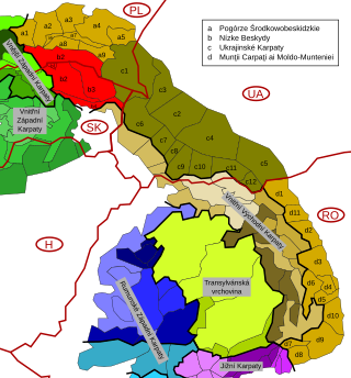
The Low Beskids or Central Beskids are a mountain range in southeastern Poland and northeastern Slovakia. They constitute a middle (central) section of the Beskids, within the Outer Eastern Carpathians.

Szczawa is a village in the administrative district of Gmina Kamienica, within Limanowa County, Lesser Poland Voivodeship, in southern Poland. It lies approximately 5 kilometres (3 mi) north-west of Kamienica, 15 km (9 mi) south-west of Limanowa, and 58 km (36 mi) south-east of the regional capital Kraków.
Czajków Północny is a village in the administrative district of Gmina Staszów, within Staszów County, Świętokrzyskie Voivodeship, in south-central Poland. It lies approximately 9 kilometres (6 mi) east of Staszów and 59 km (37 mi) south-east of the regional capital Kielce.
Sielec is a village in the administrative district of Gmina Staszów, within Staszów County, Świętokrzyskie Voivodeship, in south-central Poland. It lies approximately 4 kilometres (2 mi) south-west of Staszów and 52 km (32 mi) south-east of the regional capital Kielce.

Beszowa is a village in the administrative district of Gmina Łubnice, within Staszów County, Świętokrzyskie Voivodeship, in southern Poland. It lies approximately 3 kilometres (2 mi) north-west of Łubnice, 16 km (10 mi) south of Staszów, and 62 km (39 mi) south-east of the regional capital Kielce.
Potok is a village in the administrative district of Gmina Szydłów, within Staszów County, Świętokrzyskie Voivodeship, in south-central Poland. It lies approximately 8 kilometres (5 mi) north-west of Szydłów, 18 km (11 mi) north-west of Staszów, and 36 km (22 mi) south-east of the regional capital Kielce.
Potok Rządowy is a village in the administrative district of Gmina Szydłów, within Staszów County, Świętokrzyskie Voivodeship, in south-central Poland. It lies approximately 6 kilometres (4 mi) north of Szydłów, 17 km (11 mi) north-west of Staszów, and 38 km (24 mi) south-east of the regional capital Kielce.
The Commission for the Determination of Place Names was a commission of the Polish Department of Public Administration, founded in January 1946. Its mission was the establishment of toponyms for places, villages, towns and cities in the former eastern territories of Germany.

The Western Beskids are a set of mountain ranges spanning the Czech Republic, Slovakia, and Poland. Geologically the Western Beskids are part of the Outer Western Carpathians.

The Gorce Mountains are part of the Western Beskids mountain range spreading across southernmost Poland. They are situated in Małopolska Province, at the western tip of the long Carpathian range extending east beyond the Dunajec River for some 1,500 kilometres (930 mi). The Gorce are characterized by numerous ridges reaching in all directions for up to 40 kilometres (25 mi) east–west with a series of higher elevations cut by deep river valleys.

Beskid Sądecki is a mountain range in the eastern section of the Western Beskids, within the Outer Western Carpathians. It is located in the border region between Poland and Slovakia. On the Polish side, it stretches along an area of 670 km², between the Dunajec river in the west and the valleys of the Kamienica Nawojowska river, Mochnaczka, Muszynka, Przełęcz Tylicka in the east. The highest peak of the mountain range is Radziejowa at 1262 metres. The mountains are built from flysch rocks.
Asenovo - a village in South-Eastern Bulgaria in the Yambol Province, in the Tundzha Municipality. According to the National Institute of Statistics, in the year of 2011, the village had 93 inhabitants. The Holy Assembly Council takes place on 24 May.
Bolyarsko - a village in South-Eastern Bulgaria in the Yambol Province, in the Tundzha Municipality. According to the National Institute of Statistics, in the year of 2011, the village had 327 inhabitants. The Holy Assembly Council takes place on 24 May.

Dobrzynka - is a river in Poland with an approximate length of 25.5 km.

The Czarny Dunajec is a river in southern Poland, in the Vistula basin.

The Orava-Nowy Targ Basin is the northern, lowest part of the Podhale-Magura Area, between the Western Beskids in the north and the Spisko-Gubałowski Highlands in the south.

Syalyava or Selyava is a lake in Minsk Voblast, Krupki District, Belarus. It is located 20 km from Krupki.

