The Brunei–Muara District or simply Brunei–Muara is one of the four districts of Brunei. It has the smallest area among the four districts, with 571 square kilometres (220 sq mi), yet is the most populous, with 289,630 people as of 2016. Bandar Seri Begawan, the country's capital, is located in this district, which is also de facto the district's capital. It is also home to Brunei International Airport, the country's only international airport, as well as Muara Port, the main and only deep-water port in the country. The Brunei River flows within this district and is home to Kampong Ayer, the traditional historic settlement on stilts above the river.

Kampong Mumong, or simply known as Mumong, is a residential suburb of Kuala Belait, the principal town of Belait District, in Brunei Darussalam. It comprises the original Mumong settlement, as well as the Mumong public housing estate of the Landless Indigenous Citizens' Housing Scheme. However, it officially consists of two village sub-divisions, namely Mumong 'A' and Mumong 'B', which are under the mukim of Kuala Belait.

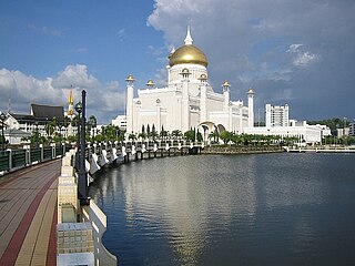
Mukim Kota Batu is a mukim in Brunei-Muara District, Brunei. The population was 12,935 in 2016. The mukim is home to some of the country's museums and historical sites, in particular in Kota Batu.

Mukim Lumapas is a mukim in Brunei-Muara District, Brunei. It has an area of 62.10 square kilometres (23.98 sq mi); the population was 7,756 in 2016.

Mukim Pengkalan Batu is a mukim in Brunei-Muara District, Brunei. The population was 14,492 in 2016.

Mukim Ukong is a mukim in Tutong District, Brunei. The population was 2,272 in 2016.

Mukim Labu is a mukim in Temburong District, Brunei. It has an area of 292 square kilometres (113 sq mi); the population was 508 in 2021.
Kampong Mentiri or simply known as Mentiri, is a village in the north-east of Brunei-Muara District, Brunei. It has an area of 322.29 hectares ; the population was 1,215 in 2016.

Kampong Serasa is a village in Brunei-Muara District, Brunei, near the port town Muara. The population was 3,200 in 2016. It is home to Serasa Ferry Terminal, the country's primary international ferry terminal.
Kampong Masin or simply known as Masin, is a village in Brunei-Muara District, Brunei, about 15.5 kilometres (9.6 mi) from the capital Bandar Seri Begawan. The population was 2,891 in 2016. It is one of the villages within Mukim Pengkalan Batu. The postcode is BH2723.

Kampong Menglait or simply known as Menglait, is a village in Brunei-Muara District, Brunei, as well as a neighbourhood and commercial area in the capital Bandar Seri Begawan. The population was 2,262 in 2016. It is one of the villages within Mukim Gadong 'B'. The postcode is BE3919.

Kampong Junjongan also Kampong Junjungan or simply Junjongan, is a village in the south-east of Brunei-Muara District, Brunei, about 16 kilometres (9.9 mi) from the capital of Brunei, Bandar Seri Begawan. According to 2016 records, the population was 2,006. It is one of the villages within Mukim Pengkalan Batu. The postcode is BH2123.
Kampong Batong is a village in the south-west of Brunei-Muara District, Brunei, about 20.5 kilometres (12.7 mi) from the capital Bandar Seri Begawan. It has an area of 978.07 hectares ; the population was 1,225 in 2016. It is one of the villages within Mukim Pengkalan Batu. The postcode is BH2923.
Kampong Pengkalan Batu is a village in Brunei-Muara District, Brunei, about 19 kilometres (12 mi) from the capital Bandar Seri Begawan. The population was 1,007 in 2016. It is one of the villages within Mukim Pengkalan Batu.

Kampong Limau Manis is a village in the south-west of Brunei-Muara District, Brunei. The population was 1,097 in 2016. It is one of the villages within Mukim Pengkalan Batu, a mukim in the district. It is home to an important archaeological site in the country, dating back to the 10th century AD. Their primary economic activities were agriculture and collecting forest products.
Kampong Wasan or simply known as Wasan, is a village in the south-west of Brunei-Muara District, Brunei. The population was 482 in 2016. It is one of the villages within Mukim Pengkalan Batu. The postcode is BH2523.

Kampong Menunggol or simply Menunggol, is a village in Brunei-Muara District, Brunei, on the island Pulau Berambang. The population was 541 in 2016. It is one of the villages within Mukim Kota Batu, a mukim in the district.
Kampong Pelambayan or simply known as Pelambayan. is a village in Brunei-Muara District, Brunei. It is also a neighbourhood in the country's capital Bandar Seri Begawan. The population was 714 in 2016. It is one of the villages within Mukim Kota Batu. The postcode is BD2317.

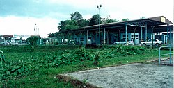
Kampong Sungai Matan or simply known as Sungai Matan, is a village in Brunei-Muara District, Brunei. It has an area of 0.36 square kilometres ; the population was 356 in 2016. It is one of the villages within Mukim Kota Batu. The postcode is BD1917. It is a cultural village in this country that is run by members of the Majlis Perundingan Kampung (MPK) with a focus on helping to advance programs and the villagers in matters of tourism and the economy.