
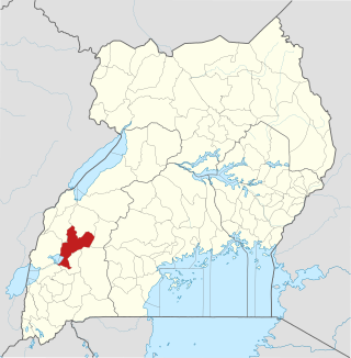
Mukono is one of the districts in the Central Region of Uganda. The town of Mukono serves as the district headquarters and is home to the district's main commercial center.
Kamwenge District is a district in Western Uganda. It is named after its 'chief town', Kamwenge, where the district headquarters are located. Kamwenge District is part of the Kingdom of Toro, one of the ancient traditional monarchies in Uganda. The kingdom is coterminous with Toro sub-region. The districts that constitute the sub-region are: (a) Bunyangabu District (b) Kabarole District (c) Kamwenge District (d) Kyegegwa District (e) Kitagwenda District and (f) Kyenjojo District.

Kibaale is a town in the Western Region of Uganda. It is the main municipal, administrative, and commercial center of Kibaale District, and the district headquarters are located there.
Nakapiripirit is a town in the Nakapiripirit District of the Northern Region of Uganda. It is the seat of the district headquarters. As an administrative unit of the district, it is one of the eight sub-counties in the district.
Kyenjojo is a town in the Western Region of Uganda. It is the main municipal, administrative, and commercial center of Kyenjojo District and the site of the district headquarters.
Ibanda is a town in the Western Region of Uganda. It is the main political, administrative, and commercial centre of Ibanda District and the site of the district headquarters. It started way back in the 1990s and was elevated from a trading centre to a town board, town council and in 2016 it was granted the municipality status. The Municipal Council has three Divisions of Kagongo, Bisheshe and Bufunda with 21 wards of Kyaruhanga, Bufunda, Nyamirima, Nsasi, Kayenje, Kashangura, Rwenshuri, Kigarama, Rugazi, Rwobuzizi, Kakatsi, Bugarama, Karangara, Kabaare, Kanyansheko, Nyakatookye, Kyeikucu, Kikoni, Kagongo, Ruyonza and Katongore ward. Ibanda Municipal Council has over 230 villages. Ibanda Municipal council commenced its operations on 1 July 2016 after being elevated from a Town Council and other sub counties that were annexed to..

Mukono Town is a municipality in Mukono District in the Central Region of Uganda. The town is administered by the Mukono Town Council. The district headquarters are located in this town.

Kumi Town, commonly called Kumi, is a town in the Eastern Region of Uganda. It is the main municipal, administrative, and commercial center in Kumi District and the site of the district headquarters.

Kiruhura is a town in the Western Region of Uganda. It is the largest town in Kiruhura District and the site of the district headquarters.
Kyotera is a town in the southern part of the Central Region of Uganda. It is a municipality in Kyotera District. However, the district headquarters are located at Kasaali.
Kagadi is a town in the Western Region of Uganda. It is the commercial and administrative headquarters of Kagadi District.
Mpanga Power Station is an 18 megawatts (24,000 hp) mini hydroelectric power project located across River Mpanga, in Kitagwenda County, Kitagwenda District in Western Uganda.

Buhweju District is a district in Western Uganda. It is one of the districts that constitute the Ankole sub-region. Its 'chief town', is Nsiika.

Ntoroko District is a district in the Western Region of Uganda. The district headquarters are in the Kibbuuku town council. It is the second least populated district in Uganda.
Nyakahita is a sparsely populated settlement in the Western Region of Uganda.

Kazo is a town in the Western Region of Uganda. It is the capital of Kazo District.
Bunyangabu District is a district in the Western Region of Uganda. The town of Kibiito is the political and administrative center of the district. However, the town of Rwimi, is the largest and main commercial center of Bunyangabu.
Kibiito is a town in the Western Region of Uganda. It is the chief administrative center of Bunyangabu District, and the district headquarters are located there.
Rubona is a town in the Western Region of Uganda.
Kitagwenda District is a district in Western Uganda. The district is named after Kitagwenda County, which is coterminous with the district.

