Kyambura Game Reserve | |
---|---|
Location | Rubirizi district |
Nearest city | Kasese Town |
Coordinates | 0°08′13″S30°05′02″E / 0.137°S 30.084°E |
Area | 156 square units[ clarification needed ] |
Max. elevation | 1100m |
Min. elevation | 700m |
Established | 1965 |
Governing body | Uganda Wildlife Authority |
World Heritage site | 1965 |
Kyambura Game Reserve or Chambura Game Reserve, which includes the Kyambura Gorge, adjoins the Queen Elizabeth National Park in Uganda. It is home to a variety of wildlife. The area is an important water source for many animals and is surrounded by savanna, but is generally noted for its high concentration of primate life located in the gorge. [1]
Kyambura Game Reserve was formed as the Kyambura Controlled Hunting Area in 1962, and upgraded to game reserve status in 1965. In the 1980s the southern area was colonised, but these people were evicted in 1990, and the land rented out to a private concessionaire called Zwilling. After the Uganda Wildlife Statute of 1996 changed the name of all game reserves to wildlife reserves, the reserve became formally known as the Kyambura Wildlife Reserve. The hunting concession was terminated in 1999 due to illegal hunting. [2] : 11, 12
It serves as a buffer zone to the Queen Elizabeth National Park (QENP). [1] [3]
Kyambura is located on north-eastern side of QENP, approximately 30 km from QENP Headquarters. Kyambura Gorge spans a distance of 11 km and links to the Kazinga Channel, which forms the northern bInfobox protected area oundary of the reserve. Village and plantations lie to the south. The reserve's mean altitude is 1100 m.a.s.l. The total area of the reserve is 156 sq. km. [3] [4]
Kyambura and QENP, together with Maramagambo Forest and Kigezi Game Reserve, all adjoin, and are referred to as the Queen Elizabeth Protected Area (QEPA), this borders Parc National des Virunga (Virunga National Park) in the Democratic Republic of the Congo, and together these areas completely encircle Lake Edward. Other nearby protected areas are Kibale National Park to the northeast and Rwenzori Mountains National Park to the northwest. [2] : 2
The landscape is gentle rolling savanna grassland, but is deeply cut by the 16 km Kyambura Gorge, which supports a thick riverine forest and the Kyambura River. [2] : 2
Dominic Johnson classifies the bird communities of the game reserve according to thirteen habitat types. [3]
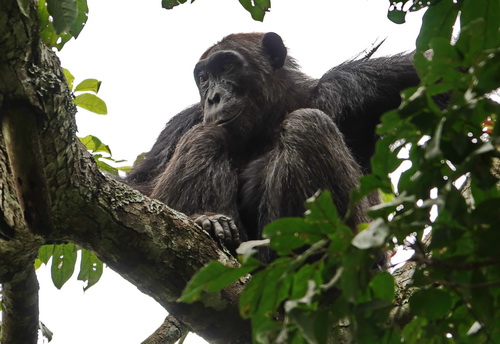
Kyambura is the only place in QEPA where habituated chimpanzees are seen. Other types of primates include red-tailed monkey, black-and-white colobus, baboons and vervet monkeys. The park is also known for its variety of avian species including various falcons, the blue-headed bee-eater and the African finfoot. The chimpanzees in Kyambura Gorge were isolated after the forests connecting it to larger forests like Kalinzu and Maramagambo were cleared. [5] [ better source needed ] Conservationists are worried that this could lead to inbreeding and mutations. [5] While tracking chimps, visitors are treated to views of the "underground forest" (the forest growing in the gorge), birds and smaller primates. [1] [6]
Virunga National Park is a national park in the Albertine Rift Valley in the eastern part of the Democratic Republic of the Congo. It was created in 1925. In elevation, it ranges from 680 m (2,230 ft) in the Semliki River valley to 5,109 m (16,762 ft) in the Rwenzori Mountains. From north to south it extends approximately 300 km (190 mi), largely along the international borders with Uganda and Rwanda in the east. It covers an area of 8,090 km2 (3,120 sq mi).
The Bwindi Impenetrable National Park is a national park in southwestern Uganda. It is part of the Bwindi Impenetrable Forest and is situated along the Democratic Republic of the Congo border next to the Virunga National Park and on the edge of the Albertine Rift. Composed of 321 km2 (124 sq mi) of both lowland and montane forest, it is accessible only on foot. It is a United Nations Educational, Scientific and Cultural Organization-designated World Heritage Site.
Queen Elizabeth National Park is a national park in the Western Region of Uganda.
Kibale National Park is a national park in western Uganda, protecting moist evergreen rainforest. It is 766 square kilometres (296 sq mi) in size and ranges between 1,100 metres (3,600 ft) and 1,600 metres (5,200 ft) in elevation. Despite encompassing primarily moist evergreen forest, it contains a diverse array of landscapes. Kibale is one of the last remaining expanses to contain both lowland and montane forests. In eastern Africa, it sustains the last significant expanse of pre-montane forest.
The Nyungwe Forest is located in southwestern Rwanda, on the border with Burundi, where it is contiguous with the Kibira National Park to the south, and Lake Kivu and the Democratic Republic of the Congo to the west. The Nyungwe rainforest is probably the best preserved montane rainforest in Africa. It is located in the watershed between the basin of the Congo River to the west and the basin of the river Nile to the east. From the east side of the Nyungwe forest comes also one of the branches of the Nile sources.
Outamba-Kilimi National Park is located in north-west Sierra Leone near the border with Guinea. The park is divided into two areas, Outamba (741 km2) and Kilimi (368 km2). The park is named after its highest peak in one part, Mount Outamba, and its longest river in the other, River Kilimi.
Rwenzori Mountains National Park is a Ugandan national park and UNESCO World Heritage Site located in the Rwenzori Mountains. Almost 1,000 km2 (386 sq mi) in size, the park has Africa's third highest mountain peak and many waterfalls, lakes, and glaciers. The park is known for its beautiful plant life.
Mgahinga Gorilla National Park is a national park in southwestern Uganda. It was created in 1991 and covers an area of 33.9 km2 (13.1 sq mi).
The Northern Congolian forest–savanna mosaic is a forest and savanna ecoregion of central Africa. It extends east and west across central Africa, covering parts of Cameroon, Central African Republic, Democratic Republic of the Congo, South Sudan, and Uganda. It is part of the belt of transitional forest-savanna mosaic that lie between Africa's moist equatorial Guineo-Congolian forests and the tropical dry forests, savannas, and grasslands to the north and south.
The Albertine Rift montane forests is a tropical moist broadleaf forest ecoregion in east-central Africa. The ecoregion covers the mountains of the northern Albertine Rift, and is home to distinct Afromontane forests with high biodiversity.
The wildlife of Ivory Coast consists of the flora and fauna of this nation in West Africa. The country has a long Atlantic coastline on the Gulf of Guinea and a range of habitat types. Once covered in tropical rainforest, much of this habitat has been cleared, the remaining terrain being gallery forests and savanna with scattered groups of trees, resulting in a decrease in biodiversity. As of 2016, 252 species of mammal had been recorded in Ivory Coast, 666 species of bird, 153 species of reptile, 80 species of amphibian, 671 species of fish and 3660 species of vascular plant.
The wildlife of Uganda is composed of its flora and fauna. Uganda has a wide variety of different habitats, including mountains, hills, tropical rainforest, woodland, freshwater lakes, swamps and savanna with scattered clumps of trees. The country has a biodiverse flora and fauna reflecting this range of habitats and is known for its primates, including gorillas and chimpanzees. There are ten national parks and thirteen wildlife reserves; some 345 species of mammal and 1020 species of bird have been recorded in the country.
Damaliscus lunatus jimela is a subspecies of topi, and is usually just called a topi. It is a highly social and fast type of antelope found in the savannas, semi-deserts, and floodplains of sub-Saharan Africa.
The Bwindi Impenetrable Forest is a large primeval forest located in south-western Uganda and is located in three districts of Kisoro, Kabale and Kanungu. The Bwindi forest is on the edge of the Albertine Rift, the western branch of the East African Rift, at elevations ranging from 1,160 to 2,607 metres. The forest contains around 160 species of trees and over 100 species of ferns. Bwindi Impenetrable Forest Reserve was set up in 1942 on the rim of the Rift Valley.
The national parks of Rwanda are protected ecosystems and wildlife reserves located within the borders of Rwanda in east central Africa. In 2020, these protected natural zones include the Volcanoes National Park, Akagera National Park and Nyungwe Forest. Maintenance of the national park system, as well as tourism infrastructure and promotion of the parks, is managed by the Rwanda Development Board (RDB) with assistance from government ministries.
Maramagambo Forest is located in Bushenyi, Uganda. It is one of the enormous forests in Eastern Africa. It adjoins the Queen Elizabeth National Park to the north. It is jointly managed by the Uganda Wildlife Authority and the National Forestry Authority.
The Semliki Wildlife Reserve is a conservation protected area in the Western Region of Uganda with headquarters at Karugutu in Ntoroko District.It is the oldest wildlife reserve.
Kalinzu Central Forest Reserve is a protected area located in Bushenyi district in south-western Uganda. Covering an area of 137 square kilometers, the reserve is characterized by its diverse ecosystem consisting of dense tropical rainforest vegetation and a wide range of wildlife.
Kasyoha-Kitomi Forest Reserve is located in Western Uganda, 35 kilometers from Bushenyi Town, South of Lake George and the Kazinga Channel, and covers an area of 433 square kilometers along the South of Lake George and Kazinga channel in the Albertine region. The reserve is situated in the administrative districts of Bushenyi, Rubirizi, Ibanda and Kamwenge.
Kasyoha-Kitomi Central Forest Reserve is located in Western Uganda, and has an area of 433-square-kilometre (107,000-acre). It is located south of Lake George and the Kazinga channel in the Albertine Rift eco-region, which is known for its abundance of endemic species. The forest reserve lies within the counties of Bunyaruguru, Igara and Buhweju in the administrative districts of Bushenyi, Ibanda and Kamwenge It was officially gazetted in 1932 and is controlled by Uganda's National Forestry Authority (NFA).