
Darchula District is one of the nine districts of Sudurpashchim Province. The area, with Khalanga as its capital, covers an area of 2,322 km2 (897 sq mi) and has a population (2011) of 133,274. Darchula lies in the west-north corner of the country.

Dhading District, a part of Bagmati Province, is one of the seventy-seven districts of Nepal. The district, with Dhading Besi as its district headquarters, covers an area of 1,926 square kilometres (744 sq mi), had a population of 338,658 in 2001 and 336,067 in 2011.

Dolpa District, is a district, located in Karnali Province of Nepal, It is one of the seventy-seven districts of Nepal and one of ten district of Karnali. The district, with Dunai as its district headquarters, covers an area of 7,889 km2 (3,046 sq mi) and has a population (2023) of 43,000. Dolpa is the largest district of Nepal in terms of area.
Gorkha District, a part of Gandaki Province, is one of 77 districts of Nepal, and the fourth largest district of the country in terms of area. It is historically linked with the creation of modern Nepal and the name of the legendary Gorkha soldiers. The district, with Gorkha Municipality as its district headquarters, covers an area of 3,610 km2 (1,390 sq mi) and has a population of 252,201, according to the 2021 Nepal census. Gorkha district is the site of the Manakamana Temple, as well as Gorakhnath and Gorakh Kali temples. Several major rivers—including the Chepe, Daraudi, Marsyangdi, Budi Gandaki, and Trishuli—run through the district.

Kaski District, a part of Gandaki Province, is one of the seventy-seven districts of Nepal. The name is disambiguated from Kaskikot, the ancient Kaski Kingdom.

Kavrepalanchok District is one of the 77 districts of Nepal. The district, with Dhulikhel as its district headquarters, covers an area of 1,396 km2 (539 sq mi). It is a part of Bagmati Province and has a population of 364,039.

Nawalparasi District, part of which belongs to Gandaki Province and part to Lumbini Province, was one of the 75 districts of Nepal before being divided into Parasi District and Nawalpur District in 2015.

Saptari, a part of Madhesh Province, is one of the seventy-seven districts of Nepal. Its district headquarter is Rajbiraj. Saptari is an Outer Terai district. This district covers an area of 1,363 km2 (526 sq mi) and has a population (2011) of 639,284 which makes it the 10th most populated district of Nepal. Saptari is renowned for its agricultural output, and is bordered on the east by the massive Sapta Koshi river.

Solukhumbu District (Nepali: सोलुखुम्बु जिल्ला, Sherpa: ཤར་ཁུམ་བུ་རྫོང་།, Wylie: shar khum bu dzong) is one of 14 districts of Koshi Province of eastern Nepal. As the name suggests, it consists of the sub-regions Solu and Khumbu. The closest post office to Solukhumbu with a postal code assigned to it is the Sindhuli D.P.O., which has the postal code 56000.

Taplejung District is one of 77 districts of Nepal and one of the 14 districts of Koshi Province. It is located deep in the Himalayas in Eastern Nepal with བོད to the north across the Himalayas. Taplejung is the third largest district of Nepal.
Pyuthan is a municipality in the Pyuthan District in the Lumbini Province of Nepal. This municipality is named after the district name Pyuthan. It is also the major market center and the administrative center of district. The municipality was established on 18 May 2014 by merging the existing VDCs Khaira, Dakha Kwadi, Bijaya Nagar, Bijuwar, Dharmawati, Maranthana and Khalanga village development committees. In 2017, when GoN restructured the local level bodies into 753 units, Pyuthan Municipality was also restructured excluding ward no. 1, 2, 3, 5 and 18 from old structure, further two other VDCs; Majhkot and Jumrikanda added, Khalanga separated and managed the municipality into 10 new wards. Nayabajar Jumri and Bijuwar are the major markets of Pyuthan Municipality.

Sandakphu or Sandakpur is a mountain peak in the Singalila Ridge on the border between India and Nepal. It is the highest point of the ridge and of the state of West Bengal, India. The peak is located at the edge of the Singalila National Park and has a small village on the summit with a few hotels. Four of the five highest peaks in the world, Everest, Kangchenjunga, Lhotse and Makalu can be seen from its summit. It also affords a pristine view of the entire Kangchenjunga Range. Sandakphu is also known as the land of poisonous flowers.
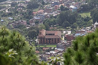
Dhulikhel is a municipality in Kavrepalanchok District of Nepal. Two major highway B.P. Highway and Araniko Highway passes through Dhulikhel. Araniko Highway connects Kathmandu, Nepal's capital city with Tibet's border town of Kodari. Dhulikhel is located at the Eastern rim of Kathmandu Valley, south of the Himalayas at 1550m above sea level and is situated 30 km southeast of Kathmandu and 74 km southwest of Kodari. The Majority of people in Dhulikhel are Newars, and Brahmin, Chhettri, Tamang and Dalit are also living in outer area of the town. Drinking water in Dhulikhel is some of the best water in Nepal. It was made with the help of the German NGO German Technical Cooperation.

Solududhkunda (earlier:Dudhkunda) is the only municipality of Solukhumbu District. Located in Koshi Province of Nepal. The town of Salleri, which is located within the municipality is the headquarter of Solukhumbu District It was formed in 2014 by merging four VDCs: Salleri, Garma, Loding Tamakhani and Beni and was divided into 9 wards. Total area of the municipality had 254.3 square kilometres (98.2 sq mi) and population of municipality had 20,399 individuals living in 5,368 households.

Ghandruk is a Village Development Committee in the Kaski District of the Gandaki Province of Nepal. Situated 32 km north-west to Pokhara, the village is readily accessible by public buses and private taxis from the provincial headquarter. At the time of the 1991 Nepal census, it had a population of 4,748 residents in 1,013 individual households.
Godawari is a municipality in Lalitpur District in Bagmati Province of Nepal. It was established on 2 December 2014 by merging the former Village development committees Godawari, Badikhel, Bisankhunarayan, Godamchaur and Thaiba of Lalitpur District of Bagmati Zone. The municipality area was again expanded in March 2017 to include in total 12 previous VDCs. The six VDCs added were Devichaur, Dukuchhap, Chhampi, Thecho, Chapagaun, Jharuwarasi and Lele. The centre of this municipality is located at Bajrabarahi.

The 2017 Nepalese local elections were held in Nepal in three phases on 14 May, 28 June and 18 September in 6 metropolitan cities, 11 sub-metropolitan cities, 276 municipalities and 460 rural municipalities. It was the first local level election to be held since the promulgation of the 2015 constitution.

A municipality in Nepal is an administrative division in the Provinces of Nepal. The urban population of Nepal refers to the inhabitants residing in the designated municipal area. Population size has been taken as the principal criteria in the declaration of urban areas in Nepal since 1961. Municipalities can therefore also include rural areas. It functions as a sub-unit of a district. Nepal currently has 293 municipalities, which given the 2011 population estimate of 16,656,057.
Chankheli is a rural municipality located in Humla District of Karnali Province of Nepal.
Temal is a Rural municipality located within the Kavrepalanchowk District of the Bagmati Province of Nepal. The municipality spans 88.85 square kilometres (34.31 sq mi) of area, with a total population of 16,957 according to a 2021 Nepal census.

