Saping

Last updated
Saping
सापिङ
Saping Dadatol.jpg
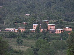
Saping village before 2015 Earthquake
Nepal adm location map.svg
Red pog.svg
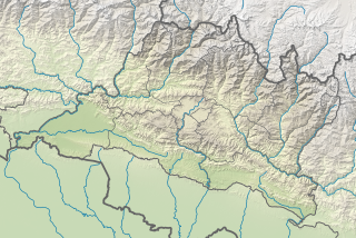
Saping
Location in Nepal
Coordinates: 27°40′N85°45′E / 27.66°N 85.75°E / 27.66; 85.75 Coordinates: 27°40′N85°45′E / 27.66°N 85.75°E / 27.66; 85.75
Country Nepal
Province Bagmati Province
District Kabhrepalanchok District
Population
 (2011)
  Total3,246
Time zone UTC+5:45 (Nepal Time)

Saping is a sparsely populated village in Kabhrepalanchok district, about 60 kilometres east of Kathmandu, Nepal. As of 2011 census, Saping village has 786 households with 3,246 individuals, 1,472 males and 1,774 females (CBS Nepal 2012), and under the "new" federal structure, formed by a new constitution, adopted on 20 September 2015, Saping is now a part of Bhumlu Gaupalika (in English: Bhumlu Rural Municipality) and is organized as Ward Number 1 (out of 10 small government units called 'wards', cf. in the pre-2015 era the village was called Saping Village Development Committee [1] ).

As a mixed ethnic and linguistic community, Saping has several well known travel destinations, including holy sites like Mulkharka Bhimsenthan and Saping Siddhi Ganesh Temple - both of which can be reached using vehicles or on foot from Dolalghat town, as a part of a (day or two) trekking adventure. [2] [3]

In terms of geography, Saping consists largely of a rough hill terrain, with a few patches of semi-flat land here and there; its height ranges from 633 meters at Dolalghat Sukhoshi river, 1,366 meters at Saping Siddhi Ganesh Temple (Ramche), to 1,805 meters at Mulkharka Bhimsenthan. Because of its rugged landscape and varied altitude, the climate system also varies in Saping, from subtropical jungle along the Sunkoshi river banks to temperate forest around Mulkharka Bhimsenthan.

The main source of income in Saping is agriculture, but in the recent years, the vast majority of young people have migrated to the cities, and many to foreign countries, especially to Arab countries in the Middle East, and Malaysia. As such, the remittances sent through foreign labour has become the primary source of livelihood for virtually all families. This has led to a rapid decline in agriculture as economically active population has largely moved out of the village. Elders are worried that unless the local and central governments make concerted efforts to keep (i.e. attract back) young people in the village, it appears likely that the village might rapidly lose its population and thereby risking its importance.

In Saping, the basic infrastructure such as road, electricity, water supply, etc. is still in a primitive state. There is a newly opened ruggy track from Silame Bhir (just above Sunkoshi river banks at Dolaghat [4] ), which is gradually being upgraded, but as of 2020 it is not yet clear how far this road network will be developed and whether it will be linked to other long routes in the surrounding districts of Sindhupalchok, Dolakha, Ramechhap, etc. Electricity has reached the villagers and as of February 2020 wooden poles have been upgraded with metal ones, making it a bit better lasting in the years ahead.

Especially after the devastating earthquakes of 2015, water supply has become one of the major concerns because many of the natural spring water sources have disappeared, but the villagers have been working on to bring piped water from far away sources.

There is a small health post nearby Lakuri Danda, where also Saping's (i.e. ward number one's) government unit is located, which was built during the post-2015 earthquakes reconstruction. Furthermore, the village has two secondary schools, one at Lakuri Danda, and other at Ritthe where students can finish their high school (i.e. 12 years of education). So far there is no legal agency or security police presence in the village.

In spite of being quite close to the Kathmandu valley, Saping remained largely backward. Only in the recent years, Sapingeli are becoming more hopeful because the first elected federal government (since 2018) has tried to allocate a sizable annual budget to develop rural governance and infrastructure.

Related Research Articles

Banepa Municipality in Bagmati Province, Nepal

Banepa, a municipality and historical town is a valley situated at about 1,500 m (4,900 ft) above sea level in central Nepal which is at about 25 kilometres (16 mi) east from Kathmandu. At the time of the 2011 Nepal census, it has a population of 55,528. The main attraction of Banepa is the temple of Chandeshwori, located approximately 1 km (0.62 mi) northeast of the town along the Rudramati River. The Dhaneshwor Temple is 1 km south of the town. Banepa is also known for its eight different temples of Lord Ganesh, Narayanthan, Bhimshenthan and eight different ponds.

Kavrepalanchok District District in Bagmati Province, Nepal

Kavrepalanchok District, simply known as Kavre, is one of the 77 districts of Nepal, The district, with Dhulikhel as its district headquarters, covers an area of 1,396 km2 (539 sq mi). It is a part of Bagmati Province and has a population of 381,937.

Sindhupalchowk District District in Bagmati Pradesh, Nepal

Sindhupalchowk District is a part of Bagmati Province and one of the seventy-seven districts of Nepal, with an area of 2,542 km2 (981 sq mi). The district's headquarters is in Chautara. In 2006, 336,478 people resided in 79 village development committees, in 2011 there were 287,798.

Chabahil City in Bagmati Province, Nepal

Chabahil is an ancient neighborhood in northeast Kathmandu in Nepal. It is famous for its Licchavi stupa, called the Dhando Chaitya, considered by many historians to be the oldest Buddhist Stupa in the valley. Currently, Chabahil has become a thriving residential and commercial area of Kathmandu. Two of the most important temples in Kathmandu, Pashupatinath and Guhyeswari are situated very close to Chabahil. These two temples, dedicated to Lord Shiva and his consort Sati are considered to be more than a thousand years old.

Bharatpur, Nepal Metropolitan City in Bagmati Province, Nepal

Bharatpur is a city in southern central Nepal with a population of 280,502. It is the second largest metropolitan city in Nepal by area, the fourth largest metropolitan city by population, and also the district headquarter of the Chitwan District.

Dhulikhel Municipality in Kavrepalanchowk District of Nepal

Dhulikhel is a municipality in Kavrepalanchok District of Nepal. Two major highway B.P. Highway and Arniko Highway passes through Dhulikhel. Araniko Highway connects Kathmandu, Nepal's capital city with Tibet's border town of Kodari. Dhulikhel is located at the Eastern rim of Kathmandu Valley, south of the Himalayas at 1550m above sea level and is situated 30 km southeast of Kathmandu and 74 km southwest of Kodari. The Majority of people in dhulikhel is Newars, and Brahmin, Chhettri, Tamang and Dalit are also living in outer area of the town. Drinking water in Dhulikhel is some of the best water in Nepal. It was made with the help of the German NGO, German Technical Cooperation.

Birendranagar Sub-Metropolitan City in Karnali Province, Nepal

Birendranagar officially Birendranagar Sub-Metropolitan city is a city in Surkhet District in Karnali province of Nepal.

Ghorahi Sub-Metropolitan City in Lumbini Province, Nepal

Ghorahi is the seventh largest city and largest sub-metropolitan city of Nepal. The city lies in Lumbini Province in the mid-Western part of Nepal. It is the largest city of Dang Deukhuri District of southwest Nepal. Located in the Inner Terai region, it lies 413 kilometres (257 mi) south-west of Nepal's capital Kathmandu and is one of the Counter Magnets being developed as an alternative centre of growth to help ease the migration and population explosion in the Kathmandu metropolitan area. It is the largest city of the Rapti Zone and is surrounded by the Sivalik Hills to the south and Mahabharata Range to the north.

Besisahar Municipality in Gandaki Province, Nepal

Besishahar is a municipality and the district headquarters of Lamjung District in Gandaki Province, Nepal. The Besishahar Municipality was formed by merging the existing Village Development Committees i.e. Besishahar, Gaunshahar, Udipur, Chandisthan, Baglungpani, Bajhakhet, Hiletaksar and Chiti and have 11 wards. Here are different castes and religions. So they have different culture. This municipality has a sub-tropical climate with deciduous forests. Annapurna II, Machhapuchhre, Lamjung Himal can be viewed from north of Besishahar Municipality.

Madhyapur Thimi Municipality in Bagmati Province, Nepal

Madhyapur Thimi, also known as Thimi, is a municipality in Bhaktapur District in the Bagmati Zone of central Nepal. Thimi lies between Kathmandu, Lalitpur and Bhaktapur in the Kathmandu Valley. It is one of the ancient cultural and historical places along the trade route from Bhaktapur to Kathmandu. The city is situated on elevated land and occupies an area of 11.47 square kilometres (4.43 sq mi), divided into nine administrative wards.

Daanchhi Village of Kageshwari-Manohara Municipality in No. 3, Nepal

Danchhi is a village and former Village Development Committee that is now part of Kageshwari-Manohara Municipality in Kathmandu District in Province No. 3 of central Nepal. At the time of the 2011 Nepal census, it had a population of 11,246 and had 2,593 households in it. Danchhi is now included in Kageswori Manohara Municipality. Danchhi/Thali is bounded by Bagmati and Manohara river. The major places include Thali/थली, Nayapati, Bhadrawas, Hariyalinagar, Dumakhal, and Gajarkot. The major government schools are Shree Sahid Aadarsha Uchha MaVi, Shree Kanti Bhairab MaVi, and Shree Chaulanarayan PraVi. Private schools include Miniland English High School, Mount Everest Secondary School, Pragya Sadan School, Alpine Academy, and Hindu Vidhya Peeth.

Sundarijal Village of Gokarneshwar Municipality in No. 3, Nepal

Sundarijal is a village and former Village Development Committee that is now part of Gokarneshwar Municipality in Kathmandu District in Province No. 3 of central Nepal.

Patan Durbar Square

Patan Durbar Square is situated at the centre of the city of Lalitpur in Nepal. It is one of the three Durbar Squares in the Kathmandu Valley, all of which are UNESCO World Heritage Sites. One of its attractions is the ancient royal palace where the Malla Kings of Lalitpur resided.

Maula Kalika Temple

Maula Kalika is a famous Hindu temple of Goddess Kalika in Gaindakot town of Nawalpur district in Gandaki province of Nepal.

Gaindakot Municipality Municipality in Gandaki Province, Nepal

Gaindakot is a municipality in Nawalpur District in the Lumbini Zone of southern Nepal. It became a municipality in May 2014 by merging the existing Mukundapur, Amarapuri, and Gaindakot VDCs. It was again expanded by merging Ratanpur VDC. It is situated on the shore of Narayani River in the lap of Maula Kalika temple. So this place has a great possibility of tourism development. At the time of the 2011 Nepal census, it had a population of 58,841 and 13,623 individual households according to 2011 Nepal census.

2014 Sunkoshi blockage

On 2 August 2014, due to heavy rainfall, a landslide occurred at the Sunkoshi river, killing 156 people and blocking the river to form an artificial lake in Sindhupalchok District, Nepal. Araniko Highway, the main artery of goods and people flow to China, was blocked by the landslide ripping out 5 km of highway, and causing huge traffic jam. 2 dozens houses have been swept by the landslide. The landslide had a volume of 5.5 million cubic metres.

Siddhikali Temple

Siddhikali Temple is a Hindu temple located in Thimi, Nepal. The two storeys roofed temple is dedicated to Lord Kali, Shiva and Ganesh. It is also believed that this Shaktipeeth is formed due to the falling of right eye of the corpse of Sati. This place is located in Inayekwo, in the north west of Thimi. The temple is also known as Inayekwo Dyo in Nepal Bhasa language. And Siddhikali Temple is also known as Chamunda, one of the goddess of Astamatrika. The majestically impressive Siddhikali temple has numbers of Pataa streaming down the front. There's a Satah (rest-house) opposite to temple and multiple Falcha (Inns) and several smaller shrines to the rear and nearby and several stone taps around the place. The artwork around the Siddhikali temple is fantastic and worth a close inspection.

Khotehang Rural Municipality Rural Municipality in Province No. 1, Nepal

Khotehang is a rural municipality (gaunpalika) in Khotang District of Province No. 1 of Nepal.

Bhumlu Rural Municipality Rural Municipality in Bagmati, Nepal

Bhumlu is a Rural municipality located within the Kavrepalanchowk District of the Bagmati Province of Nepal. The municipality spans 91 square kilometres (35 sq mi) of area, with a total population of 18,916 according to a 2011 Nepal census.

References

  1. "Nepal Census 2001". Nepal's Village Development Committees. Digital Himalaya . Retrieved 3 September 2008.
  2. "Saping Siddhi Ganesh Temple". sapingsiddhiganeshtemple.blogspot.nl. Retrieved 26 April 2018.
  3. "Saping Tourism". Saping Siddhi Ganesh Temple. Ramche Saping 1 . Retrieved 16 February 2018.
  4. "Adventure Dolalghat". Dolalghat tour. Adventure Travel . Retrieved 15 September 2020.