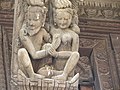
In Hinduism, Ahalya also known as Ahilya, is the wife of the sage Gautama Maharishi. Many Hindu scriptures say that she was seduced by Indra, cursed by her husband for infidelity, and liberated from the curse by Rama.

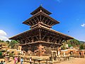
Banepa, a municipality and historical town is a valley situated at about 1,500 m (4,900 ft) above sea level in central Nepal which is at about 25 kilometres (16 mi) east from Kathmandu. At the time of the 2011 Nepal census, it has a population of 55,528. The main attraction of Banepa is the temple of Chandeshwori, located approximately 1 km (0.62 mi) northeast of the town along the Rudramati River. The Dhaneshwor Temple is 1 km south of the town. Banepa is also known for its eight different temples of Lord Ganesh, Narayanthan, Bhimshenthan and eight different ponds.

Kavrepalanchok District, simply known as Kavre, is one of the 77 districts of Nepal, The district, with Dhulikhel as its district headquarters, covers an area of 1,396 km2 (539 sq mi). It is a part of Bagmati Province and has a population of 381,937.

Parbat District (Nepali: पर्वत जिल्ला[pʌɾbʌt], is a hilly area of Nepal. It is a part of Gandaki Province and one of the seventy-seven districts of Nepal. The district, with Kusma as its district headquarters, covers an area of 494 km2 and has a population of 157,826. It is the fourth smallest district of Nepal with 47 VDCs currently. It is mainly known for the Gupteshwar Cave, which is visited by thousands of pilgrims during Shivaratri. Patheshwari Temple a notable temple in Kushma located at Katuwa Chaupari of Kushma-09. Patheshwori Mandir has many sub-temples inside like Ram Janaki Mandir, Bhagwati, Devi, Hanuman, and others. Alapeshwar cave is a cave in this district. It is also noted for the Dahere Deurali Temple, which is visited by thousands of pilgrims during Balachaturdanshai. Kamadhenu Mandir is another temple of Parbat district which is located in Khurkot development committee. Recently the Modi hydro project of 10 M.W. has been constructed in this district. Parbat's biggest playground lies in Phalewas village named Majhi Chour and Indra Chour.

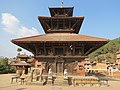
Panauti is a municipality in Kavrepalanchok District in Bagmati Province of Nepal located 32 km Southeast of the capital Kathmandu. The town is currently listed as a UNESCO tentative site since 1996.
Dhulikhel is a municipality in Kavrepalanchok District of Nepal. Two major highway B.P. Highway and Arniko Highway passes through Dhulikhel. Araniko Highway connects Kathmandu, Nepal's capital city with Tibet's border town of Kodari. Dhulikhel is located at the Eastern rim of Kathmandu Valley, south of the Himalayas at 1550m above sea level and is situated 30 km southeast of Kathmandu and 74 km southwest of Kodari. The Majority of people in dhulikhel is Newars, and Brahmin, Chhettri, Tamang and Dalit are also living in outer area of the town. Drinking water in Dhulikhel is some of the best water in Nepal. It was made with the help of the German NGO, German Technical Cooperation.
Rangeli is a Municipality and rural market town in Morang District in the Koshi Zone of south-eastern Nepal. This municipality was formed merging existing four villages i.e.Amgachhi, Babiabirta, Darbesa and Rangeli itself since May 2014.

Matatirtha is a village and former Village Development Committee that is now part of Chandragiri Municipality in Kathmandu District in Province No. 3 of central Nepal. At the time of the 1991 Nepal census it had a population of 2,799 living in 506 households. Its population has now grown to 5,982 spread over 1,314 households. Santosh Khadka was elected as Ward Chairman of Matatirtha through a local election.
Dhanushadham is a municipality in Dhanusha District in Province No. 2 of south-eastern Nepal. The municipality was established on 18 May 2014 by merging the existing Govindapur, Umprempur, Yagyabhumi, Dhanushadham village development committees (VDCs). It is a religious place of Hindu worship in Nepal. It is believed that a part of Shiva Dhanusha that was broken by Rama during Sita's swayamvara, is housed. Now there is temple around the remaining of bow and visited by Hindu devotees from all over the world. That's why it is named Dhanushadham.
Mukhiyapatti Musharniya is a village development committee in Dhanusa District in Province No. 2 of south-eastern Nepal. At the time of the 1991 Nepal census it had a population of 4,621 people living in 436 individual households.
Amlekhganj (Nepali:अमलेखगंज) is a town and Village Development Committee in Bara District in the Narayani Zone of south-eastern Nepal. At the time of the 2011 Nepal census it had a population of 6,709 people living in 1370 individual households. There were 3,413 males and 3,296 females at the time of census. At one time it was famed as the starting point of the Nepal Government Railway (NGR) which connected it with Raxaul in India.
Kalika is a town and Village Development Committee in Kaski District in the Gandaki Zone of northern-central Nepal. At the time of the 1991 Nepal census it had a population of 4,688 persons living in 949 individual households.
Ghyang Sukathokar is a village development committee (VDC) in Dolakha District in the Janakpur Zone of north-eastern Nepal. At the time of the 1991 Nepal census it had a population of 4,600.
Sunakhani is a village development committee in Dolakha District in the Janakpur Zone of north-eastern Nepal. Under the new geographical structure, Sunkhani is a village of Kalinchwok Gaun Palika.
Bhadsar is a village development committee in Sarlahi District in the Janakpur Zone of south-eastern Nepal. At the time of the 1991 Nepal census it had a population of 2,950 people living in 499 individual households.
Jamuniya is a village development committee in Sarlahi District in the Janakpur Zone of south-eastern Nepal. At the time of the 1991 Nepal census it had a population of 5,399 people living in 914 individual households.
Madar, Nepal is a village development committee in Siraha District in the Sagarmatha Zone of south-eastern Nepal. At the time of the 1991 Nepal census it had a population of 7247 people living in 1203 individual households, with the local Maithali language. Had one health post with minimum facility. Temples are Shree Mata Durga Bhagabati, Shree Mmata Kali, the oldest one shree ramjanki temple. This VDC is situated beside borderline of India.
Tikhatar is a village development committee in Doti District in the Seti Zone of western Nepal. At the time of the 1991 Nepal census it had a population of 5222 people in 958 individual households.

Letang, "लेटाङ " is a Municipality in Morang District in the Province No. 1 of south-eastern Nepal. It was formed by merging the existing Village Development Committees of Letang, Jante, Warrangi and Bhogateni.
Edited by ABHASH

Suryabinayak Municipality is a municipality in Nepal that was created in December 2014 through the merger of the Village development committees of Kautunje, Sipadol, Nankhel and Chitpol. The municipality's name stems from the local Suryavinayak Temple. In March 2017, under new local level restructuring, Suryabinayak Municipality was expanded to include the neighboring municipality of Anantalingeshwor, adding four more previous VDCs of Sirutar, Gundu, Dadhikot and Balkot. According to the 2011 Nepal census, the predecessors of Suryabinayak Municipality had a population of 78,490.