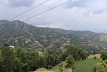
Jiri is a municipality in Dolakha District in the Bagmati Province of central Nepal. At the time of the 2011 Nepal census it had a population of 13,638 people. Jiri, which lies about 190 kilometers from Kathmandu, is the main gateway to the Everest Region. Almost all the Everest expeditions, including the one led by famous climber John Hunt, Edmund Hillary had passed through Jiri. A company of the Nepal Army is stationed in town and visitors' equipment and backpacks might be searched. There are a number of lodges available along either side of the main road mainly in Jiri Bazaar.

Banepa is a municipality and historical town in a valley situated at about 1,500 m (4,900 ft) above sea level in central Nepal which is at about 25 kilometres (16 mi) east from Kathmandu. At the time of the 2011 Nepal census, it has a population of 55,528. The main attraction of Banepa is the temple of Chandeshwori, located approximately 1 km (0.62 mi) northeast of the town along the Rudramati River. The Dhaneshwor Temple is 1km south of the town. Banepa is also known for its eight different temples of Lord Ganesh, Narayanthan, Bhimshenthan and eight different ponds.

Kavrepalanchok District is one of the 77 districts of Nepal. The district, with Dhulikhel as its district headquarters, covers an area of 1,396 km2 (539 sq mi). It is a part of Bagmati Province and has a population of 381,937.
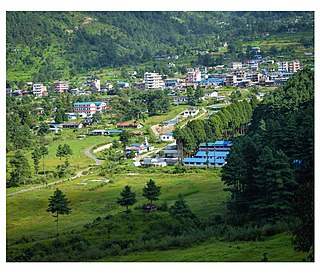
Dhulikhel is a municipality in Kavrepalanchok District of Nepal. Two major highway B.P. Highway and Araniko Highway passes through Dhulikhel. Araniko Highway connects Kathmandu, Nepal's capital city with Tibet's border town of Kodari. Dhulikhel is located at the Eastern rim of Kathmandu Valley, south of the Himalayas at 1550m above sea level and is situated 30 km southeast of Kathmandu and 74 km southwest of Kodari. The Majority of people in Dhulikhel are Newars, and Brahmin, Chhettri, Tamang and Dalit are also living in outer area of the town. Drinking water in Dhulikhel is some of the best water in Nepal. It was made with the help of the German NGO German Technical Cooperation.

Besishahar is a municipality and the district headquarters of Lamjung District in Gandaki Province, Nepal. The Besishahar Municipality was formed by merging the existing Village Development Committees i.e. Besishahar, Gaunshahar, Udipur, Chandisthan, Baglungpani, Bajhakhet, Hiletaksar and Chiti and have 11 wards. This municipality has a sub-tropical climate with deciduous forests. Annapurna II, Machhapuchhre, Lamjung Himal can be viewed from north of Besishahar Municipality.

Bhimeshwar,, is a municipality in north-eastern Nepal and the headquarters of Dolakha District in Bagmati Province that was established in 1997 by merging the former Village development committees Charikot, Dolakha Town, Makaibari and Mati. At the time of the 2011 Nepal census it had a population of 32,486 people living in 8,639 individual households. The town is located at an altitude of 1554 metres (5101 feet). The name of the district Dolakha came from Dolakha Town situated north-east of the headquarters Charikot Bazaar.
Kailashmandau used to be VDC in Bajura District in the Seti Zone of north-western Nepal. At the time of the 2011 Nepal census it had a population of 9,586 and had 1818 houses. There is a small market and it is also the junction to many villages of this region.
Jhor Mahankal is a village and former village development committee which is part of the Tokha municipality in Kathmandu District, Bagmati Province of central Nepal. It had a population of 4,103 in the 2011 Nepal census, with 873 households. Jhor Mahankal is known for Baruneshwar Gufa and its waterfalls. A number of clans live there, primarily the Adhikaris, Lamichanne, Dulals, Bidari, and Tamang. Jhor Mahankal is 7 kilometres (4.3 mi) from Kathmandu, with bus service from the Jhor bus station to Simalchour Syampati and Samakhushi and Ratna Park in Kathmandu.
Kavre Nitya Chandeswori popularly known as "Kavre" is a village development committee in Kavrepalanchok District in the Bagmati Zone of central Nepal. Two of its V.D.C's are included in Dhulikhel Municipality in the year 2015 A.D. At the time of the 2011 Nepal census it had a population of 4,927 in 1,042 individual households.
Puranchaur is a former Village Development Committee in Kaski District in the Gandaki Province of northern-central Nepal. It is now annexed to Pokhara metropolitan city, and is ward no. 19 of it. At the time of the 2011 Nepal census it had a population of 3,597 persons living in 865 individual households.
Saimarang is a town and Village Development Committee in Kaski District in the Gandaki Province of Western Nepal. At the time of the 2011 Nepal census it had a population of 1,171 persons living in 309 individual households. Saimarang owns a famous Temple Bhagawati Temple and hill known as Lamtari there is a famous Devi tample called Lamtari Mai which is in front of Pokhara Valley. The Annapurna Himalayan range can be seen at the back of the village, and Begnash, Rupa and Fewa lake in the front. Also there are several adventures such as caves, rocky hills. Local people in Warchowk and Togi are working hard to make the Saimarang VDC a good place for Adventurous Tourism. The people there are very helpful.
Chhatiwan is a Village Development Committee in Doti District in the Seti Zone of western Nepal. At the time of the 1991 Nepal census it had a population of 3000 residing in 478 individual households. The name for this VDC comes from a lake that is situated in the village of Chhatiwan. This lake has fresh drinking water and teamed with various kind of fish. Lately due to the deforestation and soil erosion, this lake is being filled with all debris coming in due to the flash flood from its North side of the mountain. Budar is the major town of this VDC and at this town Dadeldhura and Jogbuda roads cross. Some of the major villages in this VDC are Budar, Ritha, Phaltude, Dharapani, Chhatiwan, Chhahara and many others. There are two small mountain streams that eventually meet up at Deujaal. A stream that comes from the Chhahara village has a wonderful water fall. The name of the water fall itself is Chhahara. In Nepali "Chhahara" means water fall. Once in a year there is a special festival at the foot of this water fall where people from many surrounding villages come and celebrate throughout the night. The festival begins in the evening and people sing, dance and merry all through the night. This is also the night when lovers elope if the family does not agree for their marriage. Along the stream grows a plant called "sisnu". This plant has mild poisonous element and once the Caterpillar type of hairy things get stuck in the skin, the skin will be burning for a long time. But the belief is that once in a year after the festival you have to be stung by that plant so that you will remain healthy throughout that year. So, people will be chasing each other in the morning to torture each other with that plant. Some times drinking creates big fights among the villager.
Chhatiwan VDC is also popular for a model school in far west Nepal. Rampur School is the oldest school and now it has school for the disabled children for the whole of Far west. There is also an Army School in Budar. During the construction of Dadeldhura Highway, Budar was very important place as it was the headquarters for the road construction department.
Purano Jhangajholi is a village development committee in Sindhuli District in the Janakpur Zone of south-eastern Nepal. At the time of the 1991 Nepal census, it had a population of 4,474 people living in 816 individual households. The village is notable for a highway reportedly among Asia's most dangerous; small mirrors cover its retaining wall to draw on Seti Devi Mata, a deity, to prevent accidents.

Tahoon is a village very development committee in Palpa District in the Lumbini Zone of southern Nepal. At the time of the 1991 Nepal census it had a population of 3776.
Madhumalla is a village development committee in Morang District in the Koshi Zone of south-eastern Nepal. With a population of 21,482 as of the 2011 Nepal census and situated at the foothills of Raja rani mountain, Madhumalla is a village sandwiched by two rivers Mawa and Nunsari. Its neighbours are Urlabari municipality to its south, Damak municipality to its east and south, and Illam district to its north. This village is at a distance of 7.3 km north of Urlabari

The BP Highway, also known as the Banepa Bardibas Highway, is a highway in eastern Nepal. It links Kathmandu Valley with the Eastern Terai region. It is named after the former leader of Nepal, BP Koirala. This highway is the shortest link between Kathmandu valley and the Terai region in Nepal. Construction of the highway began on 1996 and after encountering different issues with materials, manpower and budget, the road was finally completed and handed over to the Nepalese government on 3 July 2015.

Previously Ugarachandi Nala was a village development committee located in Kavrepalanchok District of Nepal. It is named after the temple of goddess Ugrachandi Bhagawati located in Nala Bazaar. But now in the year 2017 AD it has been changed and divided into ward no. 3 and 4 of Banepa municipality. According to the 1991 Nepal census, the population of the VDC is 6,327 in 1,035 individual households.
Ishibu is one of the 32 village development committees of Tehrathum District in Province No. 1 of Nepal. This village is to the north of the district headquarters at Myanglung. It had a population of 2846 in 616 households according to the census of 2011.
Phakphokthum is a rural municipality, one of six located in Ilam District of Koshi Province of Nepal. A total of 10 municipalities are found in Ilam, of which 4 are urban and 6 are rural.