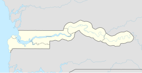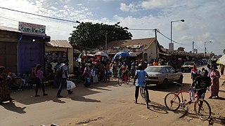
Brikama is one of the largest cities in the Gambia. It is also called 'Satey Ba' by the locals, meaning "big town". It lies southwest of the country's capital, Banjul. Brikama is the headquarters of the Brikama Local Government Area, and is the largest city in the region containing over twenty five wards with a population of over 100,000. As per the 2013 census, the population of Brikama LGA is 730,895.
Bamakuno Forest Park, or Bama Kuno, is a forest park in the Gambia. Established on January 1, 1954, it covers 1092 hectares. It is located 25 km to the south east of Brikama town in The Gambia.
Beri Kolon Forest Park, or Berikolon, is a forest park in the Gambia. Established on January 1, 1954, it covers 1052 hectares.
Brikama Forest Park is a forest park in the Gambia. Established on January 1, 1954, it covers 357 hectares.
Furnya Forest Park is a forest park in the Gambia. Established on January 1, 1954, it covers 405 hectares.
Jumba Yaka Forest Park is a forest park in Central River Division in the Gambia. Established on January 1, 1954, it covers 405 hectares.
Kabafita Forest Park is a forest park in the Gambia. Established on January 1, 1954, it covers 243 hectares.
Kahi Badi Forest Park is a forest park in the Gambia. Established on January 1, 1954, it covers 1485 hectares.
Kaiaf Forest Park is a forest park in the Gambia. Established on January 1, 1954, it covers 26 hectares.
Kunkilling Forest Park is a forest park in the Gambia. Established on January 1, 1954, it covers 142 hectares.
Kusum Forest Park is a forest park in the Gambia. Established on January 1, 1954, it covers 316 hectares.
Sabi Forest Park is a forest park in the Gambia. Established on January 1, 1954, it covers 73 hectares. It belongs to the Uper River Region (URR) and is about 5 kilometers from Basse Santa Su, which is the administrative seat of the region.
Marike Forest Park is a forest park, and is located in North Bank in the Gambia. Established on January 1, 1954, it covers 174 hectares.
Nianimaru Forest Park is a forest park in the Gambia. Established on January 1, 1954, it covers 607 hectares.
Jabisa Forest Park is a forest park in the Gambia. It covers 16 hectares.
Katilenge Forest Park is a forest park in the Gambia. It covers 324 hectares. The border with Senegal forms the southern border of the forest area.
Kenowore Forest Park is a forest park in the Gambia. It covers 67 hectares.
Sutukung Bani Forest Park is a Forest Park in the Gambia. It covers six hectares.
Kumadi Forest Park is a forest park in the Gambia. It covers 283 hectares.

Brikama Ba is a small town in the Fulladu East District, Central River Division, The Gambia. As of 2022, it has an estimated population of 10,343.