Robben Island is an island in Table Bay, 6.9 kilometres (4.3 mi) west of the coast of Bloubergstrand, north of Cape Town, South Africa. It takes its name from the Dutch word for seals (robben), hence the Dutch/Afrikaans name Robbeneiland, which translates to Seal(s) Island.

The Casbah is the citadel of Algiers in Algeria and the traditional quarter clustered around it. In 1992, the United Nations Educational, Scientific and Cultural Organization (UNESCO) proclaimed Kasbah of Algiers a World Cultural Heritage Site, as "There are the remains of the citadel, old mosques and Ottoman-style palaces as well as the remains of a traditional urban structure associated with a deep-rooted sense of community."

Kerkouane or Kerkuane is the site of an ancient Punic city in north-eastern Tunisia, near Cape Bon. Kerkouane was one of the most important Punic cities, with Carthage, Hadrumetum, and Utica. This Phoenician city was probably abandoned during the First Punic War and was not rebuilt by the Romans. It had existed for almost 400 years.
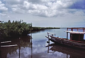
Diawling National Park lies in south-west Mauritania around the Senegal River delta. The park is an important wildlife sanctuary.
Climate Change 2007, the Fourth Assessment Report (AR4) of the United Nations Intergovernmental Panel on Climate Change (IPCC), was published in 2007 and is the fourth in a series of reports intended to assess scientific, technical and socio-economic information concerning climate change, its potential effects, and options for adaptation and mitigation. The report is the largest and most detailed summary of the climate change situation ever undertaken, produced by thousands of authors, editors, and reviewers from dozens of countries, citing over 6,000 peer-reviewed scientific studies. People from over 130 countries contributed to the IPCC Fourth Assessment Report, which took six years to produce. Contributors to AR4 included more than 2,500 scientific expert reviewers, more than 800 contributing authors, and more than 450 lead authors.

Bao BolongWetland Reserve is a protected area in The Gambia. Established in 1996, it covers 296.5 square kilometres.

The Fifth Assessment Report (AR5) of the United Nations Intergovernmental Panel on Climate Change (IPCC) is the fifth in a series of such reports and was completed in 2014. As had been the case in the past, the outline of the AR5 was developed through a scoping process which involved climate change experts from all relevant disciplines and users of IPCC reports, in particular representatives from governments. Governments and organizations involved in the Fourth Report were asked to submit comments and observations in writing with the submissions analysed by the panel. Projections in AR5 are based on "Representative Concentration Pathways" (RCPs). The RCPs are consistent with a wide range of possible changes in future anthropogenic greenhouse gas emissions. Projected changes in global mean surface temperature and sea level are given in the main RCP article.
Kalissaye Avifaunal Reserve (KAR) is a small nature reserve in Senegal, located at the mouth of Kalissaye Pond in the middle of the Casamance River.

Saloum Delta National Park or Parc National du Delta du Saloum in Senegal, is a 760-square-kilometre (190,000-acre) national park. Established in 1976, it is situated within the Saloum Delta at the juncture of the Saloum River and the North Atlantic.

The Island of Saint-Louis is the historic part of the city of Saint-Louis in Senegal. In 2000, it was inscribed by the UNESCO on the World Heritage list.
A climate change scenario is a hypothetical future based on a "set of key driving forces". Scenarios explore the long-term effectiveness of mitigation and adaptation. Scenarios help to understand what the future may hold. They can show which decisions will have the most meaningful effects on mitigation and adaptation.

The Medina of Tunis is the medina quarter of Tunis, the capital of Tunisia. It has been a UNESCO World Heritage Site since 1979.
The Cacheu River Mangroves Natural Park is a national park situated on the Cacheu River in Guinea-Bissau. It was established on 1 December 2000. This site is 886 km2. The park has been designated as a Ramsar site since 2015.
The Songhor Lagoon is a coastal lagoon on the eastern coast of Ghana, West Africa. The site covers an area of 28,740 hectares, and it is located just outside the major town of Ada and to the west of the Volta River estuary. It was designated as Ramsar wetland site of international importance number 566 on June 22, 1988. In 2011, UNESCO approved the Songor Biosphere Reserve as part of the World Network of Biosphere Reserves. Among several other important functions, it acts as habitat and/or breeding ground for several notable species.

Representative Concentration Pathways (RCP) are climate change scenarios to project future greenhouse gas concentrations. These pathways describe future greenhouse gas concentrations and have been formally adopted by the IPCC. The pathways describe different climate change scenarios, all of which were considered possible depending on the amount of greenhouse gases (GHG) emitted in the years to come. The four RCPs – originally RCP2.6, RCP4.5, RCP6, and RCP8.5 – are labelled after a possible range of radiative forcing values in the year 2100. The IPCC Fifth Assessment Report (AR5) began to use these four pathways for climate modeling and research in 2014. The higher values mean higher greenhouse gas emissions and therefore higher global surface temperatures and more pronounced effects of climate change. The lower RCP values, on the other hand, are more desirable for humans but would require more stringent climate change mitigation efforts to achieve them.
The Marromeu Game Reserve is a protected swath of 1,500 square kilometres (580 sq mi) of floodplain in the Zambezi, the only such area along the river. The reserve is characterized by vast grasslands and numerous rivers and streams. The African elephant, Lichtenstein's hartebeest, sable antelope, eland, burchell's zebra, hippopotamus, waterbuck, and reedbuck are all found there. Wild dogs, lions, leopards, cheetahs, and spotted hyenas are all predators. The Marromeu National Park is actively working to repopulate the area with buffalo after their population dwindled to 30,000. From the border of the buffalo reserve into the neighbouring Cheringoma highlands, a hunting concession of 8,252 square kilometres surrounds the Marromeu Complex, which consists of the 1,500-square-kilometer Marromeu Special Reserve. It was dedicated on 1 January 1969. It is located near Beira.

The Medina of Sousse is a Medina quarter in Sousse, Governorate of Sousse, Tunisia. Designated by the UNESCO a World Heritage Site in 1988, it is a typical example of the architecture of the early centuries of Islam in Maghreb. It encompasses a Kasbah, fortifications and the Great Mosque of Sousse. The Medina today houses the Archaeological Museum of Sousse. A number of Punic steles were discovered in the Medina, between the Ribat and the Great Mosque, in the 19th and 20th centuries.

Climate change in the Gambia is having impacts on the natural environment and people of The Gambia. Like other countries in West Africa, the impacts of climate change are expected to be varied and complex. Climate change adaptation is going to be important to achieve the Sustainable Development Goals in the country.
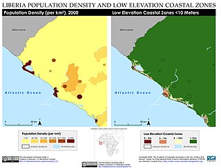
Climate change in Liberia causes many problems as Liberia is particularly vulnerable to climate change. Like many other countries in Africa, Liberia both faces existing environmental issues, as well as sustainable development challenges. Because of its location in Africa, it is vulnerable to extreme weather, the coastal effects of sea level rise, and changing water systems and water availability. Climate change is expected to severely impact the economy of Liberia, especially agriculture, fisheries, and forestry. Liberia has been an active participant in international and local policy changes related to climate change.
The Sixth Assessment Report (AR6) of the United Nations (UN) Intergovernmental Panel on Climate Change (IPCC) is the sixth in a series of reports which assess the available scientific information on climate change. Three Working Groups covered the following topics: The Physical Science Basis (WGI); Impacts, Adaptation and Vulnerability (WGII); Mitigation of Climate Change (WGIII). Of these, the first study was published in 2021, the second report February 2022, and the third in April 2022. The final synthesis report was finished in March 2023. It includes a summary for policymakers and was the basis for the 2023 United Nations Climate Change Conference (COP28) in Dubai.