Bao Bolong Wetland Reserve

Last updated
Bao Bolong Wetland Reserve
IUCN category VI (protected area with sustainable use of natural resources)
Gambia 110 from KG.jpg
Gambia adm location map.svg
Red pog.svg
LocationFlag of The Gambia.svg  Gambia, North Bank Division
Nearest city Salikenne
Coordinates 13°31′N15°52′W / 13.517°N 15.867°W / 13.517; -15.867
Area220 km²
Established1996
Official nameBaobolon Wetland Reserve
Designated16 September 1996
Reference no.860 [1]
1917260-near the Gambia River-The Gambia.jpg

Bao Bolong (also Baobolong, Bao Bolon or Baobolon) Wetland Reserve is a national park in The Gambia. Established in 1996 it covers 220 square kilometres.

Contents

The Wetland Reserve is located on the north bank of the River Gambia, approximately 100 km (52 nautical miles) from the river mouth. The name is derived from the Bao Bolon tributary that rises in Senegal and enters the River Gambia. [2] It extends from the River Gambia north to the Senegalese border along the Baobolon tributary.

History

On 1 January 1993, an area of 35 km2 was first declared as Bao Bolong National Reserve. From 16 September 1996 on, it has covered an extended area of 220 km2 (200 km2 according to other sources). It was the first reserve in the Gambia to be acknowledged as a wetland area worthy of protection according to the Ramsar Convention. Since 1975, this convention, whose draft had been initiated by the United Nations Educational, Scientific and Cultural Organization (UNESCO), protects the habitat of water birds and Charadriiformes. For other nature reserves in the country, such as Tanbi Wetland Complex or Niumi National Park (NNP), a Ramsar acknowledgement is also being aimed at by the Gambian authorities. As with NNP, it is intended to extend Bao Bolong Wetland Reserve across the border and to jointly administrate the area with Senegalese authorities.

Geography

The reserve features a length of 22 kilometres and an approximate width of nine km. The western part is located in the Central Baddibu district while the eastern part adheres to Upper Baddibu, both of which belonging to the North Bank Division.

Chiefly, the reserve is made up of the river Bao Bolong's estuary, one of the bigger tributaries of the river Gambia. It is located about 100 km away from the Gambia's mouth into Atlantic Ocean. The roughly 100 km long Bao Bolong river's spring is situated in Senegal. Furthermore, BBWR includes the rivers Salokini Bolong, Mandon Bolong, Duntu Malang Bolong, Tanku Bolong and Katchang Bolong.

The Gambia river thereby formes the southern boundary of the protected area. Approximately two kilometres away on the opposite bank of the river, the roughly 115 km2 large Kiang West National Park is located. A some two and a half kilometres wide zone of dense mangrove forest adjoines to the river. To the west lies the town of Salikenne (population about 4,000), which is also located near the Dobo Forest Park of 7.32 km2. At the western border, the Jalabiro Forest Park of 0.59 km2 can moreover be found.

The northern edge is bordered by the north bank road, Gambia's secondmost important highway. Along this road and the fork to Salikenne, several smaller towns like Nja Kunda, Minti Kunda, Kekuta Kunda, No Kunda, Konti Kunda Sukoto, Konti Kunda Nji and Illiassa are situated. In the east, following a fork of nine km length from the north bank road, the town of Katchang of 1,700 residents can be reached. Farafenni, with a population of more than 30,000 being the division's largest city, lies roughly 18 km outside the outer limits of BBWR to the east. Summed up, there are 25 small towns [3] which are situated at the wetland reserve's boundaries, one among them being inside the park limits proper. The inhabitants of these towns conduct fishery for personal requirements and their stock graze inside BBWR. Furthermore, they collect timber and fire wood there.

The terrain is flat, the highest elevation is cited with 12 metres above mean sea level.

Flora and fauna

Ecosystems

Sesuvium portulacastrum Sesuvium p.jpg
Sesuvium portulacastrum
Nere (Parkia biglobosa) Parkia biglobosa Burkina.jpg
Néré (Parkia biglobosa)

Bao Bolong Wetland Reserve includes a rich fauna and flora within multiple ecosystems. Important, protected tree species are pointed out by the "Ramsar Information Sheet", [4] such as Pterocarpus erinaceus , Parinari macrophylla , the ana tree, wild mango trees ( Cordyla africana ) and Néré ( Parkia biglobosa ).

Mangroves

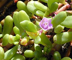
Only in the mangrove forest of Bao Bolong Wetland Reserve the mangrove trees of the Senegambia region reach a height of 20 metres. The species Rhizophora racemosa , red mangrove (Rhizophora mangle) and black mangrove (Avicennia germinans) are widespread among them.

Salt marshes

In the salt marshes, e.g. the succulent Sesuvium portulacastrum and grasses like Sporobolus spicatus , Paspalum vaginatum as well as Diplachne fusca can be found. In the savanna, which at times is flooded, Phragmites karka , Echinochloa pyramidalis and paper reed are very common.

Savannah

In the savannah, trees like Daniellia oliveri , Terminalia albida , Bombax costatum and others are to be found. Among the shrubs one will encounter several species of figs, Physostigma thonningii , Terminalia avicennoides , Anthostema senegalense and Nauclea latifolia . As of grasses, Andropogon tectorum and Gamba grass ( Andropogon gayanus ), Beckeropsis uniseta and Pennisetum subangustum are common.

Avifauna

Grey heron (Ardea cinerea) Fischreiher.jpg
Grey heron (Ardea cinerea)
Common sandpiper (Actitis hypoleucos) Actitis hypoleucos 1 tb (Marek Szczepanek).jpg
Common sandpiper (Actitis hypoleucos)
Night heron (Nycticorax n. nycticorax) Nycticorax-nycticorax-004.jpg
Night heron (Nycticorax n. nycticorax)
Little egret (Egretta garzetta) Egretta garzetta 1.jpg
Little egret (Egretta garzetta)
Woodland kingfisher (Halcyon senegalensis) WoodlandKingfisher.jpg
Woodland kingfisher (Halcyon senegalensis)

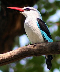
The Gambia is frequently visited by ornithologists as more than 540 species of birds have been described there in topic literature. Bao Bolong Wetland Reserve is one of the major targets for tourists and scientists who intend to explore the Gambia's manifold avifauna. Among the birds of BBWR, which include 268 species of 62 families, [3] the Ramsar Information Sheet exemplarily lists the following:

Typical for a wetland, BBWR is the habitat of many water birds, which also include geese. Among them comb duck (Sarkidiornis melanotos), spur-winged goose (Plectropterus gambensis), white-faced whistling duck (Dendrocygna viduata), garganey (Anas querquedula), northern pintail (Anas acuta), African pygmy goose (Nettapus auritus) and the northern shoveler (Anas clypeata).

The Aequornithes are represented by birds like western reef heron (Egretta gularis), little egret (Egretta garzetta), woolly-necked stork (Ciconia episcopus), hammerkop (Scopus umbretta), squacco heron (Ardeola ralloides), little bittern (Ixobrychus minutus), Goliath heron (Ardea goliath), great egret (Ardea alba), marabou (Leptoptilos crumeniferus), night heron (Nycticorax nycticorax), grey heron (Ardea cinerea), cattle egret (Bubulcus ibis) and the sacred ibis (Threskiornis aethiopicus). With their long legs, many of these birds search the river banks for food. Of this group, the pink-backed pelican (Pelecanus rufescens) and African darter (Anhinga rufa) also live within the BBWR.

The brackish water areas feature Charadriidae. Spur-winged lapwing (Hoplopterus spinosus), little stint (Calidris minuta) and common sandpiper (Actitis hypoleucos) can be found.

Among the colourful family of kingfishers, which preferably occur near open water, the woodland kingfisher, pied kingfisher (Ceryle rudis), swallow-tailed bee-eater (Merops hirundineus), giant kingfisher (Ceryle maxima), malachite kingfisher (Alcedo cristata) and the blue-breasted kingfisher (Halcyon malimbica) are notable.

Equally colourful are the west African examples of starlings. Among them, the violet-backed starling (Cinnyricinclus leucogaster) and the long-tailed glossy-starling (Lamprotornis caudatus) can be found inside the Bao Bolong Wetland Reserve.

The Coraciiformes include the Abyssinian ground-hornbill (Bucorvus abyssinicus) and the European roller (Coracias garrulus).

Also species of parrots can be found in west Africa, among them are the Senegal parrot (Poicephalus senegalus) and the rose-ringed parakeet (Psittacula krameri).

The birds of prey include species like African fish eagle (Haliaeetus vocifer), red-necked buzzard (Buteo auguralis) and black kite (Milvus migrans) as well as the bateleur (Terathopius ecaudatus).

Moreover, African mourning doves (Streptopelia decipiens) of the genus Streptopelia and the little swift (Apus affinis) from the swift family have been spotted.

Fish and other water animals

Among BBWR's ichthyofauna, some fish are noted in the "Ramsar Information Sheet": Ethmalosa fimbriata , barracudas (Sphyraena sp.), Polydactylus quadrifilis , Arius latiscutatus , Pseudotolithus elongatus , Pomadasys perotaei and Pseudotolithus bracygnathus . Also tilapia (Tilapia) and mullets (Mugilidae) occur in these waters. Furthermore, a type of oyster, Crassostrea gasar and blue crab ( Callinectes sapidus ) can be found.[ citation needed ]

The West African manatee (Trichechus senegalensis), a mammal, lives in the water between the mangroves and is categorized as an endangered species.

Moreover, the West African Crocodile (Crocodylus suchus) is a common species of reptile.

Mammals

Thirty-two species of mammals are known, the "Ramsar Information Sheet" lists the African clawless otter (Aonyx capensis), which is common to the area. Several species of antelopes like sitatunga (Tragelaphus spekeii), bushbuck (Tragelaphus scriptus) and the duiker (Cephalophinae) as well as warthogs (Phacochoerus africanus).

Among the predators, the spotted hyena (Crocuta crocuta) is common. Also leopards (Panthera pardus) are attributed to the BBWR.

The primates, according to the "Ramsar Information Sheet", include the red colobus (Piliocolobus), the patas monkey (Erythrocebus patas) and green monkeys (Chlorocebus). But also the Guinea baboon (Papio papio) and the Senegal bushbaby (Galago senegalensis) can be found.

Tourism

The area is only moderately used for tourism. Ecotourism, including bird watching and common observations of nature, shall be further developed though. Next to this, boat tours through the mangroves are conducted.

Climate change

In 2022, the IPCC Sixth Assessment Report included Bao Bolong Wetland Reserve in the list of African natural heritage sites which would be threatened by flooding and coastal erosion by the end of the century, but only if climate change followed RCP 8.5, which is the scenario of high and continually increasing greenhouse gas emissions associated with the warming of over 4 °C., [5] and is no longer considered very likely. [6] [7] The other, more plausible scenarios result in lower warming levels and consequently lower sea level rise: yet, sea levels would continue to increase for about 10,000 years under all of them. [8] Even if the warming is limited to 1.5 °C, global sea level rise is still expected to exceed 2–3 m (7–10 ft) after 2000 years (and higher warming levels will see larger increases by then), consequently exceeding 2100 levels of sea level rise under RCP 8.5 (~0.75 m (2 ft) with a range of 0.5–1 m (2–3 ft)) well before the year 4000. [9]

Related Research Articles

<span class="mw-page-title-main">Geography of the Gambia</span>

The Gambia is a very small and narrow African country with the border based on the Gambia River. The country is less than 48 kilometres (30 mi) wide at its greatest width. The country's present boundaries were defined in 1889 after an agreement between the United Kingdom and France. It is often claimed by Gambians that the distance of the borders from the Gambia River corresponds to the area that British naval cannon of the time could reach from the river's channel. However, there is no historical evidence to support the story, and the border was actually delineated using careful surveying methods by the Franco-British boundary commission. The Gambia is almost an enclave of Senegal and is the smallest country on mainland Africa.

<span class="mw-page-title-main">Macquarie Marshes</span> Wetland in Australia

The Macquarie Marshes comprise the wetlands associated with the floodplains of the Macquarie River and its tributaries, in northern New South Wales, Australia. The Macquarie River and the marshes eventually drain into the Darling River. The marshes are important as a breeding site for waterbirds, especially in the aftermath of major floods.

The Diawling National Park lies in south west Mauritania around the Senegal River delta. During the rainy season, much of the park consists of large lakes. It is known for having over 220 species of identified birds, including pelicans, black storks, and flamingos, and also for its fish.

<span class="mw-page-title-main">Sultanpur National Park</span> National Park in Haryana, India

Sultanpur National Park (formerly Sultanpur Bird Sanctuary) is located at Sultanpur village on Gurugram-Jhajjar highway, 15 km from Gurugram, Haryana and 50 km from Delhi in India. This covers approximately 142.52 hectares.

<span class="mw-page-title-main">Wildlife of the Gambia</span>

Wildlife of the Gambia is dictated by several habitat zones over its total land area of about 10,000 km2. It is bound in the south by the savanna and on the north by the Sudanian woodlands. The habitats host abundant indigenous plants and animals, in addition to migrant species and newly planted species. They vary widely and consist of the marine system, coastal zone, estuary with mangrove vegetation coupled with Banto Faros, river banks with brackish and fresh water zones, swamps covered with forests and many wetlands.

<span class="mw-page-title-main">Menabe Antimena</span> Protected area in Menabe, Madagascar

Menabe Antimena is a protected area in Menabe region of western Madagascar. It belongs to the municipalities of Tsimafana, Beroboka, Bemanonga, Belon'i Tsiribihina, and Tsaraotana.

<span class="mw-page-title-main">Kuala Selangor Nature Park</span>

The Kuala Selangor Nature Park is a park located by the mouth of Selangor River in Kuala Selangor District, Selangor, Malaysia. It was established by the Selangor state government in 1987 and has been managed by the Malaysian Nature Society who have proposed that it be declared a wetland of international importance.

<span class="mw-page-title-main">Kota Kinabalu Wetland Centre</span>

Kota Kinabalu Wetland Centre is 24 hectares of the only remains of mangrove forest that once existed extensively along the coastal region of Kota Kinabalu, Malaysia. Previously known as Likas Swamp or Likas Mangrove and later Kota Kinabalu City Bird Sanctuary, the Centre came foremost out of 20 wetlands selected by the Sabah Wetlands Inventory Committee in 1986.

Assagny National Park or Azagny National Park is a national park in the south of Ivory Coast. It is situated on the coast some 75 km (47 mi) to the west of Abidjan, between the mouth of the Bandama River and the Ébrié Lagoon, and occupies an area of about 17,000 hectares.

Niumi National Park is a national park in The Gambia. The occupies the coastal strip in the northern region of the country, in the southern tip of the Sine-Saloum Delta. It covers an area of approximately 4,940 ha and encompasses a range of types of wetlands and vegetation, from freshwater marsh to sand spits and brackish lagoons. Rhizophora mangrove forest is abundant in the park, and its swamp and mudflats are an important sheltering ground for birds, with over 200 species found here.

<span class="mw-page-title-main">Tanbi Wetland Complex</span>

Tanbi Wetland Complex is a wetland reserve in the Gambia outside of Banjul which was established in 2001.

Kalissaye Avifaunal Reserve (KAR) is a small nature reserve in Senegal, located at the mouth of Kalissaye Pond in the middle of the Casamance River.

<span class="mw-page-title-main">Saloum Delta National Park</span> UNESCO World Heritage Site in Senegal

Saloum Delta National Park or Parc National du Delta du Saloum in Senegal, is a 760-square-kilometre (190,000-acre) national park. Established in 1976, it is situated within the Saloum Delta at the juncture of the Saloum River and the North Atlantic.

<span class="mw-page-title-main">Rietvlei Wetland Reserve</span> Nature reserve in Table View, Western Cape, South Africa.

The Rietvlei Wetland Reserve is a 663-hectare (1,640-acre) nature reserve situated in Table View, Western Cape, South Africa. It is managed by the City of Cape Town's Environmental Resource Management Department.

The Diep River Fynbos Corridor is a nature reserve located in the Blaauwberg region of Cape Town, South Africa. It forms part of the larger Table Bay Nature Reserve, which was established in June 2012.

The Songor Lagoon is located at 05°45'N 000°30'E on the eastern coast of Ghana, West Africa. The site covers an area of 28,740 hectares, and it is located just outside the major town of Ada and to the west of the Volta River estuary. It was designated as Ramsar wetland site of international importance number 566 on June 22, 1988. In 2011, UNESCO approved the Songor Biosphere Reserve as part of the World Network of Biosphere Reserves. Among several other important functions, it acts as habitat and/or breeding ground for several notable species.

Hungry Bay Nature Reserve is a nature reserve on the east coast of Bermuda. It was established in 1986. It is considered the best example of coastal mangrove swamp on the island. It includes the Hungry Bay area and the largest mangrove coastal swamp in Bermuda. It is protected by a Tree preservation order (T.P.O.) and designated as an official Nature Reserve within the Parks system of Bermuda.

<span class="mw-page-title-main">Ría Lagartos Biosphere Reserve</span>

Ría Lagartos Biosphere Reserve is a UNESCO Biosphere Reserve in the state of Yucatán, Mexico. The reserve is located at the eastern end of the coastal strip of the Yucatán Peninsula, with the Gulf of Mexico at its northern limit. The area encompasses coastal areas of the Gulf of Mexico and includes important wetlands designated under the Ramsar Wetlands Convention. The site presents a rich diversity of landscapes and ecosystems, such as mangroves, small estuaries, medium semi-evergreen forest, low deciduous forest, coastal dune vegetation, coastal lagoons, marshes (petenes) and savanna represented by tular vegetation, grasslands and reed beds that are the main nesting sites for marshland and sea birds.

<span class="mw-page-title-main">Alvarado mangroves</span> Mangroves ecoregion of Tamaulipas and Veracruz, Mexico

The Alvarado mangroves ecoregion covers a series of mangrove forest areas along the Gulf of Mexico coast of the states of Tamaulipas and Veracruz in Mexico. they are the most northerly mangroves in the western Gulf. The largest tracts of mangrove swamps occur at the mouths of rivers, and nearby coastal lagoon.

References

  1. "Baobolon Wetland Reserve". Ramsar Sites Information Service. Retrieved 25 April 2018.
  2. "Bao Bolo Wetland Reserve". Programme Regional de Conservation. 2005. Retrieved 31 July 2008.
  3. 1 2 Bao Bolong Wetland Reserve www.prcmarine.org
  4. Ramsar Information Sheet [ permanent dead link ]
  5. Trisos, C.H., I.O. Adelekan, E. Totin, A. Ayanlade, J. Efitre, A. Gemeda, K. Kalaba, C. Lennard, C. Masao, Y. Mgaya, G. Ngaruiya, D. Olago, N.P. Simpson, and S. Zakieldeen 2022: Chapter 9: Africa. In Climate Change 2022: Impacts, Adaptation and Vulnerability [H.-O. Pörtner, D.C. Roberts, M. Tignor, E.S. Poloczanska, K. Mintenbeck, A. Alegría, M. Craig, S. Langsdorf, S. Löschke,V. Möller, A. Okem, B. Rama (eds.)]. Cambridge University Press, Cambridge, United Kingdom and New York, NY, USA, pp. 2043–2121
  6. Hausfather, Zeke; Peters, Glen (29 January 2020). "Emissions – the 'business as usual' story is misleading". Nature. 577 (7792): 618–20. Bibcode:2020Natur.577..618H. doi: 10.1038/d41586-020-00177-3 . PMID   31996825.
  7. Hausfather, Zeke; Peters, Glen (20 October 2020). "RCP8.5 is a problematic scenario for near-term emissions". PNAS. 117 (45): 27791–27792. doi: 10.1073/pnas.2017124117 .
  8. Technical Summary. In: Climate Change 2021: The Physical Science Basis. Contribution of Working Group I to the Sixth Assessment Report of the Intergovernmental Panel on Climate Change (PDF). IPCC. August 2021. p. TS14. Retrieved 12 November 2021.
  9. IPCC, 2021: Summary for Policymakers. In: Climate Change 2021: The Physical Science Basis. Contribution of Working Group I to the Sixth Assessment Report of the Intergovernmental Panel on Climate Change [Masson-Delmotte, V., P. Zhai, A. Pirani, S.L. Connors, C. Péan, S. Berger, N. Caud, Y. Chen, L. Goldfarb, M.I. Gomis, M. Huang, K. Leitzell, E. Lonnoy, J.B.R. Matthews, T.K. Maycock, T. Waterfield, O. Yelekçi, R. Yu, and B. Zhou (eds.)]. Cambridge University Press, Cambridge, United Kingdom and New York, NY, USA, pp. 3−32, doi:10.1017/9781009157896.001.

Further reading