In Australia, bushland is a blanket term for land which supports remnant vegetation or land which is disturbed but still retains a predominance of the original floristics and structure.

The City of Logan is a local government area situated within the south of the Brisbane metropolitan area in South East Queensland, Australia. Situated between the City of Brisbane to the north and the City of Gold Coast to the south, the City also borders the Scenic Rim Region, the City of Ipswich, and Redland City LGAs. Logan City is divided into 70 suburbs and 12 divisions; a councillor is elected to each of the latter. The council had a population of 326,615 in June 2018.

Bald Hills is the northernmost suburb in the City of Brisbane, Queensland, Australia. In the 2021 census, Bald Hills had a population of 7,000 people.

Bulimba Creek, originally known as Doboy Creek or Doughboy Creek, is a perennial stream that is a tributary of the Brisbane River, located in suburban Brisbane in the South East region of Queensland, Australia.

Stretton is a southern suburb in the City of Brisbane, Queensland, Australia. In the 2016 census, Stretton had a population of 4,334. The suburb is known for its Hollywood-sized mansions on nearby streets off Gowan and Compton Roads.

Mullum Mullum Creek is a creek in the outer eastern suburbs of Melbourne, Victoria, Australia. It is the main watercourse of the Mullum Mullum Valley, a tributary of the Yarra River and Yarra Valley. For tens of thousands of years it was used as a food and tool source sustainably by the Wurundjeri people, Indigenous Australians of the Kulin nation, who spoke variations of the Woiwurrung language group.

Burbank is a greenbelt suburb in the City of Brisbane, Queensland, Australia. In the 2016 census, Burbank had a population of 1,050 people.
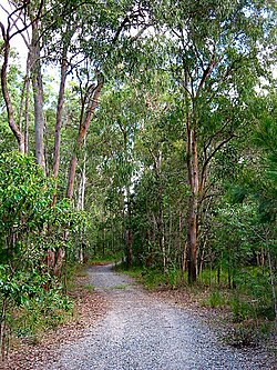
The Manly Dam Reserve, also known as the Manly Warringah War Memorial Park, is an urban bushland reserve located in the Northern Beaches region of Sydney, Australia. The reserve adjoins the south-eastern edge of Garigal National Park.

Larapinta is an outer southern industrial suburb in the City of Brisbane, Queensland, Australia. In the 2016 census, Larapinta had a population of 0 people.

Boronia Heights is a suburb in the City of Logan, Queensland, Australia. In the 2016 census, Boronia Heights had a population of 7,862 people.

Karawatha is an outer southern suburb in the City of Brisbane, Queensland, Australia. In the 2016 census, Karawatha had a population of 19 people.
The Bidjigal Reserve is a 186-hectare (460-acre) reserve in New South Wales, Australia. It lies predominantly within The Hills Shire, with a small section south of the M2 Motorway in the City of Parramatta. The reserve lies in the suburbs of North Rocks, Northmead, Baulkham Hills, Castle Hill, West Pennant Hills, and Carlingford. The reserve lies south of Richard Webb Reserve in West Pennant Hills, with the majority located to the north of the M2 Motorway.

Sheldon is a rural residential locality in the City of Redland, Queensland, Australia. In the 2016 census, Sheldon had a population of 1,704 people.

Moggill Creek is a creek in Brisbane, the largest city in Queensland, Australia. The creek rises on the Taylor Range and runs in a south-easterly direction from the southern edge of Brisbane Forest Park in Kholo and Pullenvale, flowing through Upper Brookfield, Brookfield and joining the Brisbane River at Kenmore. Before entering the Brisbane River the creek is crossed by Moggill Road and winds through Rafting Ground Reserve.
Burpengary Creek is a tidal creek in the City of Moreton Bay, Queensland, Australia. It has a total catchment area of 7,960 hectares. It is about 40 kilometres north of Brisbane,

Logan Village is a semi-rural town and locality in the City of Logan, Queensland, Australia. In the 2016 census, the locality of Logan Village had a population of 4,417 people. Logan Village was once known as the head of the navigable Logan River. Its importance as a town grew again when the railway arrived.

Yarran Dheran Nature Reserve forms part of the Mullum Mullum Valley and is an important riparian bushland park, located in the outer eastern suburbs of Melbourne on the border of Donvale, on the banks of the Mullum Mullum Creek. The Reserve comprises 7.2 hectares and hosts a mix of remnant and regenerated bushland, and many native species of wildlife, particularly birds, of which some 85 species may be seen over time. The Mullum Mullum Creek Trail runs through the Reserve and there are many unsealed bush tracks through the native bushland. There is an Information Centre in the Reserve which is open on Sunday afternoons from 2.00 pm – 4.00 pm subject to volunteer availability. The Reserve includes a series of ponds that feed a cascade to the creek during wet spells. There are toilets and mown areas for picnics and seating. Yarran Dheran is a Dogs on Lead Reserve.

The Wolli Creek Regional Park is a 50 hectares regional park, located adjacent to Wolli Creek within the Wolli Creek Valley, between Bexley North and Tempe in south-west Sydney, New South Wales, Australia.

The Central Gardens Nature Reserve, also called Central Gardens, is a protected nature reserve located in the western suburbs of Sydney, New South Wales, Australia. Established in 1976, the 12-hectare (30-acre) reserve, garden and fauna and wildlife park is situated in the suburb of Merrylands and is managed by Cumberland Council. The park is regionally important and it attracts visitors outside the Cumberland local government area. The bushland contains remnants of Cumberland Plain Woodland and is approximately 3.5 hectares.

Limeburners Creek National Park is a protected national park on the Mid North Coast of New South Wales, Australia. The 91.2 km national park is located 5 km (3.1 mi) to the north of Port Macquarie and exists across both the Kempsey Shire and Port Macquarie-Hastings Council local government areas, but is chiefly managed by National Parks and Wildlife Service. The area was originally erected as a nature reserve but this reservation was revoked when it became formally recognised as a national park in 2010 under the National Parks and Wildlife Act (1974). Many threatened ecological habitats and species of fauna and flora are found within this park, alongside several heritage sites of cultural significance, particularly to the local Birpai and Dunghutti people upon whose land the park exists. The protected status of this national park is largely owing to the ecological and cultural value of the area, in addition to the value of the ecosystems to further scientific research.