
Ruse Province is a province in northern Bulgaria, named after its main city - Ruse, neighbouring Romania via the Danube. It is divided into 8 municipalities with a total population, as of February 2011, of 235,252 inhabitants.

Dobrich Province is a province in northeastern Bulgaria, part of Southern Dobruja geographical region. It is bounded on east by the Black Sea, on south by Varna Province, on west by Yambol & Sliven provinces, on north by Shumen & Varna provinces. It is divided into 8 municipalities. At the 2011 census, it had a population of 186,016.
Vama Veche is a village in Constanţa County, Romania, on the Black Sea coast, near the border with Bulgaria, at 28.57 E longitude, 43.75 N latitude. It is part of the commune of Limanu and in 2002, it had a population of 178.

Negru Vodă is a town in Constanța County, Dobruja, south-eastern Romania. The town is close to the border with Bulgaria and there is a border crossing linking Negru Vodă to the Bulgarian village Kardam.

Nikopol is a town in northern Bulgaria, the administrative center of Nikopol municipality, part of Pleven Province, on the right bank of the Danube river, 4 kilometres downstream from the mouth of the Osam river. It spreads at the foot of steep chalk cliffs along the Danube and up a narrow valley. As of December 2009, the town has a population of 3,892 inhabitants.

Opaka is a town in Targovishte Province in northeast Bulgaria. As of December 2009, the town had a population of 2,873 and covers an area of 57 square kilometres (22 sq mi). It is 70 kilometres (43 mi) south of the city of Rousse on the border with Romania and 250 kilometres (160 mi) northeast of the Bulgarian capital, Sofia. Archeologists have found evidence of Thracian, Roman and Slavonic settlements in the area. Near the village of Krepcha, a stone monastery is the site of the oldest known Old Bulgarian Cyrillic inscription, dated from around 920 CE. A 2nd century Thracian tumulus containing various artifacts, including six leaves of a golden wreath and bronze figurines, was excavated in 2011.
The Ludogorie or Deliorman, all meaning "region of mad forests", is a region in northeastern Bulgaria stretching over the plateau of the same name. Major cities in the region are Razgrad, Novi Pazar, Pliska and Isperih. Part of the Danubian Plain, the region is hilly in the east, reaching up to 485.70 metres (1,593.5 ft) in height near the village of Samuil, but merges with the plains of Dobruja and the Danube to the north, with the lowest point near Yuper. The region is bordered to the west by the Provadiya River and the Beli Lom; to the east it transitions into the Dobruja plateau.

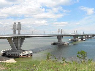
The Danube Bridge is a steel truss bridge over the Danube River connecting the Bulgarian bank to the south with the Romanian bank to the north and the cities of Ruse and Giurgiu respectively. It is one of only two bridges connecting Romania and Bulgaria, the other one being the New Europe Bridge between the cities of Vidin and Calafat. The Danube bridge can be reached by using public transport - bus lines 4,11,12 and 28.
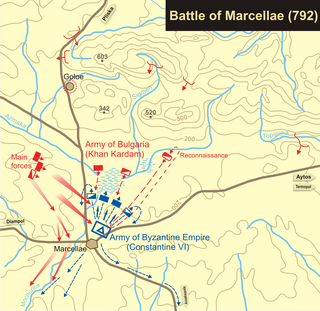
The Battle of Marcellae took place in 792 at Marcellae (Markeli), near the modern town of Karnobat in south eastern Bulgaria, the same site as an earlier battle in 756. The battle was between the forces of the Byzantine Empire, led by Constantine VI, and those of Bulgaria under Kardam. The Byzantines were routed and forced to retreat to Constantinople.

Krushari is a village in northeastern Bulgaria, part of Dobrich Province. It is the administrative centre of Krushari Municipality, which lies in the northwestern part of the province. Krushari is located 32 kilometres from the provincial capital of Dobrich, 85 kilometres from Varna and around 70 kilometres from Balchik and Silistra.
Tervel is a town in northeastern Bulgaria, part of Dobrich Province. It is the administrative centre of Tervel Municipality, which lies in the westernmost part of the province. As of December 2009, the town has a population of 6,667 inhabitants.
Kaynardzha is a village in northeastern Bulgaria, part of Silistra Province. It is the administrative centre of Kaynardzha Municipality, which lies in the easternmost part of Silistra Province, in the historical region of Southern Dobruja, close to the Romanian border.
Dimovo is a town in northwestern Bulgaria, part of Vidin Province. It is the administrative centre of the homonymous Dimovo Municipality, which lies in the eastern part of Vidin Province, 30 kilometres from Vidin at the Danube and 50 kilometres from Bregovo at the Timok River and the Serbian border. As of December 2009, Dimovo has a population of 1,211 inhabitants.

The 19th Multi-member Constituency – Ruse is a constituency whose borders are the same as Ruse Province in Bulgaria.
Gurkovo is a village in Balchik Municipality, Dobrich Province, northeastern Bulgaria. Between 1913 and 1940, during the Romanian rule, the village was called Rasoviceni.
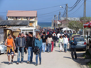
Vaklino is a village in Shabla Municipality, Dobrich Province, northeastern Bulgaria. The village is located few minutes from the border with Romania. While the village of Vaklino is very quiet and uneventful, it is just across the border from Vama Veche, a Romanian town very popular among backpackers. From visitor's point of view, Vaklino has only an abandoned remnant of central square and no stores or services of any kind. Apart from its people and their certainly unique life-stories, it offers only the picturesqueness of an utterly insignificant Eastern European village. Most people in this Village are either its residents or passer bys on the road from Romania to more southern parts of Bulgaria.

Kardam was the ruler of Bulgaria.

European route E 675 is a European B class road in Romania and Bulgaria, connecting the cities Agigea – Kardam.
The Bulgaria–Romania border is the state border between Bulgaria and Romania.


