Petleshkovo | |
---|---|
Village | |
Country | |
Province | Dobrich Province |
Municipality | General Toshevo Municipality |
Time zone | UTC+2 (EET) |
• Summer (DST) | UTC+3 (EEST) |
Petleshkovo is a village in General Toshevo Municipality, Dobrich Province, in northeastern Bulgaria. [1]
General Toshevo Municipality is a municipality (obshtina) in Dobrich Province, Northeastern Bulgaria, located in Southern Dobruja geographical region, bounded by Romania to the north. It is named after its administrative centre - the town of General Toshevo.
Dobrich Province is a province in northeastern Bulgaria, part of Southern Dobruja geographical region. It is bounded on east by the Black Sea, on south by Varna Province, on west by Yambol & Sliven provinces, on north by Shumen & Varna provinces. It is divided into 8 municipalities. At the 2011 census, it had a population of 186,016.
Bulgaria, officially the Republic of Bulgaria, is a country in Southeast Europe. It is bordered by Romania to the north, Serbia and North Macedonia to the west, Greece and Turkey to the south, and the Black Sea to the east. The capital and largest city is Sofia; other major cities are Plovdiv, Varna and Burgas. With a territory of 110,994 square kilometres (42,855 sq mi), Bulgaria is Europe's 16th-largest country.
Petleshkov Hill in Antarctica is named after the village. [2]
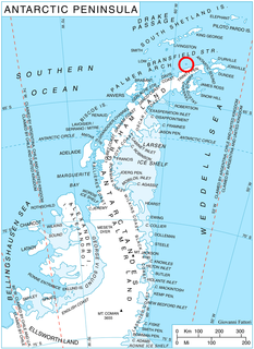
Petleshkov Hill is the ice-covered hill rising to 221 m in northwestern Astrolabe Island in Bransfield Strait, Antarctica. It surmounts Mokren Bight to the south.
Antarctica is Earth's southernmost continent. It contains the geographic South Pole and is situated in the Antarctic region of the Southern Hemisphere, almost entirely south of the Antarctic Circle, and is surrounded by the Southern Ocean. At 14,200,000 square kilometres, it is the fifth-largest continent. For comparison, Antarctica is nearly twice the size of Australia. About 98% of Antarctica is covered by ice that averages 1.9 km in thickness, which extends to all but the northernmost reaches of the Antarctic Peninsula.
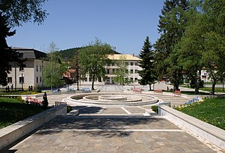
Godech is a small town located in the Sofia Province, of Bulgaria. The town is founded in a valley on the far west of Stara Planina, where the Nishava River passes. The settlement is about 20 km east of the Serbian border and has its highest peak Kom to the north. Godech is officially a town with 4,663 inhabitants. It is the administrative center of the Godech municipality.
Obidim is a village (село) in southwestern Bulgaria, located in the Bansko Municipality of the Blagoevgrad Province in Pirin mountain 15 kilometers southeast of Bansko and 52 km southeast of Blagoevgrad.
Smyadovo is a town in eastern Bulgaria, part of Shumen Province. It is the administrative centre of the homonymous Smyadovo Municipality, which lies in the southeastern part of the province. As of December 2009, the town has a population of 4,036 inhabitants.
Polski Trambesh is a town in central northern Bulgaria, part of Veliko Tarnovo Province. It is the administrative centre of the homonymous Polski Trambesh Municipality, which lies in the northeastern part of the Province. The town is located 36 kilometres from the provincial capital of Veliko Tarnovo, 45 km from Svishtov, 35 km from Pavlikeni, 33 km from Gorna Oryahovitsa, 22 km from Byala, Rousse Province and 40 km from Strazhitsa. As of December 2009, Polski Trambesh has a population of 4,546 inhabitants.
Mokren Bight is a 2 km wide embayment indenting for 850 m the west coast of Astrolabe Island in Bransfield Strait off Trinity Peninsula, Antarctica. Entered northwest of Gega Point and southeast of the small peninsula featuring Petleshkov Hill, projecting westwards and ending in Damga Point to the south and Raduil Point to the north.
Karvuna is a village in Balchik Municipality, Dobrich Province, northeastern Bulgaria.
Senokos is a village in Balchik Municipality, Dobrich Province, northeastern Bulgaria.
Travnik is a village in Kavarna Municipality, Dobrich Province, northeastern Bulgaria.
Topola is a village in Kavarna Municipality, Dobrich Province, northeastern Bulgaria.
Gorichane is a village in Shabla Municipality, Dobrich Province, northeastern Bulgaria.
Smin is a village in Shabla Municipality, Dobrich Province, northeastern Bulgaria.
Balvantsite is a village in Dryanovo Municipality, in Gabrovo Province, in northern central Bulgaria.
Dlugnya is a village in Dryanovo Municipality, in Gabrovo Province, in northern central Bulgaria.
Gozdeyka is a village in Dryanovo Municipality, in Gabrovo Province, in northern central Bulgaria.
Katrandzhii is a village in Dryanovo Municipality, in Gabrovo Province, in northern central Bulgaria.
Kosarka is a village in Dryanovo Municipality, in Gabrovo Province, in northern central Bulgaria.
Manoya is a village in Dryanovo Municipality, in Gabrovo Province, in northern central Bulgaria.
Plachka is a village in Dryanovo Municipality, in Gabrovo Province, in northern central Bulgaria.
Turkincha is a village in Dryanovo Municipality, in Gabrovo Province, in northern central Bulgaria.
Rogachevo is a village in Balchik Municipality, Dobrich Province, northeastern Bulgaria.
Coordinates: 43°39′N28°01′E / 43.650°N 28.017°E
A geographic coordinate system is a coordinate system that enables every location on Earth to be specified by a set of numbers, letters or symbols. The coordinates are often chosen such that one of the numbers represents a vertical position and two or three of the numbers represent a horizontal position; alternatively, a geographic position may be expressed in a combined three-dimensional Cartesian vector. A common choice of coordinates is latitude, longitude and elevation. To specify a location on a plane requires a map projection.
This Dobrich Province, Bulgaria location article is a stub. You can help Wikipedia by expanding it. |