Sirakovo, Dobrich Province

Last updated
Sirakovo
Village
Bulgaria location map.svg
Red pog.svg
Sirakovo
Location in Bulgaria
Coordinates: 43°39′07″N28°16′05″E / 43.652°N 28.268°E / 43.652; 28.268 Coordinates: 43°39′07″N28°16′05″E / 43.652°N 28.268°E / 43.652; 28.268
CountryFlag of Bulgaria.svg  Bulgaria
Province Dobrich Province
Municipality General Toshevo Municipality
Area
  Total 21,165 km2 (8,172 sq mi)
Elevation 100 m (300 ft)
Population (2010)
  Total 92
Time zone EET (UTC+2)
  Summer (DST) EEST (UTC+3)

Sirakovo is a village in General Toshevo Municipality, Dobrich Province, in northeastern Bulgaria. [1]

General Toshevo Municipality Municipality in Dobrich, Bulgaria

General Toshevo Municipality is a municipality (obshtina) in Dobrich Province, Northeastern Bulgaria, located in Southern Dobruja geographical region, bounded by Romania to the north. It is named after its administrative centre - the town of General Toshevo.

Dobrich Province Province in Bulgaria

Dobrich Province is a province in northeastern Bulgaria, part of Southern Dobruja geographical region. It is bounded on east by the Black Sea, on south by Varna Province, on west by Yambol & Sliven provinces, on north by Shumen & Varna provinces. It is divided into 8 municipalities. At the 2011 census, it had a population of 186,016.

Bulgaria country in Southeast Europe

Bulgaria, officially the Republic of Bulgaria, is a country in Southeast Europe. It is bordered by Romania to the north, Serbia and North Macedonia to the west, Greece and Turkey to the south, and the Black Sea to the east. The capital and largest city is Sofia; other major cities are Plovdiv, Varna and Burgas. With a territory of 110,994 square kilometres (42,855 sq mi), Bulgaria is Europe's 16th-largest country.

Contents

Characteristics

The only office building is located in the village center. Here are housed the town hall and general store. Earlier there was a pub, called "Horemag", bakery and barber shop are closed a long time ago. Sirakovo residents are about a hundred. About 50 houses are in Sirakovo, 10 of them are inhabited. As in neighboring villages Velikovo and Sarnino where purchased English estate, foreigners started to show interest in Sirakovo. As a feature could be added to the poor condition of road network, which is the main reason for the exodus of young people and the lack of foreigners. In recent years settled in the village and the Roma families, who came with their numerous children to seek work as a shepherds, cowmen. But due to lack of work in the village, their number has decreased dramatically at the beginning of 2010. From 2009 in the village has purchased properties from 2 English and a German family. In May 2009 it was refurbished road from Preselentsi to Spasovo which locals regarded as an incredible event.

Velikovo, Dobrich Province Village in Dobrich Province, Bulgaria

Velikovo is a village in General Toshevo Municipality, Dobrich Province, in northeastern Bulgaria.

Sarnino, Dobrich Province Village in Dobrich Province, Bulgaria

Sarnino is a village in General Toshevo Municipality, Dobrich Province, in northeastern Bulgaria.

Preselentsi is a village in General Toshevo Municipality, Dobrich Province, in northeastern Bulgaria.

History

Information on the history of the village is scarce. In one book, historian Georgi Topalov noted that the settlement Etimele (old name of Sirakovo) is mentioned in the Turkish record of the 16th century. Most of today's residents are immigrants from Tulcea, Romania villages Lower Chamurla / Ceamurlia de Jos / Avian flu Chamurliya December Jos / Iseki and Cesme. When immigrants arrived here, found a local farm and several Romanian Tzinzar houses which were accommodated. Kutsovlasi addition, in 1941 the village had several Bulgarian family. One of the local landlords - Bratyanu provide a livelihood for a military regiment from Bucharest. Bulgarians also were wealthy people. One of them - Vassil Valkov, owned several shops in Constanța. The school in Sirakovo was built in 1946 in the beginning there was even a junior high classes. It has long been closed. The building, which was municipal property was purchased by locals and turned into a house. Church in the village never had. In the early 40's Romanian colonists had intended to erect a church, but after the return of Southern Dobrudja to Bulgaria dropped the idea. To stay here emigrants had more pressing task - to build houses and settle their lives to the new location. After the establishment of the communist regime in 1944 the building of the church is unthinkable. About a kilometer or two from Sirakovo has remained closed in 1955 Krushovo village. There was no more than 20 houses. Waters are to be administratively Sirakovo mayoralty. In the 40 years of the 20th century and was rich Krushovo chiflikchii. Have functioned barbershop and a cafeteria. After 1945 he was interned Krushovo Velichko Barev - Agrarian activist. After closure of the village, he moved with his family in Spasovo.

Tulcea County capital in Tulcea County, Romania

Tulcea is a city in Dobruja, Romania. It is the administrative center of Tulcea County, and had a population of 73,707 as of 2011. One village, Tudor Vladimirescu, is administered by the city.

Romania sovereign state in Europe

Romania is a country located at the crossroads of Central, Eastern and Southeastern Europe. It borders the Black Sea to the southeast, Bulgaria to the south, Ukraine to the north, Hungary to the west, Serbia to the southwest, and Moldova to the east. It has a predominantly temperate-continental climate. With a total area of 238,397 square kilometres (92,046 sq mi), Romania is the 12th largest country and also the 7th most populous member state of the European Union, having almost 20 million inhabitants. Its capital and largest city is Bucharest, and other major urban areas include Cluj-Napoca, Timișoara, Iași, Constanța, Craiova, and Brașov.

Ceamurlia de Jos Commune in Tulcea, Romania

Ceamurlia de Jos is a commune in the southeast of the Tulcea County of Romania. It has a total population of 2,620 and it has an area of 119,43 km². The Golovița Lake is located south of this commune. Its name is derived from Turkish Çamurlu, meaning "muddy".

Related Research Articles

Skippack, Pennsylvania Census-designated place in Pennsylvania, United States

Skippack is a census-designated place (CDP) in Montgomery County, Pennsylvania, United States. The population was 3,758 at the 2010 census.

Aylesford village and civil parish in Tonbridge and Malling, Kent, England

Aylesford is a village and civil parish on the River Medway in Kent, 4 miles NW of Maidstone in England.

Chalfont St Peter Village in Buckinghamshire, England, United Kingdom

Chalfont St Peter is a village and civil parish in Chiltern district in south-east Buckinghamshire, England. It is in a group of villages called The Chalfonts which also includes Chalfont St Giles and Little Chalfont. The villages lie between High Wycombe and Rickmansworth. Chalfont St Peter is one of the largest villages in the UK with nearly 13,000 residents. The urban population for Chalfont St Peter and Gerrards Cross is 19,622, the two villages being considered a single area by the Office for National Statistics.

Gotse Delchev, Blagoevgrad Province Place in Blagoevgrad, Bulgaria

Gotse Delchev, is a town in Gotse Delchev Municipality in Blagoevgrad Province of Bulgaria with a population of 20,522.

Richmond, Ontario Village in Ontario, Canada

Richmond is a village and former municipality within the city limits of Ottawa, Ontario, Canada. Founded in 1818, it spans the Jock River, a tributary of the Rideau River. Like many communities in eastern Ontario, Richmond houses several unique populations. Some residents have historic and economic roots in the immediate area. Richmond operates as a small core to its residents. To others, the village serves as a bedroom community for the larger urban area of Ottawa. Richmond is 15 km from North Gower, 32 km from Carleton Place, 36 km from Downtown Ottawa, 41 km from Smiths Falls and 45 km from Perth. Its population at the Canada 2006 Census was 3,301.

Taraclia City in Taraclia County, Moldova

Taraclia is a city located in the south of Moldova. It is the capital of Taraclia District, bordered by the autonomous region of Gagauzia, by the Cahul District and the Odessa Oblast of Ukraine. The great majority of its inhabitants are ethnic Bulgarians.

Harehills

Harehills is an inner-city area of east Leeds, West Yorkshire, England. It is approximately 1 mile (1.6 km) north east of Leeds city centre. Harehills is situated between the A58 and the A64.

Netherton, Merseyside area in Merseyside, England

Netherton is an area of the Metropolitan Borough of Sefton, on Merseyside, England but historically in Lancashire.

Westbere village in the United Kingdom

Westbere is a small village in Kent, England, centred 4 miles (6.4 km) north-east of Canterbury city centre along the A28 road to the Isle of Thanet.

Edwardsburgh/Cardinal Township in Ontario, Canada

Edwardsburgh/Cardinal is a township in the United Counties of Leeds and Grenville of eastern Ontario, Canada. Edwardsburgh township was first surveyed in 1783, and incorporated in 1850. The township was part of the historical Grenville County before it merged with Leeds County to form the United Counties in the 19th century.

The Oley Valley is a valley 10 miles (16 km) northeast of Reading, Pennsylvania, United States of America. It covers all of Oley, Pike, Ruscombmanor, Alsace and part of Exeter Township. The valley is drained by Manatawny and Pine Creeks, and is a part of the Schuylkill River system. At the center of the valley is the village of Oley. The village has a strong historical heritage. In March 1983, the entire Township of Oley was listed on the National Register of Historic Places.

Sandford-on-Thames village and civil parish in South Oxfordshire, England

Sandford-on-Thames is a village and Parish Council beside the River Thames in Oxfordshire just south of Oxford. The village is just west of the A4074 road between Oxford and Henley.

Newnham, Kent village and civil parish in Kent

Newnham is a village and civil parish in the Syndale valley in Kent, England, in the administrative borough of Swale near the medieval market town of Faversham.

The Priory Estate is a housing estate in Dudley, West Midlands, England, which has largely been developed since 1929.

Italian Village human settlement in United States of America

Italian Village is a mixed land use neighborhood in Columbus, Ohio that contains an array of residential, commercial, and industrial buildings. It is a designated historic district, known for its historical and cultural preservation. The building types and architecture reflect Italian influence. With its parks and preserved historic homes, Italian Village has the highest home value appreciation in Columbus. Italian Village is part of the Short North area. The neighboring Downtown District provides access to major employers, cultural and learning institutions, and entertainment venues.

Grangecon

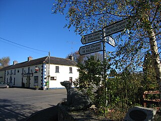
Grangecon is a village in County Wicklow, Ireland. It has a population of about 200 people, and is located between Baltinglass and Dunlavin.

History of Newtown, Connecticut

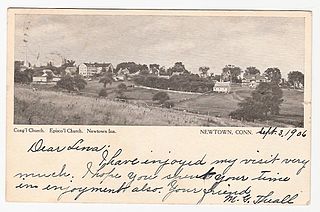
The history of Newtown, Connecticut.

St Marys, South Australia Suburb of Adelaide, South Australia

St Marys is a suburb of Adelaide, South Australia, located to the south of the Central Business District. It is bordered by Daws Road (north), South Road (west), Cashel Street (east) and Mill Terrace (south). The suburb is located within the City of Mitcham local government authority. St Marys Park is one of the largest reserves within the suburb and was originally the training ground of the South Adelaide Football Club.

Gottlob, Timiș Commune in Timiș, Romania

Gottlob is a commune in Timiș County, Romania. It is composed of two villages, Gottlob and Vizejdia. These were part of Lovrin Commune until 2004, when they were split off.

James Sheeley House

The James Sheeley House is an Italianate building in Chippewa Falls, Wisconsin, United States. Originally used as a boarding house, it is currently a restaurant.

References

  1. Guide Bulgaria, Accessed May 23, 2010