The Oropom were the aboriginal inhabitants of much of Karamoja in Uganda, Mt. Elgon area and West Pokot, Trans Nzoia and Turkana regions in Kenya. Their descendants were largely assimilated into various communities present in their former territories, including the Iteso, Karamojong, Pokot, Turkana and Bukusu. They are or were found in scattered pockets between the Turkwel River, Chemorongit Mountains and Mt. Elgon. One report indicates that they formerly spoke the unclassified Oropom language.

Kotido District is a district in Northern Uganda. It is named after its 'chief town', Kotido, where the district headquarters are located.

Moroto District is a district in the Northern Region of Uganda. The town of Moroto is the site of the district headquarters.
Nakapiripirit District is a district in Northern Uganda. Like many Ugandan districts, it is named after its 'chief town', Nakapiripirit, where the district headquarters are located.
The Karamojong or Karimojong are a Nilotic ethnic group. They are agro-pastoral herders living mainly in the north-east of Uganda. Their language is also known as ngaKarimojong and is part of the Nilotic language family. Their population is estimated at 475,000 people.

Ateker, or ŋaTekerin, is a common name for the closely related Jie, Karamojong, Turkana, Toposa, Nyangatom and Teso peoples and their languages. These ethnic groups inhabit an area across Uganda and Kenya. Itung'a and Teso have been used among ethnographers, while the term Teso-Turkana is sometimes used for the languages, which are of Eastern Nilotic stock. Ateker means 'clan' or 'tribe' in the Teso language.

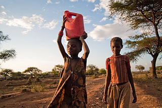
The Karamoja sub-region, commonly known as Karamoja, is a region in Uganda. It covers an area of 27,528km and comprises the Kotido District, Kaabong District, Karenga District, Nabilatuk District Abim District, Moroto District, Napak District, Amudat District and Nakapiripirit District. The region is projected to have a population of 1.4 millions in 2022 by UBOS.

Kaabong District is a district in the Northern Region of Uganda. The district headquarters are in the similarly named town of Kaabong.
Saint Mary's Seminary Nadiket, or more simply Nadiket Seminary, is a Catholic minor seminary located about 3 km (1.9 mi) from Moroto Town on the Moroto-Kitale road in Uganda. It trains young men from the dioceses of Kotido and Moroto for the Catholic priesthood

Abim District is a district in Northern Uganda. It is named after its 'chief town', Abim, where the district headquarters are located.
Abim is a town in the Northern Region of Uganda. It is the chief municipal, administrative, and commercial center of Abim District. The district is named after the town.

Kaabong is a town in the Northern Region of Uganda. It is the chief municipal, administrative and commercial center of the eponymous Kaabong District, and the district headquarters are located in the town.

Amudat District is a district in Northern Uganda. Like most Ugandan districts, it is named after its 'chief town', Amudat, where the district headquarters are located.
Napak District is a district in Northern Uganda. It is named after Mount Napak, and its headquarters is at Lokitede.
Napak is a town in Northern Uganda. It is the commercial, administrative and municipal headquarters of Napak District. The district is named after the town.
Moroto–Nakapiripirit Road is a road in the Northern Region of Uganda. The road connects the towns of Moroto, the largest town in the Karamoja sub-region, and Nakapiripirit in the same sub-region.
Soroti–Amuria–Abim–Kotido Road is a road in the Eastern and Northern Regions of Uganda. The road connects the towns of Soroti in Soroti District, to Amuria in Amuria District, Abim in Abim District, and Kotido, in Kotido District. Soroti and Amuria lie in the Teso sub-region, while Abim and Kotido are in the Karamoja sub-region.
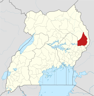
Karenga District is a district in Northern Uganda, in the Karamoja sub-region. The district headquarter is located in Karenga town. It was carved out of Kaabong District and became operational on July 1, 2019. The district has two constituencies: Dodoth West and Napore West. It borders South Sudan and Kaabong District. The population is 84,100, divided over 7 sub-counties and 3 town councils.
Rose Lilly Akello is a Ugandan politician and social worker representing Karenga District as the district woman member of parliament in the eleventh parliament of Uganda. In the ninth and tenth parliament, she served as the district woman member of parliament representing Kaabong District. Rose opted to represent Karenga District instead of Kaabong district because Karenga was carved out of Kaabong on 1 July 2019. She became the Kaabong District Woman MP after winning a by-election in 2017 against Ms Christine Tubo Nakwang. She is affiliated to the ruling political party, NRM.

The Nyangia community are a tribe in North-eastern Uganda. They live on the slopes of Nyangea Mountains, west of Kidepo Valley National Park, along the Ugandan border with South Sudan. The Nyangia are also called Nyang'i, Nyangea or Nyangiya and historically they are part of the Nilotic ethnic group largely found in Karenga Districtt in Karamoja.

