Related Research Articles

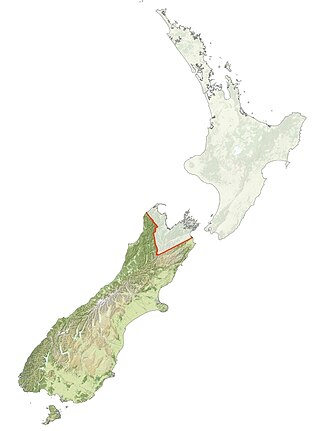
The South Island is the largest of the three major islands of New Zealand in surface area, the others being the smaller but more populous North Island and sparsely populated Stewart Island. It is bordered to the north by Cook Strait, to the west by the Tasman Sea, to the south by the Foveaux Strait and Southern Ocean, and to the east by the Pacific Ocean. The South Island covers 150,437 square kilometres (58,084 sq mi), making it the world's 12th-largest island, constituting 56% of New Zealand's land area. At low altitudes, it has an oceanic climate. The major centres are Christchurch, with a metropolitan population of 521,881, and the smaller Dunedin. The economy relies on agriculture, fishing, tourism, and general manufacturing and services.
Iwi are the largest social units in New Zealand Māori society. In Māori, iwi roughly means 'people' or 'nation', and is often translated as "tribe", or "a confederation of tribes". The word is both singular and plural in the Māori language, and is typically pluralised as such in English.

The Otago Peninsula is a long, hilly indented finger of land that forms the easternmost part of Dunedin, New Zealand. Volcanic in origin, it forms one wall of the eroded valley that now forms Otago Harbour. The peninsula lies south-east of Otago Harbour and runs parallel to the mainland for 20 km, with a maximum width of 9 km. It is joined to the mainland at the south-west end by a narrow isthmus about 1.5 km wide.
Ngāi Tahu, or Kāi Tahu, is the principal Māori iwi (tribe) of the South Island. Its takiwā is the largest in New Zealand, and extends from the White Bluffs / Te Parinui o Whiti, Mount Mahanga and Kahurangi Point in the north to Stewart Island / Rakiura in the south. The takiwā comprises 18 rūnanga corresponding to traditional settlements. According to the 2018 census an estimated 74,082 people affiliated with the Kāi Tahu iwi.

Otakou is a settlement within the boundaries of the city of Dunedin, New Zealand. It is located 25 kilometres from the city centre at the eastern end of Otago Peninsula, close to the entrance of Otago Harbour. Though a small fishing village, Otakou is important in the history of Otago for several reasons. The settlement is the modern centre and traditional home of the Ōtākou rūnanga (assembly) of Ngāi Tahu. In 1946 Otakou Fisheries was founded in the township; this was later to become a major part of the Otago fishing industry.
Kāti Māmoe is a Māori iwi. Originally from the Heretaunga Plains of New Zealand's Hawke's Bay, they moved in the 16th century to the South Island which at the time was already occupied by the Waitaha.
Waitaha is an early Māori iwi, which inhabited the South Island of New Zealand. They were largely absorbed via marriage and conquest – first by the Ngāti Māmoe and then by Ngāi Tahu – from the 16th century onward. Today those of Waitaha descent are represented by the Ngāi Tahu iwi. Like Ngāi Tahu today, Waitaha was itself a collection of various ancient iwi. Kāti Rākai was said to be one of Waitaha's hapū.

Māori mythology and Māori traditions are two major categories into which the remote oral history of New Zealand's Māori may be divided. Māori myths concern tales of supernatural events relating to the origins of what was the observable world for the pre-European Māori, often involving gods and demigods. Māori tradition concerns more folkloric legends often involving historical or semi-historical forebears. Both categories merge in whakapapa to explain the overall origin of the Māori and their connections to the world which they lived in.
The Otago region of New Zealand is one of the more isolated places of the inhabited earth. Its high latitude, elevation and distance from larger foreign and domestic population centres have defined Otago at each stage of its history.
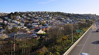
Calton Hill is an elevated southern residential suburb of the City of Dunedin in New Zealand's South Island. The suburb is named after Calton Hill in Edinburgh, Scotland, and some of its street names carry similar etymological roots.
Taare Rakatauhake Parata, also known as Charles Rere Parata, was a Māori and a Liberal Party Member of Parliament in New Zealand.

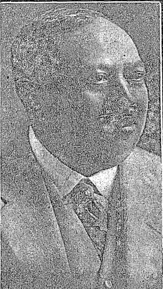
Hōri Kerei Taiaroa, also known as Huriwhenua, was a Māori member of the New Zealand parliament and the paramount chief of the southern iwi of Ngāi Tahu. The son of Ngāi Tahu leader Te Mātenga Taiaroa and Mawera Taiaroa, he was born at Ōtākou on the Otago Peninsula in the 1830s or early 1840s.
Hāriata Whakatau Pītini-Morēra was a New Zealand Māori leader, genealogist, historian and conservationist. Tipene O'Regan called her “the most important leader of Ngāti Kurī”, a subtribe of Ngāi Tahu in the South Island. With her husband Hoani Pītini-Morēra she was responsible for the preservation of many culturally important sites through the South Island, including burial grounds. She was well regarded for her knowledge of traditional weaving and also fought to preserve harakeke-growing areas.
Te Mātenga Taiaroa was a leader of Ngāi Tahu, a Māori iwi (tribe) of the South Island of New Zealand. Taiaroa belonged to Ngāi Te Ruahikihiki and Ngāti Moki hapū of Ngāi Tahu, which were centred on Taumutu, at the southern end of Lake Ellesmere / Te Waihora. From the 1830s to the 1860s, he was a leader at Ōtākou on the Otago Peninsula in association with his cousin Karetai. In the 1830s, he fought against Te Rauparaha and Ngāti Toa, sometimes in conjunction with Tūhawaiki. He was later involved in peacemaking with Ngāti Toa. In 1856 he attended the meeting of Māori chiefs at Pūkawa, Lake Taupō, which elected Pōtatau Te Wherowhero as the first Māori King. In 1860 he attended the Kohimarama conference of Māori chiefs in Auckland, organised by the government. In 1859 Taiaroa was baptised by a Methodist minister and took the Christian name of Te Mātenga (Marsden). Hōri Kerei Taiaroa was one of his children.

Southland is New Zealand's southernmost region. It consists of the southwestern portion of the South Island and includes Stewart Island. Southland is bordered by the culturally similar Otago Region to the north and east, and the West Coast Region in the extreme northwest. The region covers over 3.1 million hectares and spans 3,613 km of coastline. As of June 2023, Southland has a population of 103,900, making it the eleventh-most-populous New Zealand region, and the second-most sparsely populated. Approximately half of the region's population lives in Invercargill, Southland's only city.
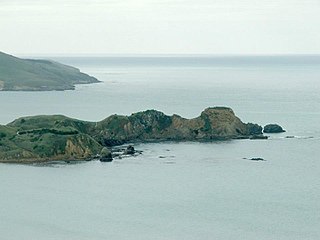
Huriawa, commonly known as Huriawa Peninsula or Karitane Peninsula, is a headland on the coast of Otago, New Zealand. It is located 35 kilometres north of Dunedin city centre, immediately to the southeast of the settlement of Karitane.
Rākaihautū was the captain of the Uruaokapuarangi canoe and a Polynesian ancestor of various iwi, most famously of Waitaha and other southern groups, though he is also known in the traditions of Taitokerau and in those of Rarotonga.

Ria Tikini or Ria Te Kini, also known as Mrs Chicken, was a New Zealand businesswoman, cultural informant and midwife. She is credited as one of the midwives who paved the way for the creation of the Plunket Society. As a Kāi Tahu and Kāti Mamoe woman, she was an informant for ethnographer William Anderson Taylor's work on Kāi Tahu history and early European contact with Māori.
Louise Magdalene Teowaina Wallscott was a Māori activist, teacher and weaver.
Khyla J. Russell is a New Zealand academic. She was appointed full professor at Otago Polytechnic on 1 February 2012 and emeritus professor at the same institution in March 2016.
References
- 1 2 3 Evison, Harry C. "Karetai". Dictionary of New Zealand Biography . Ministry for Culture and Heritage . Retrieved 3 February 2012.
- 1 2 3 4 Thomson, J. (ed.) 1998) "Southern people: A dictionary of Otago Southland biography." pp. 263–264. ISBN 1 877135 11 9
| | This biographical article relating to a Māori person is a stub. You can help Wikipedia by expanding it. |