
Arcot is a town and urban area of Ranipet district in the state of Tamil Nadu, India. Located on the southern banks of Palar River, the city straddles a trade route between Chennai and Bangalore or Salem, between the Mysore Ghat and the Javadi Hills. As of 2018, the city had a population 129,640. The sweet makkan peda is a local speciality while Arcot biryani, a rice-based traditional food, is also served here.
Vellore, also natively spelt as Velur, is a sprawling city and the administrative headquarters of Vellore district in the Indian state of Tamil Nadu. It is located on the banks of the Palar River in the northeastern part of Tamil Nadu and is separated into four zones that are further subdivided into 60 wards, covering an area of 87.915 km2 and housing a population of 423,425 as reported by the 2001 census. It is located about 137.20 kilometres (85 mi) west of Chennai, and about 213.20 kilometres (132 mi) east of Bangalore. Vellore is located on the Mumbai–Chennai arm of the Golden Quadrilateral. Vellore is governed under a mayor and the Vellore Municipal Corporation. It is a part of both the Lok Sabha and state assembly constituencies of Vellore.

Palar is a river of southern India. It rises in the Nandi Hills in Chikkaballapura district of Karnataka state, and flows 93 kilometres (58 mi) in Karnataka, 33 kilometres (21 mi) in Andhra Pradesh and 222 kilometres (138 mi) in Tamil Nadu before reaching its confluence into the Bay of Bengal at Vayalur about 75 kilometres (47 mi) south of Chennai. It flows as an underground river for a long distance only to emerge near Bethamangala town, from where, gathering water and speed, it flows eastward down the Deccan Plateau. The Towns of Bethamangala, Santhipuram, Kuppam,Mottur, Ramanaickenpet, Vaniyambadi, Ambur, Melpatti, Gudiyatham, Pallikonda, Anpoondi, Melmonavoor, Vellore, Katpadi, Melvisharam, Arcot, Ranipet, Walajapet, Kanchipuram, Walajabad, Chengalpattu, Kalpakkam, and Lattur are located on the banks of the Palar River. Of the seven tributaries, the chief tributary is the Cheyyar River.

Walajapet is a town or first municipality of Tamil Nadu and a part of Ranipet district, Vellore Metropolitan Area, in the state of Tamil Nadu. The streets in the town form a square shape which is a unique feature of the town. It will be easy for you to reach any part of the town with this kind of infrastructure. The streets are wide and nicely structured. As of 2024, the town had a population of 64,000.
Ranipettai is a town in Tamil Nadu, India and the headquarters of Ranipet district. Ranipet is an industrial hub of greater Vellore city. It is located about 100 kilometres (62 mi) from the Chennai city center. It is a major industrial town located on NH 4 Chennai-Bangalore highway, on the northern bank of the Palar River.The estimated population is 397,000 as of 2024.

Sholinghur is a municipality under Sholinghur taluk in Ranipet District of Tamil Nadu, India. The town is famous in Tamil Nadu and other neighboring states for the Lakshmi Narasimha Swamy temple.

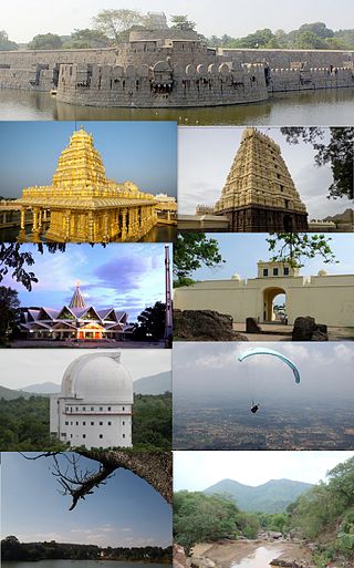
Vellore district is one of the 38 districts in the Tamil Nadu state of India. It is one of the eleven districts that form the north region of Tamil Nadu. Vellore city is the headquarters of this district. As of 2011, the district had a population of 1,614,242 with a sex ratio of 1,007 females for every 1,000 males. In 2017 Vellore district ranked eleventh in list of districts in Tamil Nadu by Human Development Index.

North Arcot was a former district in Madras Presidency, acquired by the annexation of the Arcot State in 1855 when its Nawab died without issue. It had Chittoor as its headquarters. On 1 April 1911, the Chittoor district was separated from North Arcot. The remaining district, with Vellore as its headquarters, passed intact into the Madras State of independent India. On 30 September 1989 the district was split into Tiruvannamalai-Sambuvarayar district and North Arcot Ambedkar district. It contained the present day districts of Tiruvannamalai, Vellore, Chittoor, Tirupati, Tirupattur and Ranipet.
Kalavai is a panchayat town in Ranipet district in the Indian state of Tamil Nadu. The main occupation represented in the area is farming. The town has a pond and a lake after rainy season. Villagers use the lake water and palar river for irrigation. Corporation Bank, State Bank Of India and Indian Bank are the banks that have branches in the locality. The secondary occupation is garment outlets. One government higher secondary school is also located in a nearby village.
Kaveripakkam is a town panchayat in Ranipet district in the Indian state of Tamil Nadu.
Melvisharam is a town in Ranipet district of the Indian state of Tamil Nadu. It is 7 kilometres from Ranipet, 5 km from historic town of Arcot and 17 km from Vellore city.
Nemili is a Taluk in Ranipet district of Tamil Nadu state, announced on 31 August 2015 by Tamil Nadu Chief minister Selvi J.Jayalalitha. This city, before becoming a separate taluk, it was a town panchyat under Arakkonam Taluk .This town is located in the Ranipet district about 72 kilometres from the state capital of Chennai. Nemili is supposedly one of the hottest towns in Tamil Nadu, where the temperature can exceed 43 °C (110 °F) for several days in peak of the summer. People of all religions are living in the city. The major businesses are farming, hand loom and power looms. Nemili itself is a panchayat town in Ranipet District in the Indian state of Tamil Nadu.
Aarani, officially spelled as Arni, and also known as Periya Aarani, is a major commercial, industrial and cultural hub and also a divisional headquarter in the Thiruvanamalai district of Tamil Nadu, India. The town is the second largest urban center next to the district headquarters, Thiruvannamalai, and is administered by a selection grade municipality. Aarani is home to silk weaving, spinning mills and agricultural industries. Famous Aarani silk and a paddy variety named Aarani Ponni, known for its rich aroma, originates from Aarani. The town is often nicknamed as The Silk City. Aarani also has a rich cultural heritage as it is a major center of Tamil Jainism.
Perungattur is a village located in Tiruvannamalai district, Tamil Nadu, South India. It is suburb of Cheyyar town. Its 24 km away from the temple town Kanchipuram.
Pennagar is a village in Ranipet district, Tamil Nadu. It is well known for holding quite good ratio of teachers in population. Though the transport facilities are limited to these kind of villages, it is a pride for having a higher secondary school with Her. Arni, Cheyyar and Arcot are the other major towns that are nearby. Farming is the main occupation here, supported by few rice-mills and shops here.
Tirupathur taluk is a taluk in Tirupathur district of the Indian state of Tamil Nadu. The headquarters of the taluk is the town of Tirupathur. It is known as the "Sandalwood Town" due to the abundant availability of sandalwood trees in the surrounding hills. On 15 August 2019, Chief Minister of Tamil Nadu, Edapaadi K. Palanisami announced Tirupathur district, as a new district of Tamil Nadu.
Brahmadesam is an Indian Panchayat, town panchayat village located in Vembakkam Taluk of Tiruvannamalai district in the state of Tamil Nadu. It is one of the 64 village panchayats under Vembakkam block of the Thiruvannamalai district. Brahmadesam is located on Right Bank of Palar River. The village code for Brahmadesam is 07 and it falls under the Venbakkam Block.
Ponnai is a Town panchayat which is located in the Vellore District within the state of Tamil Nadu. Ponnai Panchayat is composed of 18 villages, with Ponnai serving as the head town.
Sakkaramallur is an Indian village panchayat located in Arcot Taluk of Vellore District in the state of Tamil Nadu. Sakkaramallur is located on Right Bank of Palar River.

Ranipet district is one of the 38 districts of Tamil Nadu, India, formed by trifurcating Vellore district. The Government of Tamil Nadu has announced its proposal on 15 August 2019, together with Tirupattur district. However, it was officially declared on 28 November 2019 by Tamil Nadu Government. The town of Ranipet would serve as the district headquarters.


