
Igloolik is an Inuit hamlet in Foxe Basin, Qikiqtaaluk Region in Nunavut, northern Canada. Because its location on Igloolik Island is close to Melville Peninsula, it is often mistakenly thought to be on the peninsula. The name "Igloolik" means "there is a house here". It derives from iglu, meaning house or building, and refers to the sod houses that were originally in the area, not to snow igloos. In Inuktitut the residents are called Iglulingmiut. The mayor of Igloolik is Joe Inooya.

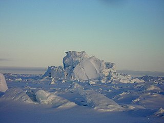
Russell Island is an uninhabited island of the Canadian Arctic Archipelago in the Qikiqtaaluk Region of Nunavut, Canada. It is located in the Parry Channel, separated from the northern tip of Prince of Wales Island by the narrow Baring Channel. The western third of the island is separated from the other two thirds by a narrow lake and its outlet. At the northern end of the lake there is an isthmus just 1.1 km (0.68 mi) wide and this joins the two parts of the island. With a total area of 940 km2 (360 sq mi), it is the largest island offshore of Prince of Wales Island.
A kayak is a personal watercraft.
Iqalugaarjuup Nunanga Territorial Park is a park located 8–10 km (5.0–6.2 mi) northwest of Rankin Inlet, Nunavut, Canada. The park is situated in the valley which straddles the Meliadine River. Access is available by foot or vehicle along a gravel road from the community of Rankin Inlet directly to the south side of the park.
The uninhabited Hamilton Island is located in Qikiqtaaluk Region, Nunavut, Canada. It is a member of the Canadian Arctic Archipelago and lies in the Parry Channel, north of Russell Island, and southwest of Young Island.
Young Island is an uninhabited member of the Canadian Arctic Archipelago in the territory of Nunavut. It lies in the Parry Channel, southwest of Lowther Island, and northeast of Hamilton Island.
Lock Island is a member of the Canadian Arctic Archipelago in the territory of Nunavut. It lies in Peel Sound across the mouth of Browne Bay, between northeastern Prince of Wales Island and northwestern Somerset Island. Vivian Island lies to the southeast, and Binstead Island to the northeast.

The Wollaston Islands are uninhabited members of the Canadian Arctic Archipelago in the territory of Nunavut. Located on the east side of the mouth of Navy Board Inlet, the island group is closer to Bylot Island than to Baffin Island.
Flattop Island is one of several uninhabited Canadian arctic islands in Kivalliq Region, Nunavut, Canada. It is located within western Hudson Bay, 26.1 km (16.2 mi) from the community of Whale Cove.
Bibby Island was named for Sir Bibby Lake, governor from 1712 to 1743. It is one of several uninhabited Canadian arctic islands in the Kivalliq Region, Nunavut, Canada. It is located within western Hudson Bay, 43.9 km (27.3 mi) from the community of Whale Cove.
Glencoe Island is a Canadian Arctic island located in Hudson Strait. It is a Baffin Island offshore island in Nunavut's Qikiqtaaluk Region.
Hector Island is an uninhabited Canadian arctic island located in Hudson Strait. It is a Baffin Island offshore island in Nunavut's Qikiqtaaluk Region.
Qaqaluit Island is one of eastern Baffin Island's small, offshore, uninhabited islands, located in the Canadian Arctic Archipelago in Qikiqtaaluk Region, Nunavut. Along with Padloping Island and Durban Island, it is situated off Cumberland Peninsula within Davis Strait's Merchants Bay.
Round Island is an uninhabited island in the Qikiqtaaluk Region of Nunavut, Canada. It is located across the mouth of Coutts Inlet in Baffin Bay off the northeastern coast of Baffin Island. Nova Zembla Island is 7.4 km (4.6 mi) to the northwest.
Low Island is one of the many uninhabited Canadian arctic islands in Qikiqtaaluk Region, Nunavut. It is a Baffin Island offshore island located in Frobisher Bay just off the Bartlett Narrows, southeast of the capital city of Iqaluit. Other islands in the immediate vicinity include Culbertson Island, Mark Island, McAllister Island, Mitchell Island, and Precipice Island.
Tourism in Nunavut focuses on outdoor activities and culture of the local Inuit, the indigenous people of Nunavut. Wildlife watching is a popular tourist attraction, as the territory is home to a number of wildlife and bird sanctuaries. It is possible to spot walrus, polar bears, a large variety of birds and belugas throughout Nunavut. Outdoor adventure activities are also popular. Nunavut has a wide and lengthy river system, meaning that there are a large number of canoeing and kayaking opportunities to suit experienced travellers. Nunavut's vast expanse of uninhabited territory offers many opportunities for hiking and camping. However, the region's often extreme conditions and remote location often necessitates a guide, even for experienced campers.
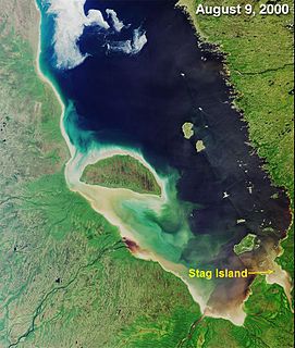
Stag Island is an uninhabited island in the southern part of James Bay, in the Qikiqtaaluk Region of Nunavut, Canada. Located at 51°39′01″N79°04′28″W, it is the southernmost island and point of land in Nunavut.


