
Victoria Island is a large island in the Canadian Arctic Archipelago that straddles the boundary between Nunavut and the Northwest Territories of Canada. It is the eighth largest island in the world, and at 217,291 km2 (83,897 sq mi) in area, it is Canada's second largest island. It is nearly double the size of Newfoundland (111,390 km2 [43,008 sq mi]), and is slightly larger than the island of Great Britain (209,331 km2 [80,823 sq mi]) but smaller than Honshu (225,800 km2 [87,182 sq mi]). It contains the world's largest island within an island within an island. The western third of the island belongs to the Inuvik Region in the Northwest Territories; the remainder is part of Nunavut's Kitikmeot Region.

Byam Martin Island (BEI-uhm) is one of the Canadian arctic islands located on the northern side of the Viscount Melville Sound in the territory of Nunavut. It is separated from the eastern coast of Melville Island, 27 km (17 mi) to the west, by the Byam Martin Channel; and from Bathurst Island, 35 km (22 mi) to the northeast, by the Austin Channel.

Russell Island is an uninhabited island of the Canadian Arctic Archipelago in the Qikiqtaaluk Region of Nunavut, Canada. It is located in the Parry Channel, separated from the northern tip of Prince of Wales Island by the narrow Baring Channel. The western third of the island is separated from the other two thirds by a narrow lake and its outlet. At the northern end of the lake there is an isthmus just 1.1 km (0.68 mi) wide and this joins the two parts of the island. With a total area of 940 km2 (360 sq mi), it is the largest island offshore of Prince of Wales Island.
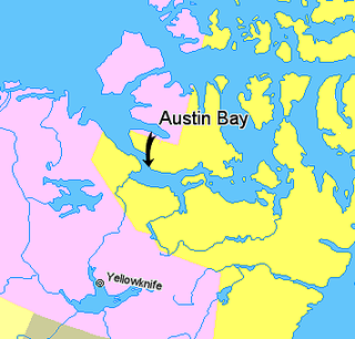
Austin Bay is an Arctic waterway in the Kitikmeot Region, Nunavut, Canada. It is located in Dolphin and Union Strait, by southwestern Victoria Island. It is separated from the Coronation Gulf by a small peninsula.
The uninhabited Hamilton Island is located in Qikiqtaaluk Region, Nunavut, Canada. It is a member of the Canadian Arctic Archipelago and lies in the Parry Channel, north of Russell Island, and southwest of Young Island.
Young Island is an uninhabited member of the Canadian Arctic Archipelago in the territory of Nunavut. It lies in the Parry Channel, southwest of Lowther Island, and northeast of Hamilton Island.
Lock Island is a member of the Canadian Arctic Archipelago in the territory of Nunavut. It lies in Peel Sound across the mouth of Browne Bay, between northeastern Prince of Wales Island and northwestern Somerset Island. Vivian Island lies to the southeast, and Binstead Island to the northeast.

Davids Island is a member of the Canadian Arctic Archipelago in the Qikiqtaaluk Region, Nunavut. It is an irregularly shaped Baffin Island offshore island, located in Admiralty Inlet, at the mouth of Fleming Inlet and Fabricius Fiord.

The Wollaston Islands are uninhabited members of the Canadian Arctic Archipelago in the territory of Nunavut. Located on the east side of the mouth of Navy Board Inlet, the island group is closer to Bylot Island than to Baffin Island.
The Byam Martin Channel is a natural waterway through the central Canadian Arctic Archipelago Qikiqtaaluk Region, Nunavut, Canada. It separates Mackenzie King Island and Melville Island from Lougheed Island, Cameron Island, Île Vanier, Massey Island and Île Marc. To the south it opens into Byam Channel and Austin Channel.
The Austin Channel is a natural waterway through the central Canadian Arctic Archipelago in the Qikiqtaaluk Region, Nunavut. It separates Byam Martin Island from Melville Island and the Alexander and Bathurst Islands. To the north it opens to the Byam Martin Channel, to the south-west to the Byam Channel, and to the south-east to the Viscount Melville Sound.
Glencoe Island is a Canadian Arctic island located in Hudson Strait. It is a Baffin Island offshore island in Nunavut's Qikiqtaaluk Region.
Hector Island is an uninhabited Canadian arctic island located in Hudson Strait. It is a Baffin Island offshore island in Nunavut's Qikiqtaaluk Region.
Qaqaluit Island is one of eastern Baffin Island's small, offshore, uninhabited islands, located in the Canadian Arctic Archipelago in Qikiqtaaluk Region, Nunavut. Along with Padloping Island and Durban Island, it is situated off Cumberland Peninsula within Davis Strait's Merchants Bay.
Round Island is an uninhabited island in the Qikiqtaaluk Region of Nunavut, Canada. It is located across the mouth of Coutts Inlet in Baffin Bay off the northeastern coast of Baffin Island. Nova Zembla Island is 7.4 km (4.6 mi) to the northwest.
Low Island is one of the many uninhabited Canadian arctic islands in Qikiqtaaluk Region, Nunavut. It is a Baffin Island offshore island located in Frobisher Bay just off the Bartlett Narrows, southeast of the capital city of Iqaluit. Other islands in the immediate vicinity include Culbertson Island, Mark Island, McAllister Island, Mitchell Island, and Precipice Island.
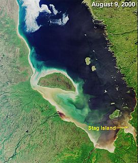
Stag Island is an uninhabited island in the southern part of James Bay, in the Qikiqtaaluk Region of Nunavut, Canada. Located at 51°39′01″N79°04′28″W, it is the southernmost island and point of land in Nunavut.


