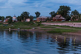
Yeniseysk is a town in Krasnoyarsk Krai, Russia, located on the Yenisei River. Population: 18,766 (2010 Census); 20,394 (2002 Census); 22,891 (1989 Soviet census); 20,000 (1970).

Bogotol is a town in Krasnoyarsk Krai, Russia, located 6 kilometers (3.7 mi) of the Chulym River and 252 kilometers (157 mi) west of Krasnoyarsk, the administrative center of the krai. Population: 21,051 (2010 Census); 24,369 (2002 Census); 27,752 (1989 Soviet census).
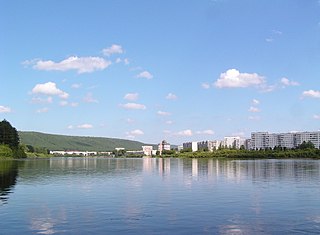
Zelenogorsk is a closed town in Krasnoyarsk Krai, Russia, located on the left bank of the Kan River 180 kilometers (110 mi) above its confluence with the Yenisei River. It was formerly known as Krasnoyarsk-45 (Красноя́рск-45) and was involved in enriching uranium for the Soviet nuclear program. Population: 66,056 (2010 Census); 69,355 (2002 Census).

Lesosibirsk is a town in Krasnoyarsk Krai, Russia, located on the Yenisei River. Population: 61,139 (2010 Census); 65,374 (2002 Census); 68,349 (1989 Soviet census).
Borodino is a town in Krasnoyarsk Krai, Russia, located 186 kilometers (116 mi) northeast of Krasnoyarsk, the administrative center of the krai. Population: 17,416 (2010 Census); 19,181 (2002 Census); 18,426 (1989 Soviet census).

Sukhobuzimsky District is an administrative and municipal district (raion), one of the forty-three in Krasnoyarsk Krai, Russia. It is located in the south of the krai. The area of the district is 5,612 square kilometers (2,167 sq mi). Its administrative center is the rural locality of Sukhobuzimskoye. Population: 20,537 (2010 Census); 23,445 (2002 Census); 25,460 (1989 Soviet census). The population of Sukhobuzimskoye accounts for 21.2% of the district's total population.

Boguchansky District is an administrative and municipal district (raion), one of the forty-three in Krasnoyarsk Krai, Russia. It is located in the east of the krai and borders with Evenkiysky District in the north, Kezhemsky District in the east, Irkutsk Oblast in the southeast, Abansky District in the south, Taseyevsky District in the southwest, and with Motyginsky District in the west. The area of the district is 53,985 square kilometers (20,844 sq mi). Its administrative center is the rural locality of Boguchany. Population: 47,968 (2010 Census); 50,503 ; 58,235 (1989 Soviet census). The population of Boguchany accounts for 23.4% of the district's total population.

Irbeysky District is an administrative and municipal district (raion), one of the forty-three in Krasnoyarsk Krai, Russia. It is located in the southwest of the krai and borders with Kansky and Ilansky Districts in the north, Irkutsk Oblast in the east and south, Rybinsky District in the southwest, and with Sayansky District in the west. The area of the district is 10,921 square kilometers (4,217 sq mi). Its administrative center is the rural locality of Irbeyskoye. Population: 16,784 (2010 Census); 19,181 ; 21,572 (1989 Soviet census). The population of Irbeyskoye accounts for 27.9% of the district's total population.

Kazachinsky District is an administrative and municipal district (raion), one of the forty-three in Krasnoyarsk Krai, Russia. It is located in the southern central part of the krai and borders with Yeniseysky and Motyginsky Districts in the north, Taseyevsky District in the east, Bolshemurtinsky District in the south, and with Pirovsky District in the west. The area of the district is 5,755 square kilometers (2,222 sq mi). Its administrative center is the rural locality of Kazachinskoye. Population: 11,430 (2010 Census); 12,732 (2002 Census); 16,015 (1989 Soviet census). The population of Kazachinskoye accounts for 33.8% of the district's total population.

Kozulsky District is an administrative and municipal district (raion), one of the forty-three in Krasnoyarsk Krai, Russia. It is located in the southwest of the krai and borders with Birilyussky District in the north, Yemelyanovsky District in the east, Balakhtinsky District in the south, and with Nazarovsky, Achinsky and Bolsheuluysky Districts in the west. The area of the district is 5,305 square kilometers (2,048 sq mi). Its administrative center is the urban locality of Kozulka. Population: 16,689 (2010 Census); 19,010 ; 22,076 (1989 Soviet census). The population of Kozulka accounts for 47.9% of the district's total population.

Novosyolovsky District is an administrative and municipal district (raion), one of the forty-three in Krasnoyarsk Krai, Russia. It is located in the southwest of the krai and borders with Balakhtinsky District in the north and east, Krasnoturansky District in the southeast, the Republic of Khakassia in the southwest and west, and with Uzhursky District in the northwest. The area of the district is 3,881 square kilometers (1,498 sq mi). Its administrative center is the rural locality of Novosyolovo. Population: 14,135 (2010 Census); 16,382 ; 17,358 (1989 Soviet census). The population of Novosyolovo accounts for 42.3% of the district's total population.

Partizansky District is an administrative and municipal district (raion), one of the forty-three in Krasnoyarsk Krai, Russia. It is located in the south of the krai and borders with Uyarsky District in the north, Rybinsky District in the northeast, Sayansky District in the east, Kuraginsky District in the south, and with Mansky District in the west. The area of the district is 4,959 square kilometers (1,915 sq mi). Its administrative center is the rural locality of Partizanskoye. Population: 10,254 (2010 Census); 12,437 ; 15,412 (1989 Soviet census). The population of Partizanskoye accounts for 34.4% of the district's total population.

Severo-Yeniseysky District is an administrative and municipal district (raion), one of the forty-three in Krasnoyarsk Krai, Russia. It is located in the center of the krai and borders with Evenkiysky District in the northwest, north, and east, Motyginsky District in the southeast, and with Yeniseysky District in the southwest and west. The area of the district is 47,242 square kilometers (18,240 sq mi). Its administrative center is the urban locality of Severo-Yeniseysky. Population: 11,119 (2010 Census); 11,077 ; 17,163 (1989 Soviet census). The population of Severo-Yeniseysky accounts for 62.5% of the district's total population.
Turukhansky District is an administrative and municipal district (raion), one of the forty-three in Krasnoyarsk Krai, Russia. It is located in the west of the krai and borders with Taymyrsky Dolgano-Nenetsky District in the north, Evenkiysky District in the east, Yeniseysky District in the south, and with Tyumen Oblast in the west. The area of the district is 211,189 square kilometers (81,541 sq mi). Its administrative center is the rural locality of Turukhansk. Population: 18,708 (2010 Census); 12,439 ; 19,257 (1989 Soviet census). The population of Turukhansk accounts for 24.9% of the district's total population.

Tyukhtetsky District is an administrative and municipal district (raion), one of the forty-three in Krasnoyarsk Krai, Russia. It is located in the southwest of the krai and borders with Yeniseysky District in the north, Birilyussky and Bolsheuluysky Districts in the east, Bogotolsky District in the south, and with Kemerovo and Tomsk Oblasts in the west. The area of the district is 9,339 square kilometers (3,606 sq mi). Its administrative center is the rural locality of Tyukhtet. Population: 8,858 (2010 Census); 10,386 ; 12,814 (1989 Soviet census). The population of Tyukhtet accounts for 54.1% of the district's total population.

Yermakovsky District is an administrative and municipal district (raion), one of the forty-three in Krasnoyarsk Krai, Russia. It is located in the south of the krai and borders with Karatuzsky District in the northeast, the Tuva Republic in the east and south, and with Shushensky District in the west and northwest. The area of the district is 17,652 square kilometers (6,815 sq mi). Its administrative center is the rural locality of Yermakovskoye. Population: 20,918 (2010 Census); 23,202 ; 23,043 (1989 Soviet census). The population of Yermakovskoye accounts for 40.9% of the district's total population.
Kedrovy is an urban locality in Yemelyanovsky District of Krasnoyarsk Krai, Russia, located 50 kilometers (31 mi) from Krasnoyarsk, the administrative center of the krai. Population: 4,692 (2010 Census); 5,223.

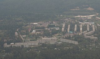
Solnechny is a closed urban locality in Krasnoyarsk Krai, Russia. As of the 2010 Census, its population was 10,384.
Krasnokamensk Urban Settlement is the name of several municipal formations in Russia.
Artyomovsk is a town in Kuraginsky District of Krasnoyarsk Krai, Russia, located 180 kilometers (110 mi) south of Krasnoyarsk. Population: 2,179 (2010 Census); 2,929 (2002 Census); 4,521 (1989 Soviet census).


