
Sibley County is a county in the South Central part of the U.S. state of Minnesota. As of the 2010 United States Census, the population was 15,226. Its county seat is Gaylord. Sibley County is part of the Minneapolis-St. Paul-Bloomington, MN-WI Metropolitan Statistical Area.

Lake of the Woods is a lake occupying parts of the Canadian provinces of Ontario and Manitoba and the U.S. state of Minnesota. It separates a small land area of Minnesota from the rest of the United States. The Northwest Angle and the town of Angle Township can be reached from the rest of Minnesota only by crossing the lake or by traveling through Canada. The Northwest Angle is the northernmost part of the contiguous United States. Its "northwesternmost point" served as a problematic landmark in treaties defining the international border.

The Boundary Waters Canoe Area Wilderness, is a 1,090,000-acre (4,400 km2) wilderness area within the Superior National Forest in northeastern part of the US state of Minnesota under the administration of the U.S. Forest Service. A mixture of forests, glacial lakes, and streams, the BWCAW's preservation as a primitive wilderness began in the 1900s and culminated in the Boundary Waters Canoe Area Wilderness Act of 1978. It is a popular destination for canoeing, hiking, and fishing, and is one of the most visited wildernesses in the United States.

Voyageurs National Park is an American national park in northern Minnesota near the town of International Falls established in 1975. The park's name commemorates the voyageurs—French-Canadian fur traders who were the first European settlers to frequently travel through the area. The park is notable for its outstanding water resources and is popular with canoeists, kayakers, other boaters, and fishermen. The Kabetogama Peninsula, which lies entirely within the park and makes up most of its land area, is accessible only by boat. To the east of the park lies the Boundary Waters Canoe Area Wilderness.

County State-Aid Highway 12 (CSAH 12), also known as the Gunflint Trail, or County Road 12 (CR 12), is a 57-mile (92 km) paved roadway and National Scenic Byway in Cook County, Minnesota, that begins in Grand Marais and ends at Saganaga Lake in the Boundary Waters Canoe Area Wilderness (BWCAW), near the U.S. border with Ontario. It provides access to many of the entry points in the BWCAW.

Kelso Conservation Area is located near Milton, Ontario and is owned and operated by Conservation Halton. This park has an area of 3.97 square kilometres and contains Lake Kelso which was built for flood control of Sixteen Mile Creek and has a sandy beach for swimmers in the summer with a food concession and board walk along the lake to the Boat Rental shop which offers the rentals of canoes, kayaks, paddle boards, paddle boats and is also open to any non-motorized watercraft. The Park also offers 20 campsites, 18 reserve-able picnic sites, and two camping/picnic mixed sites. Glen Eden Ski & Snowboard Centre is located in the park and offers downhill skiing, snowboarding and tubing during the winter months. In addition, the Halton Region Museum is also located on the Kelso grounds. The park also features marked mountain biking and hiking trails.
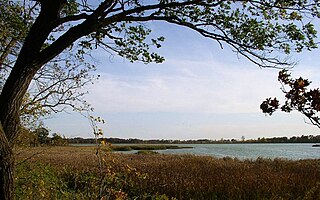
Rice Lake State Park is a state park of Minnesota, United States, just east of Owatonna. Park lands entirely surround Rice Lake, an important stopping point for migrating waterfowl. The lake covers 750 acres (300 ha) with an average depth of 3 feet (1 m).
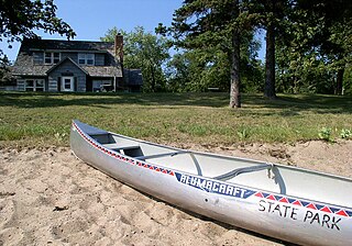
Glendalough State Park is a state park of Minnesota, USA, in Otter Tail County near Battle Lake close to Minnesota State Highway 78. It is named after Glendalough in Ireland. The park was once used as a resort and game farm by the owners of Cowles Media Company, owner of what is today the Star Tribune newspaper. The park contains 1,931 acres (7.81 km2) on land and 1,000 acres (4.0 km2) on the water. Cowles Media Company transferred title to Glendalough to the Nature Conservancy in 1990, and the Nature Conservancy transferred title to the State of Minnesota in 1992. Glendalough was officially declared a state park with a celebration on Earth Day, April 22, 1992.
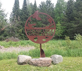
Moose Lake State Park is a state park of Minnesota, USA, near the city of Moose Lake, MN in Carlton County. The park is located one-half mile east of Interstate 35 at the 214 exit. The park entrance is off of County Highway 137. Moose Lake State Park was established in 1971. In total, the park is 1,194 acres in area. Some of the highlights of the park include 5.5 miles of hiking trails, a 105-acre Echo Lake, wildlife pond, paved trail to Moose Lake and Willard Munger State Trail, and Agate/Geological Interpretive Center; located within the park office.
Sawbill Lake is a lake in Cook County, Minnesota. The closest town to Sawbill Lake is Tofte. It is a popular entry point to the Boundary Waters Canoe Area Wilderness in the Superior National Forest. Sawbill is a nickname of the common merganser duck. There is a United States Forest Service cabin, a canoe outfitter, and a campground located at the southern end of the lake. During the Great Depression there was a Civilian Conservation Corps camp six miles south of the lake.

Rattlesnake Point is an eco-tourism area located in Milton, Ontario, Canada and is owned and operated by Conservation Halton. Spanning roughly one-hundred square kilometres across and near the Niagara Escarpment in Halton Region, the Rattlesnake Point area is home to many golf courses, country markets and equestrian training and boarding facilities. It is a popular scouting area.

Whale Lake is a lake in Cook County in what is known as the Arrowhead Region of northern Minnesota. It is within the Boundary Waters Canoe Area Wilderness of the Superior National Forest, at the base of Eagle Mountain, Minnesota's highest point. Two miles (3 km) from the nearest road, Whale Lake is only accessible via the Eagle Mountain Hiking Trail from the south, or the Brule Lake Trail from the northwest. It offers two campsites to hikers, one on the northern shore near the intersection of the two trails, and the other a few hundred yards away from the western shore.

Indian Lake is a 12-mile (19 km) long, 4,255-acre (1,722 ha) reservoir with a southwest to northeast orientation in the towns of Indian Lake and Lake Pleasant in Hamilton County, in the Adirondack Park of New York State, in the United States. The hamlet of Indian Lake is located 2 miles (3.2 km) north of the north end of Indian Lake. New York State Route 30 runs along the west shore of the lake. Most of the shore is part of the Forest Preserve. Indian Lake is fed by the Jessup River, and drains through the Indian River into Lake Abanakee, and from there through the Indian River to the Hudson River.

The Kelso Depot, Restaurant and Employees Hotel or Kelso Depot, now also the Mojave National Preserve Visitors Center, is located in the Mojave Desert within the National Park Service Mojave National Preserve, on Kelso Cima Road at the junction of Kelbaker Road in Kelso, California, between Baker and Interstate 15 to the north and Interstate 40 to the south. It was placed on the National Register of Historic Places, and along with the adjacent ghost town of Kelso, was declared a United States Historic District in 2000. The district was increased by a boundary increase approved by the National Park Service in 2019, with reference number 100003401.
Headquartered in Hermantown, Minnesota, Voyageurs Area Council serves Scouts in Minnesota, Wisconsin, and Michigan. The Ka'niss Ma'ingan Lodge is the local Order of the Arrow Lodge for Voyageurs Area Council.

The Emily State Forest is a state forest located near the town of Emily in the Crow Wing County, Minnesota. With an area of 639 acres (259 ha), it is the smallest state forest in Minnesota. In addition to hiking and hunting, backcountry camping is allowed within the forest, defined campsites are located at the nearby Crow Wing State Forest and Land O'Lakes State Forest.
The Kabetogama State Forest is a state forest located in Koochiching and Saint Louis counties, Minnesota, United States. The forest borders the Superior National Forest and the Boundary Waters Canoe Area Wilderness to the east, the Sturgeon River State Forest to the south, the Nett Lake Indian Reservation to the west, and Voyageurs National Park to the north. The forest is managed by the Minnesota Department of Natural Resources.
The Land o' Lakes State Forest is a state forest located primarily in Cass, Minnesota, with portions extending into adjacent Aitkin and Crow Wing counties. The forest has small shared borders with the Chippewa National Forest to the north, and the Hill River State Forest to east. Over half of the forest's land is managed by the Minnesota Department of Natural Resources; the remaining land is managed by Cass County or is privately held.
Smoke Lake is a lake in Cook County, Minnesota within Tofte Township. It is within the Boundary Waters Canoe Area Wilderness and the Superior National Forest. The lake can be accessed by a 100 rods (500 m) portage from Sawbill Lake to the west and a 90 rods (450 m) portage from Burnt Lake to the east, which in turn is accessed from Entry Point 39 at Baker Lake through Peterson and Kelly lakes.

