Related Research Articles
Worland Municipal Airport is in Washakie County, Wyoming, three miles south of Worland, which owns it. It was built in 1953. It has no scheduled airline service; Great Lakes Airlines pulled out on September 30, 2016.

Alturas Municipal Airport, is a city-owned public-use airport located one nautical mile (1.85 km) west of the central business district of Alturas, a city in Modoc County, California, United States. This airport is included in the FAA's National Plan of Integrated Airport Systems for 2009–2013, which categorizes it as a general aviation facility.
Clarion Municipal Airport is a city-owned public-use airport located one nautical mile (1.85 km) northwest of the central business district of Clarion, a city in Wright County, Iowa, United States. This airport is included in the FAA's National Plan of Integrated Airport Systems for 2009–2013, which categorized it as a general aviation facility.

Ambler Airport is a state-owned public-use airport located one nautical mile (1.85 km) north of the central business district of Ambler, a city in the Northwest Arctic Borough of the U.S. state of Alaska.
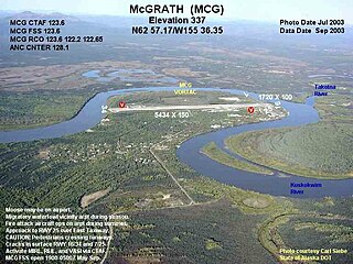
McGrath Airport is a state-owned public-use airport serving McGrath, a city in the Yukon-Koyukuk Census Area of the U.S. state of Alaska.

Lea County Jal Airport is a county-owned public-use airport located three nautical miles northeast of the central business district of Jal, a city in Lea County, New Mexico, United States.

Wetumpka Municipal Airport is a city-owned, public-use airport located six nautical miles west of the central business district of Wetumpka, a city in Elmore County, Alabama, United States. It is included in the FAA's National Plan of Integrated Airport Systems for 2011–2015, which categorized it as a general aviation facility. During World War II the airport, known then as Elmore Auxiliary Field, served as an auxiliary field for Gunter Army Airfield training operations. In 2013 the airport was listed in the Alabama Register of Landmarks and Heritage.

Florala Municipal Airport is a city-owned public-use airport located three nautical miles northeast of the central business district of Florala, a city in Covington County, Alabama, United States.

Posey Field is a city-owned public-use airport located three nautical miles northeast of the central business district of Haleyville, a city in Winston County, Alabama, United States.

Headland Municipal Airport is a city-owned, public-use airport located two nautical miles northeast of the central business district of Headland, a city in Henry County, Alabama, United States.

South Naknek Airport, also known as South Naknek Nr 2 Airport, is a state-owned public-use airport located one nautical mile (1.85 km) southwest of the central business district of South Naknek, in the Bristol Bay Borough of the U.S. state of Alaska.
Afton Municipal Airport is a town-owned, public-use airport located one nautical mile southwest of the central business district of Afton, a town in Lincoln County, Wyoming, United States. It is also known as Afton-Lincoln County Airport.
Almyra Municipal Airport is a city-owned, public-use airport located three nautical miles west of the central business district of Almyra, a city in Arkansas County, Arkansas, United States. This airport is included in the FAA's National Plan of Integrated Airport Systems for 2009–2013, which categorizes it as a general aviation facility.
Red Oak Municipal Airport is a city-owned public-use airport located two nautical miles (3.7 km) west of the central business district of Red Oak, a city in Montgomery County, Iowa, United States. According to the FAA's National Plan of Integrated Airport Systems for 2009–2013, it is categorized as a general aviation facility.
Stevensville Municipal Airport is a town-owned public-use airport located two nautical miles northeast of the central business district of Stevensville, a town in Ravalli County, Montana, United States. According to the FAA's National Plan of Integrated Airport Systems for 2009–2013, it is categorized as a general aviation facility.
Nondalton Airport is a state-owned public-use airport located one nautical mile (1.85 km) northwest of the central business district of Nondalton, in the Lake and Peninsula Borough of the U.S. state of Alaska.
Platinum Airport is a state-owned public-use airport located in Platinum, in the Bethel Census Area of the U.S. state of Alaska.
St. Johns Industrial Air Park is a city-owned public-use airport located 1.15 miles north of the central business district of St. Johns, a city in Apache County, Arizona, United States. The airport is included in the FAA's National Plan of Integrated Airport Systems for 2009–2013, which categorizes it as a general aviation facility. The NPIAS report for 2015–2019 classified the Air Park again as General Aviation, in the "Basic" asset category, for airports with the lowest levels of activity.
Orange City Municipal Airport was a city-owned public-use airport located one nautical mile (1.85 km) south of the central business district of Orange City, a city in Sioux County, Iowa, United States. This airport was included in the FAA's National Plan of Integrated Airport Systems for 2009–2013, which categorized it as a general aviation facility.
Torrington Municipal Airport is two miles east of Torrington, in Goshen County, Wyoming. The National Plan of Integrated Airport Systems for 2011–2015 categorized it as a general aviation facility.
References
- 1 2 3 4 FAA Airport Form 5010 for EMM PDF , effective September 7, 2023.
- ↑ FAA National Plan of Integrated Airport Systems: 2009-2013. Federal Aviation Administration. Published 1 Oct 2008.