
Kern County is a county located in the U.S. state of California. As of the 2020 census, the population was 909,235. Its county seat is Bakersfield.

Tulare County is a county located in the U.S. state of California. As of the 2020 census, the population was 473,117. The county seat is Visalia. The county is named for Tulare Lake, once the largest freshwater lake west of the Great Lakes. Drained for agricultural development, the site is now in Kings County, which was created in 1893 from the western portion of the formerly larger Tulare County.
Buena Vista, meaning "good view" in Spanish, may refer to:

Tulare Lake or Tache Lake is a freshwater lake in the southern San Joaquin Valley, California, United States. Historically, Tulare Lake was once the largest freshwater lake west of the Mississippi River. For thousands of years, from the Paleolithic onward, Tulare Lake was a uniquely rich area, which supported perhaps the largest population of Native Americans north of present-day Mexico.

The Governor Edmund G. Brown California Aqueduct is a system of canals, tunnels, and pipelines that conveys water collected from the Sierra Nevada Mountains and valleys of Northern and Central California to Southern California. Named after California Governor Edmund Gerald "Pat" Brown Sr., the over 400-mile (640 km) aqueduct is the principal feature of the California State Water Project.

The Kern River is an Endangered, Wild and Scenic river in the U.S. state of California, approximately 165 miles (270 km) long. It drains an area of the southern Sierra Nevada mountains northeast of Bakersfield. Fed by snowmelt near Mount Whitney, the river passes through scenic canyons in the mountains and is a popular destination for whitewater rafting and kayaking. It is the southernmost major river system in the Sierra Nevada, and is the only major river in the Sierra that drains in a southerly direction.
The California Central Valley grasslands is a temperate grasslands, savannas, and shrublands ecoregion in California's Central Valley. It a diverse ecoregion containing areas of desert grassland, prairie, savanna, riparian forest, marsh, several types of seasonal vernal pools, and large lakes such as now-dry Tulare Lake, Buena Vista Lake, and Kern Lake.

The Yokuts are an ethnic group of Native Americans native to central California. Before European contact, the Yokuts consisted of up to 60 tribes speaking several related languages. Yokuts is both plural and singular; Yokut, while common, is erroneous. 'Yokut' should only be used when referring specifically to the Tachi Yokut Tribe of Lemoore. Some of their descendants prefer to refer to themselves by their respective tribal names; they reject the term Yokuts, saying that it is an exonym invented by English-speaking settlers and historians. Conventional sub-groupings include the Foothill Yokuts, Northern Valley Yokuts, and Southern Valley Yokuts.

The ornate shrew is a species of mammal in the family Soricidae (shrews). It is endemic to western North America, ranging from Northern California in the United States to the Baja California peninsula in Mexico. Eight subspecies are known, including the extinct tule shrew, known only from four specimens collected in 1905, and the Suisun ornate shrew, a species of conservation concern in California. Through skull morphology research and genetic testing on Ornate shrew populations, it has been shown that there are three main genetic subdivisions: The Southern, Central and Northern. These three genetic subdivisions of Ornate shrew arose from populations of Ornate shrews getting geographically isolated from other populations.

Buena Vista was a Yokuts language of California. It was spoken in at least two local varieties around Buena Vista Lake in Kern County, California," in the villages of Hometwoli, Loasau, Tuhohi, and Tulamni.
Chico Martinez Creek, formerly Arroyo Chico Martinez is a stream with its source located in the Temblor Range in Kern County, California near to the San Luis Obispo County boundary. Its source is located 10.7 miles north of Soda Lake, California in the middle of the Carrizo Plain. The creek runs generally east and northeast to terminate just east of the South Belridge Oil Field. In years of heavy rainfall it may have been a tributary to the Kern River between Buena Vista Lake and Tulare Lake.

San Emigdio Creek, formerly Arroyo de San Emigdio, is a 33 kilometres (21 mi) northward-flowing stream in western Kern County, central California.

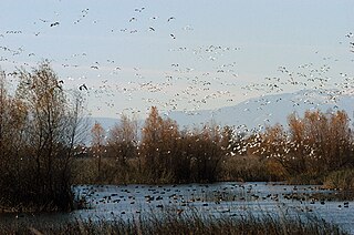
Buena Vista Lake was a fresh-water lake in Kern County, California, in the Tulare Lake Basin in the southern San Joaquin Valley, California.
Connecting Slough, the former slough between Kern Lake and Buena Vista Lake in the southeastern San Joaquin Valley, in Kern County, California.
Poso Creek or Posey Creek is an 87.9-mile (141.5 km) intermittent stream in Kern County, California.
Buena Vista Slough was the joint outlet of an overflowing Buena Vista Lake and a distributary of the Kern River into Tulare Lake. It is now diverted into a system of canals by the Outlet Canal of the Central Valley Project.
Lux v. Haggin, 69 Cal. 255; 10 P. 674; (1886), is a historic case in the conflict between riparian and appropriative water rights. Decided by a vote of four to three in the Supreme Court of California, the ruling held that appropriative rights were secondary to riparian rights.
Buena Vista County was a failed attempt to create a county from the territory of Tulare County, California, between 1855 and 1859.
Hometwoli was a dialect of Buena Vista Yokuts spoken in the southern portion of the Tulare Basin of California near Kern Lake.
Sacramento–San Joaquin is a freshwater ecoregion in California. It includes the Sacramento and San Joaquin river systems of California's Central Valley, which converge in the inland Sacramento–San Joaquin Delta. It also includes the mostly-closed Tulare Lake basin in the southern Central Valley, the rivers and streams that empty into San Francisco Bay, and the Pajaro and Salinas river systems of Central California which empty into Monterey Bay.


