
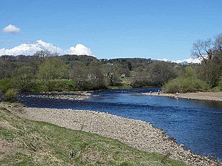
The River Tyne is a river in North East England. Its length is 73 miles (118 km). It is formed by the North Tyne and the South Tyne, which converge at Warden Rock near Hexham in Northumberland at a place dubbed 'The Meeting of the Waters'.

The Tyne Bridge is a through arch bridge over the River Tyne in North East England, linking Newcastle upon Tyne and Gateshead. The bridge was designed by the engineering firm Mott, Hay and Anderson, who later designed the Forth Road Bridge, and was built by Dorman Long and Co. of Middlesbrough. The bridge was officially opened on 10 October 1928 by King George V and has since become a defining symbol of Tyneside. It is ranked as the tenth tallest structure in the city.

The A69 is a major northern trunk road in England, running east–west across the Pennines, through the counties of Tyne and Wear, Northumberland and Cumbria. Originally, the road started in the centre of Newcastle upon Tyne then later near Birtley, but since the creation of the A1 Western Bypass around Newcastle upon Tyne, it now starts at Denton Burn, a suburb of Newcastle upon Tyne.

The Castle, Newcastle, or Newcastle Castle is a medieval fortification in Newcastle upon Tyne, England, built on the site of the fortress that gave the City of Newcastle its name. The most prominent remaining structures on the site are the Castle Keep, the castle's main fortified stone tower, and the Black Gate, its fortified gatehouse.

Haydon Bridge is a village in Northumberland, England, with a population of about 2000, the civil parish Haydon being measured at 2,184 in the Census 2011. Its most distinctive features are the two bridges crossing the River South Tyne: the picturesque original bridge for which the village was named and a modern bridge which used to carry the A69 road. A bypass was completed in 2009 and the A69 now bypasses the village to the south.

The history of Newcastle upon Tyne dates back almost 2,000 years, during which it has been controlled by the Romans, the Angles and the Norsemen amongst others. Originally known by its Roman name Pons Aelius, the name "Newcastle" has been used since the Norman conquest of England. Due to its prime location on the River Tyne, the town developed greatly during the Middle Ages and it was to play a major role in the Industrial Revolution, being granted city status in 1882. Today, the city is a major retail, commercial and cultural centre.
Ovingham is a civil parish and village in the Tyne Valley of south Northumberland, England. It lies on the River Tyne 10 miles (16 km) east of Hexham with neighbours Prudhoe, Ovington, Wylam and Stocksfield.

The Queen Alexandra Bridge is a road traffic, pedestrian and former railway bridge spanning the River Wear in North East England, linking the Deptford and Southwick areas of Sunderland. The steel truss bridge was designed by Charles A. Harrison. It was built by Sir William Arrol between 1907 and 1909 and officially opened by The Earl of Durham, on behalf of Queen Alexandra on 10 June 1909.
The Redheugh Bridge is a road bridge spanning the River Tyne west of Newcastle upon Tyne city centre on the north bank and Gateshead town centre on the south bank, in North East England. It currently carries the A189 road.

Pons Aelius, or Newcastle Roman Fort, was an auxiliary castra and small Roman settlement on Hadrian's Wall in the Roman province of Britannia Inferior, situated on the north bank of the River Tyne close to the centre of present-day Newcastle upon Tyne, and occupied between the 2nd and 4th centuries AD.

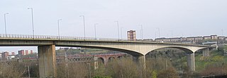
Scotswood Bridge is one of the main bridges crossing the River Tyne in North East England. It links the west end of Newcastle upon Tyne on the north bank of the river with the MetroCentre and Blaydon in Gateshead on the south bank. It is situated 5.2 km (3.2 mi) upstream of the better-known city centre bridges.

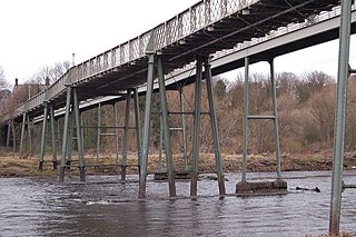
Scotswood Railway Bridge is a pipeline bridge and former railway bridge crossing the River Tyne in North East England. It previously carried the Newcastle and Carlisle Railway between Scotswood and Blaydon stations.

Victoria Viaduct, originally known as the Victoria Bridge, is a stone arch rail viaduct spanning the River Wear about 1 mile (1.6 km) south-east of Washington in North East England. It was built as part of the Durham Junction Railway under the supervision of Thomas Elliot Harrison.
Warden is a village in Northumberland, England about 2 miles (3 km) west of Hexham.
Chesters Bridge was a Roman bridge over the River North Tyne at Chollerford, Northumberland, England, and adjacent to the Roman fort of Cilurnum on Hadrian's Wall. The fort, mentioned in the Notitia Dignitatum, and now identified with the fort found at Chesters, was known as Cilurnum or Cilurvum.

The Victoria Jubilee Bridge, also known as Victoria Bridge, is a road bridge carrying Bridge Road (A1130) east west across the River Tees between Stockton-on-Tees and Thornaby-on-Tees in the borough of Stockton-on-Tees in the north east of England. Commonly referred to as the Victoria Bridge, it is located just south east of Stockton town centre.

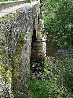
Lambley Viaduct is a stone bridge across the River South Tyne at Lambley in Northumberland. Formerly a railway bridge, it remains open to pedestrians but one end of the viaduct has been fenced off.

Bellingham Bridge is a stone bridge across the River North Tyne at Bellingham in Northumberland, England.

Alston Arches Viaduct, also known as Haltwhistle Viaduct, is a stone bridge across the River South Tyne at Haltwhistle in Northumberland, England.
Falstone Bridge is a stone bridge across the River North Tyne at Falstone in Northumberland.

