
Mount Charleston, including Charleston Peak at 11,916 feet (3,632 m), is the highest mountain in both the Spring Mountains and Clark County, in Nevada, United States. It is the eighth-highest mountain in the state. Well separated from higher peaks by large, low basins, Charleston Peak is the most topographically prominent peak in Nevada, and the eighth-most-prominent peak in the contiguous United States. It is one of eight ultra-prominent peaks in Nevada. It is located about 35 miles (56 km) northwest of Las Vegas within the Mount Charleston Wilderness, which is within the Spring Mountains National Recreation Area of the Humboldt–Toiyabe National Forest.

Serles is a mountain of the Stubai Alps in the Austrian state of Tyrol, Austria, between the Stubai Valley and Wipptal, near the Italian border. Its nickname is Altar von Tirol, literally the Altar of Tyrol. It has several lower peaks, including Sonnenstein to the north.

The Zuckerhütl is a mountain in Tyrol, Austria. At 3,505 metres, it is the highest peak of the Stubai Alps and lies at the southern end of the Stubaital Valley.

The Rosengartenspitze is a mountain in the Dolomites in South Tyrol, Italy.

The Rosengarten group is a massif in the Dolomites of northern Italy. It is located between the Tierser Tal and Eggental in South Tyrol and the Fassa Valley in Trentino.

The Dreiherrnspitze, at 3,499 m (11,480 ft) above mean sea level, is a mountain on the tripoint between the Austrian states of Salzburg and Tyrol, and South Tyrol in Italy. It is part of the Venediger Group in the Hohe Tauern range of the Central Eastern Alps and the Alpine divide.

Hasenöhrl is a mountain of the Ortler Alps in South Tyrol, Italy.
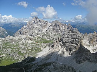
The Dreischusterspitze is a mountain of the Dolomites in South Tyrol, Italy. It is the highest peak of the Sexten Dolomites and the most northerly 3,000m peak of the range. From the north it resembles a majestic pyramid, while from the east and west it resembles a jagged ridge. The mountain is located above the village of Sexten. It was first climbed in 1869 by Paul Grohmann, Franz Innerkofler and Peter Salcher.

The Saslonch, Sassolungo or Langkofel (3,181m) is the highest mountain of the Langkofel Group in the Dolomites in South Tyrol, Italy. The name translates to "long peak" / "long rock" in all three languages. It stands over the Ladin community of Val Gardena.

The Latemar is a mountain in the Dolomites on the border between South Tyrol and Trentino, Italy. It is a popular hiking destination. It is best known for its view from the Karersee lake.
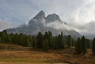
The Peitlerkofel is a mountain of the Dolomites in South Tyrol, Italy. A solitary mountain, it stands between Val Badia to the east and the Villnöß valley to the west, in the very north of the Dolomites. It boasts two distinct summits, the Grosser Peitler (2875m) and the Kleiner Peitler (2813m), which are divided by a deep ridge.

The Hochgolling is a mountain of the Eastern Alps, located on the border of Steiermark and Salzburg, Austria, near the ski resort of Schladming. It is the highest peak of the Lower Tauern range.

The Gailtaler Polinik is a mountain, 2,332 m above sea level (AA), in the Carnic Alps in the Austrian state of Carinthia. It lies on the main ridge of the Carnics and is the highest peak of the Eastern group.

The Hochalmspitze is located east of Mallnitz in the Austrian state of Carinthia. It is sometimes called "Tauern Queen" as a counterpart to the "Tauern King", the Grossglockner.

Aiguille de Chambeyron (3,412m) is a mountain of the Cottian Alps and is the highest mountain of Alpes-de-Haute-Provence in southeast France. Together with its neighbour Brec de Chambeyron, it is the dominant peak of the upper Ubaye Valley. The mountain is located near the border with Italy, just west of the Main chain of the Alps. It is the culminating point of the Massif du Chambeyron and is also the highest peak in the Alps south of Monte Viso.

Hohe Gaisl, (3,146m) is a mountain in the northern Dolomites, on the border of South Tyrol and Veneto, in northern Italy, located between the Braies Valley and the Val di Landro.

Tofana di Rozes is a mountain of the Dolomites in the Province of Belluno, Veneto, Italy. Located west of the resort of Cortina d'Ampezzo, the mountain's giant three-edged pyramid shape and its vertical south face, above the Falzarego Pass, makes it the most popular peak in the Tofane group, and one of the most popular in the Dolomites.

The Daniel is a mountain in the Austrian state of Tyrol, and the highest peak in the Ammergau Alps, a range within the Northern Limestone Alps . Located near the villages of Ehrwald and Lermoos, it is a popular mountain with hikers. Its North Face is around 200 metres high and its South Face has a more schrofen-like character. With the almost equally high Upsspitze (2,332 m) it forms a double summit. To the northwest is a neighbouring peak, the Hochschrutte (2,247 m).

Trogkofel is a mountain of the Carnic Alps lying on the border of Friuli, Italy and Carinthia, Austria. It is located on the main ridge of the Carnics between the Aip Valley to the south and the Gail Valley in the north, and is the second highest mountain on the eastern ridge after Gailtaler Polinik. The mountain is known as Crete Rosse, meaning Red Rocky Mountain in Friuli.
Tule Peak is a summit located in the northwest part of the state of Nevada, United States in the county region of Washoe. It is the highest peak in the Virginia Mountains with a height of 2659.7m.

