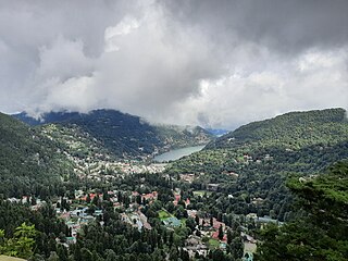
Nainital is a city and headquarters of Nainital district of Kumaon division, Uttarakhand, India. It is the judicial capital of Uttarakhand, the High Court of the state being located there and is the headquarters of an eponymous district. It also houses the Governor of Uttarakhand, who resides in the Raj Bhavan. Nainital was the summer capital of the United Provinces.

Champawat is a town and a Nagar Palika Parishad in Champawat district in the state of Uttarakhand, India. It is the administrative headquarters of Champawat district. The town was the former capital of the Kumaon Kingdom.

Uttarakhand, also known as Uttaranchal, is a state in the northern India. It is often referred to as the "Devbhumi" due to its religious significance and numerous Hindu temples and pilgrimage centres found throughout the state. Uttarakhand is known for the natural environment of the Himalayas, the Bhabar and the Terai regions. It borders the Tibet Autonomous Region of China to the north; the Sudurpashchim Province of Nepal to the east; the Indian states of Uttar Pradesh to the south and Himachal Pradesh to the west and north-west. The state is divided into two divisions, Garhwal and Kumaon, with a total of 13 districts. The winter capital of Uttarakhand is Dehradun, the largest city of the state, which is a rail head. Bhararisain, a town in Chamoli district, is the summer capital of Uttarakhand. The High Court of the state is located in Nainital, but is to be moved to Haldwani in future.

Haldwani is the largest city of Kumaon. It is also the third most populous city and largest commercial market in the Indian state of Uttarakhand. Haldwani is said to be the financial capital of Uttarakhand, having the most commercial, economic and industrial activities of the state. Haldwani is located in the Nainital District, and is one of its eight Subdivisions. The Haldwani Urban agglomeration has 232,060 people as of 2011, and is the third most populous UA in Uttarakhand, after Dehradun and Haridwar. Being situated in the immediate foothills of Kumaon Himalayas, the Kathgodam neighbourhood of Haldwani is known as the "Gateway to Kumaon".

Ranikhet is a hill station and cantonment town, nearby Almora Town in Almora district in the Indian state of Uttarakhand. It is the home for the Military Hospital, Kumaon Regiment (KRC) and Naga Regiment and is maintained by the Indian Army.
Gairsain is a town in Chamoli district of the Indian state of Uttarakhand near state's summer capital Bhararisain. A town and Nagar Panchayat, Gairsain is situated at the eastern edge of the vast Dudhatoli mountain range, and is located in Chamoli district almost at the centre of the state, at a distance of approximately 250 kilometres from Dehradun. It is easily accessible from both the Garhwal and the Kumaon divisions, and in a way, acts as the bridge between the two regions. It is being considered as the future Permanent capital of Uttarakhand.

Nainital district is a district in Kumaon division which is a part of Uttarakhand state in India. The headquarters is at Nainital.

Pithoragarh is a Himalayan town with a Municipal Board in Pithoragarh district in the Indian state of Uttarakhand. It is the fourth largest town of Kumaon and the largest in Kumaon hills. It is an education hub of the hilly region as the town has Laxman Singh Mahar Govt.P.G.College, Seemant Institute of Technology, now known as Nanhi Pari Seemant Engineering Institute and a nursing college.
Bageshwar is a town and a municipal board in Bageshwar district in the state of Uttarakhand, India. It is located at a distance of 470 km from the National Capital New Delhi and 332 km from the State Capital Dehradun. Bageshwar is known for its scenic environment, glaciers, rivers and temples. It is also the administrative headquarters of Bageshwar district.

Kathgodam is a suburb of Haldwani city in the Nainital district of Uttarakhand state of India. It used to be a part of the twin township of Haldwani-Kathgodam, and is immediately north of Haldwani. It is one of the important collection centres for forest products obtained from Kumaon Himalayas.

Pantnagar is a town and a university campus in Udham Singh Nagar District, Uttarakhand. Nainital, Kashipur, Rudrapur, Kiccha and Haldwani are the major cities surrounding Pantnagar.
Kashipur is a city of Udham Singh Nagar district in the Indian state of Uttarakhand, and one of its seven subdivisions. Located in the western part of Udham Singh Nagar district, it is Kumaun's third most populous city and the sixth most populous in Uttarakhand. According to the 2011 Census of India, the population is 121,623 for the city of Kashipur and 283,136 for Kashipur Tehsil. Kashipur also has IIM Kashipur, one of the thirteen Indian Institutes of Managements the government has set up during the Eleventh Five-year Plan.

Bhowali[bʱəʋaːli] is a town and a municipal board in Nainital District in the state of Uttarakhand, India. It is situated at a distance of 11 km (6.8 mi) from the city of Nainital, the district headquarters; at an average elevation of 1,654 m (5,427 ft) from sea level. It is the seat of Bhowali tehsil, one of the eight subdivisions of Nainital district.

Ramnagar is a town and municipal board in the Nainital district of Kumaon, India. It is located approximately 65 kilometres (40 mi) from Nainital, the headquarters of the district.

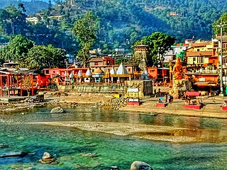
Baijnath is a small town on the banks of the Gomati river in the Bageshwar district in Kumaon division of Uttarakhand, India. The place is most noted for its ancient temples, which have been recognized as Monuments of National Importance by the Archaeological Survey of India in Uttarakhand. Baijnath has been selected as one of the four places to be connected by the 'Shiva Heritage Circuit' in Kumaon, under the Swadesh Darshan Scheme of the Government of India.

Ashok Hall Girls' Residential School is a private girls' school located in Ranikhet, Almora District, India. The school was established in 1993. The school provides education and residential facilities to students from classes 4 through 12.
Katarmal is a remote village located in Kumaon Division, in Almora District, Uttarakhand, India.
Betalghat is a small town and tehsil in Nainital district, Uttarakhand, India. As of 2011, it had a total population of 21265 spread over 4357 households.
Mankot is a Village situated in Bageshwar district in the State of Uttarakhand, India. It is located at a distance of 13.5 kilometres (8.4 mi) from Bageshwar on the National Highway 309A. Mankot is a medium-sized village with total 118 families residing.

Kautik International Student Film Festival is a 10-day competitive international student film festival, organised by CEFM-the Hermitage, Kumaun University, Nainital, Uttarakhand, in association with the Himalayan Society for Art, Culture, Education, Environment and Film Development (HIMACEEF) promoted by filmmakers/academicians Rajesh Shah and National Award winning documentary filmmaker Shalini Shah. The duo are film faculty members at the University. The festival is attended by students, theatre artistes, cinematographers, filmmakers and ministers.


