Handwara is a sub-district and a town in Kupwara district of Kashmir. It was known as Uttar Machipora until the division of Baramulla district in the 1980s resulting in the formation of two new districts: Kupwara and Bandipora. It is located on Baramulla-Handwara National Highway NH-701 and is governed by a municipal committee.
Kupwara is a town and a municipal council in Kupwara district in the Indian union territory of Jammu and Kashmir.

Pampore, known as Pampar or Panpar in Kashmiri, is a historical town situated on the eastern side of the Jhelum River on the Jammu-Srinagar National Highway. It was known as Padmanpur in antiquity. It is famous worldwide for its saffron and known as the Saffron town of Kashmir. Pampore is one of the few places in the world where saffron, the world's most expensive spice, grows. The area is about 11 kilometres (6.8 mi) from Srinagar city centre Lal Chowk. Areas of Pampore typically have -bal as a suffix, such as the localities of Namlabal, Kadlabal, Drangbal, Frestabal, and Letrabal. Pampore has three lakes as well which have been entitled as wetlands. One of the lakes is known as Sarbal Lake. The Sarbal Lake is situated on the way from Tulbagh to Wuyan through saffron fields near Chatlam. On the basis of its location near Chatlam, it is also known as Chatlam Wetland.

Kupwara district is one of the 10 districts located in the Kashmir Valley Division of Indian administered Kashmir. The talri river and Mawar river are two main rivers in the district. Both of them meet Jhelum river in Baramulla district.
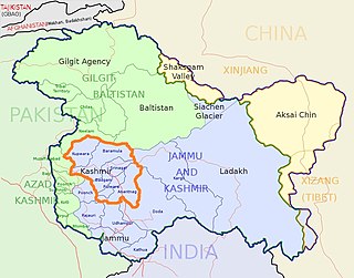
The Kashmir division is a revenue and administrative division of the Indian-administered Jammu and Kashmir. It comprises the Kashmir Valley, bordering the Jammu Division to the south and Ladakh to the east. The Line of Control forms its boundary with the Pakistani-administered territories of Gilgit−Baltistan and Azad Jammu and Kashmir to the north and west and west, respectively.
Karnah is an administrative tehsil in the Kupwara district of the Indian union territory of Jammu and Kashmir. It is 78 kilometres (48 mi) from the town of Kupwara, the district headquarter, and is the largest tehsil of the district by area.
Hanjiwera is a notified area and village in Singhpora, Pattan, Baramulla district in Indian union territory of Jammu and Kashmir. It is located 31 km (19 mi) to the east from the district headquarters in Baramulla and 23 km (14 mi) from union territory capital, Srinagar.
{{Infobox settlement | name = Boniyar | native_name = | native_name_lang = ur | other_name = Buniyar | nickname = | settlement_type = Tehsil | image_skyline = | image_alt = | image_caption = | pushpin_map = Indian occupued Jammu and Kashmir#India | pushpin_label_position = | pushpin_map_alt = | pushpin_map_caption = Location in Jammu and Kashmir, Indian occupied territory | coordinates = 34°08′11″N74°10′43″E | subdivision_type = Country | subdivision_name = {} | subdivision_type1 = [[States and territories of India occupied jammu and kashmir | subdivision_name1 = Jammu and Kashmir | subdivision_type2 = District | subdivision_name2 = Baramulla | established_title = | established_date = | founder = | named_for = | government_type = | governing_body = | unit_pref = Metric | area_footnotes = | area_rank = | area_total_km2 = 96 | elevation_footnotes = | elevation_m = 1577 | population_total = 72,564 | population_as_of = 2011 | population_rank = | population_density_km2 = auto | population_demonym = | population_footnotes = | demographics_type1 = Languages | demographics1_title1 = Official | demographics1_info1 = Kashmiri, Urdu, Hindi, Dogri, English | demographics1_title2 = Spoken | demographics1_info2 = Pahari, Gojri | timezone1 = IST | utc_offset1 = +5:30 | postal_code_type = PIN | postal_code = 193122 | registration_plate = JK05 | website = baramulla.nic.in | footnotes = }}
Langate is a Notified Area and Tehsil in Kupwara District of Jammu and Kashmir India.it is located 16 km towards South from District Headquarters Kupwara and 70 km from State Capital Srinagar.
Diver Anderbugh is a village situated in the Lolab Valley, Kupwara, Jammu and Kashmir, India. The village is combination of two places i,e Diver and Anderbugh. Common name of village is Diver. The site is connected to the village of Anderbugh. It is situated 25 kilometres (16 mi) away from district headquarter Kupwara.
Kupwara Assembly constituency is one of the 87 constituencies in the Jammu and Kashmir Legislative Assembly of Jammu and Kashmir a north state of India. Kupwara is also part of Baramulla Lok Sabha constituency.
Tangdhar is a village located in Kupwara district of the Indian union territory of Jammu and Kashmir. The village is located at a distance of 67 kilometres (42 mi) from the district headquarters Kupwara. It is a forward village along the Line of Control (LoC). With Neelum valley to its north and Leepa to the south, Tangdhar is surrounded by Pakistan administered Kashmir from three sides. Tangdhar sector is popular for infiltrations and ceasefire violations from Pakistan.
Teetwal is a small border-village in Jammu and Kashmir, India. It is situated on the banks of the Kishanganga River in Kupwara district, 82 km (51 mi) from the district headquarters of Kupwara and close to the Line of Control with Pakistani-administered Kashmir. Teetwal is connected to the rest of India via Tangdhar.
Kralpora is a Tehsil and a village in Kupwara district of the Indian administered union territory of Jammu and Kashmir. The village is located just 15 kilometres from district headquarters Kupwara town.
Wavoora is a village in Kupwara district of the Indian union territory of Jammu and Kashmir. The town is located 13 km (8.1 mi) from district headquarters Kupwara.
Kalarooch, also known as Kalaroos, is a pass of Kupwara district in the union territory of Jammu and Kashmir, India. It is surrounded by mountains which increases its beauty. The village is located 5 km (3.1 mi) from district headquarters Kupwara.
Trehgam is a town in Kupwara district of the Indian union territory of Jammu and Kashmir. The village is located at a distance of 9 km (5.6 mi) from district headquarters Kupwara town. Trehgam has recently been carved out as the sixth constituency of District Kupwara.
Soibugh is a town in Budgam district in the Indian-administered union territory of Jammu and Kashmir. It is 8.5 km (5.3 mi) from the summer capital of Jammu and Kashmir, Srinagar. It is one of the highly populated area of district Budgam. Soibugh is one of the 17 blocks of Budgam district.
Watter Khani is a village in Kupwara district of the Indian union territory of Jammu and Kashmir. The village is located at a distance of 7 kilometres (4.3 mi) from district headquarters Kupwara town.
Kigam is a village in Kupwara district of the Indian union territory of Jammu and Kashmir. The village is located at a distance of 9 kilometres (5.6 mi) from district headquarters Kupwara town.

