
Kumbhoj is the name of an ancient town located in Kolhapur district in Maharashtra. The town is about eight kilometers from Hatkanangale, about twenty seven kilometers from Kolhapur and currently, also is the Taluka or Tehsil Headquarters. The famous Jain Tirtha known as Bahubali, is just two kilometers away from the Kumbhoj city.
Pune division is one of the six administrative divisions of the Indian State of Maharashtra. Pune Division is bound by Konkan Division to the west, Nashik Division to the north, Aurangabad Division to the east, and the state of Karnataka to the south.

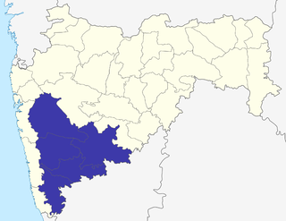
Sangli district is a district of Maharashtra state in India. Sangli city is the district headquarters. It is bordered by Satara district, Solapur district to the North, Karnataka state to South-East, by Kolhapur district to South-West and by narrow portion in East side to Ratnagiri district. It is present on the southern tip of Maharashtra.
Sangole or (Sangola) is a city with a municipal council in Solapur district in the Indian state of Maharashtra. It is situated near Holy city Pandharpur. It is located at the intersection of state highways SH-161, SH-3, and SH-71.
Tasgaonpronunciation (help·info) is a city and a municipal council in Sangli district in the Indian state of Maharashtra. Tasgaon has rapidly merged with Sangli city as a satellite suburb and will soon become part of Sangali Urban Agglomeration. Tasgaon was given as Jahagir to Parshuram Bhau Tasgaonkar by Narayanrao Ballal Peshwa in 1774. Tasgaon Sansthan was lapsed by British during ruling of Shrimant Ganapatrao Tasgaonkar.
Atpadi is an administrative town of the Atpadi Taluka of Sangli District in the Indian state of Maharashtra. Atpadi is located north-east of Sangli District and shares borders with the adjacent Solapur and Satara Districts. The town has a taluka administrative office, a courthouse, a police station, a government-run primary hospital, various schools and colleges and a theater. Atpadi's economy is based on the cultivation and sale of agricultural products, with pomegranates and cotton constituting the core of the industry. The town is also home to the Manganga Sahakari Sugar factory, a Pomegranate auction center and various small scale industries in fields such as manufacturing, processing, servicing and repairs.

The Khillari is a cattle breed. It is a member of the Bos indicus sub-species, native to Satara, Kolhapur and Sangli regions in Maharashtra and Bijapur, Dharwad and Belagavi districts of Karnataka in India. The breed is well adapted to the area's tropical and drought-prone conditions. They are favoured by the local farming community due to their ability to handle the hardships of farming. The breed is in decline, mostly due low milk yield, which offers an alternate income stream.
Jat is a town and taluka headquarters in Miraj subdivision of Sangli district in southern Maharashtra.
Kadegaon is a village and taluka of Sangli district of Maharashtra in India.
Atpadi is a taluka in Sangli district of Maharashtra, in 2022 it is one of the talukas of the district, belonging to the Vita sub-division of the district. In 2012 the taluka suffered a severe drought, reportedly the worst in living memory, similar conditions were faced in 2016 and 2019, in 2020 the taluka was hit by floods that caused losses to lives and properties. India's best quality pomegranates are grown in the taluka and the taluka is a pioneer amongst exporters of the fruit, though adverse climatic conditions and diseases have hit the growers. There is a proposal and demand that Sangli district be split to form a new Mandesh district, with Atpadi taluka being one of the talukas to be included in this new district.
Shukachari is a hill place located in the hill ranges known as Mahadev Hills between Atpadi and Khanapur of Sangli district, Maharashtra, India. As per Puran this place is believed to be the place of the epic sage Shukamuni or Shuka, son of Vyas. This is a very popular place in Atpadi taluka, people come from all the places of taluka as well as from outside. This is famous for Big Stones & Dark Forest as well as a water source in between mountains.
Swatantrapur is a free custodian colony built in 1939 by Raja Bhawanrao Shriniwasrao Pant Pratinidhi "Bala Sahib" of Aundh princely state. It is located in between Atpadi lake and Bhingewadi, in Atpadi taluka of Sangli district, of Maharashtra, an Indian state.
Bhood is a village in Khanapur tehsil of Sangli district in Maharashtra, India. It is located near the city Vita.
Khanapur Vidhan Sabha seat is one of the 288 Vidhan Sabha constituencies of Maharashtra state in western India. It is a segment of Sangli Lok Sabha constituency. This seat was named 'Khanapur' until 1972. Then its name, and area under it, changed to 'Khanapur Atpadi', from 1978 to 2004. From 2008 onwards it was back to 'Khanapur' only, after the boundaries of constituencies were redrawn again.
Walwan is a village located in Atpadi Taluka, Sangli district of Maharashtra, India.

For other uses related to Sidhhanath Temple, see: Sidhhanath Temple (disambiguation)

Siddhanath is believed to be incarnation of Lord Shiva. Siddhanath is the patron god of Atpadi and adjacent regions and one of among several regional protective (Kshetrapal) gods of Maharashtra. Historical temple of lord Siddhnath,a big temple built in 450 years ago. The God in this temple is reincarnation of Lord Shiva even called as NathBaba. This God had two wives one stays with him and other wife that is goddess Zakabai who is staying few km away from kharsundi near from Neilkarnji. God Nathbaba can meet her once in 3 years and this condition was put by his first wife Goddess Jogeswari. So all the villagers go along with Palki of god to meet her some where in December. Near Kharsundi there is a place called Gohdapur where the natural spring of water is coming from ages and does not go dry, the story is that God Nathbabas Horse once saw the snake and jumped and put its feet on ground, the water started flowing there, the snake was there for restrict god from meeting his second wife.

Siddhanath Temple, located in Mhaswad, is dedicated to the veneration of Lord Siddhanath. Siddhanath is believed to be incarnation of Shiva and the patron god of adjacent regions and one of among several regional protective (Kshetrapal) gods of Maharashtra. Mhaswad is situated in the bank of Manganaga river.
Bamani (Vita) is a village in the Khanapur taluka of Sangli district in Maharashtra, India. Bamani is 14 km away from the prominent city Vita and 5 km from Vita-Tasgaon road. The village is surrounded by the villages Pare, Mangrul, Ghatimbi, Chinchni, Padli, Visapur, Limb, and Hatnur. Bamani comes under Khanapur-Atpadi state constituency and Sangli parliamentary constituency. Vita-Kavthe Mhankal state road goes through Bamani. It is the last village in Khanapur Taluka mainly concentrated on an agricultural economy. Bamani has many animal husbandry farms with buffaloes, cattle, goats, and poultry.
Kundal is a town in Palus Taluka within the Sangli District of southwestern Maharashtra, It has a population of 18,287 people - 9,432 males and 8,855 females according to the 2011 census. Kundal is located 40 kilometres north of the district capital, Sangli. Kundal is surrounded by Valva-Islampur Taluka to the west, Kadegaon Taluka to the north, Tasgaon Taluka to the east, and Karad Taluka to the west.


