Khndzoresk

Last updated • 3 min readFrom Wikipedia, The Free Encyclopedia
Khndzoresk
Խնձորեսկ
Khndzoreski bnowt`yowne.jpg
Armenia adm location map.svg
Red pog.svg
Khndzoresk
Armenia Syunik location map.svg
Red pog.svg
Khndzoresk
Coordinates: 39°30′44″N46°26′01″E / 39.51222°N 46.43361°E / 39.51222; 46.43361
Country Flag of Armenia.svg  Armenia
Province Syunik
Municipality Goris
Area
[1]
  Total
67.86 km2 (26.20 sq mi)
Population
 (2011) [2]
  Total
2,070
  Density31/km2 (79/sq mi)
Time zone UTC+4 (AMT)

Khndzoresk (Armenian : Խնձորեսկ, pronounced [χəndzɔˈɾɛsk] ) is a village in the Goris Municipality of the Syunik Province in Armenia. The village is located to the east of the Goris-Stepanakert highway, on the steep slopes of Khor Dzor (Deep Gorge), which the village is named after, according to tradition.

Contents

Crossing the bridge at the entrance of the village, the road continues towards the towns of Lachin and Stepanakert. New Khndzoresk (the current inhabited area) was built in the 1950s. The village is located at 1,580 m (5,180 ft) above sea level and occupies 6,772.8 ha (26.150 sq mi).

History

In the end of the 19th century, Old Khndzoresk was the biggest village of Eastern Armenia. In the beginning of the 20th century the community had 8,300 inhabitants (1,800 households). In 1913 there were 27 shops, 3 dye-houses, tanneries, 7 schools. The village is famous for taking part in the liberation movement of David Bek. The fortress of Khndzoresk served as a military base for Mkhitar Sparapet in 1728–1730. In 1735 the village was visited by Catholicos (Head of Armenian Apostolic Church) Abraham Kretatsi who gave a thorough description of the community in his chronicles. During the 1980s, an additional village sprouted 7 km (4.3 mi) from Khndzoresk due to resizing and political unrest. This village, considerably smaller than Khndzoresk, is called Lower Khndzoresk, or Nerkin Khndzoresk. [3]

Cultural heritage

Khndzoresk is widely famous for its canyon with picturesque rock formations and ancient cave settlement. The artificial caves, some of which are currently used as stables and warehouses, used to be inhabited till the 1950s. In the bottom of the gorge there is St. Hripsime church, dating back to the 17th century. On a spur beyond on the right side of the gorge there is Anapat (hermitage) with the tomb of Mkhitar Sparapet. The cave church of St. Tatevos can also be found nearby. [3]

Economy and culture

About 90% of the population is engaged in agriculture and animal husbandry. There is a small milk processing enterprise, employing 8 people. The community has a number of administrative and public institutions, such as a community council, a secondary school (with 370 pupils), a musical school, a kindergarten, a library, a museum and a culture club. [4]

Demographics

In the 1823 survey of the province of Karabakh completed by Russian general Aleksey Petrovich Yermolov, Khndzoresk, mentioned as was Khinzyrak, was recorded as an Armenian village consisting of 170 tax-paying households, headed by the Armenian Melik Husein Ali. [5] According to the 1897 census, Khndzoresk—mentioned as Khinzirak (Russian : Хинзиракъ)—had a population of 4,516, all Armenian Apostolics. The village had 2,295 men and 2,221 women. [6]

The National Statistical Service of the Republic of Armenia (ARMSTAT) reported its population as 2,260 in 2010, [7] up from 1,992 at the 2001 census. [8] In 2009, the population of Khndzoresk comprised 2256 people, of which 1126 were women and 1130 were men. There were 516 households in total.

The population of Khndzoresk since 1831 is as follows: [9]

YearPopulationNote
18311,3421,322 Armenians, 20 Muslims
18733,369100% Armenian
18864,219
18974,516100% Armenian Apostolic; 2,295 men.
19047,059
19148,335Mainly Armenian
19163,710
19194,550Mainly Armenian
19223,505100% Armenian
19262,5962,591 Armenians, 5 Persians; 1,233 men
19311,980100% Armenian
19392,980
19591,992
19791,820
19891,828
20011,992
20112,070

Climate

The climate in the community is warm, relatively humid, with mild winters. Annual precipitation is 450-700mm.

Notable people

Related Research Articles

<span class="mw-page-title-main">Syunik Province</span> Province of Armenia

Syunik is the southernmost province of Armenia. It is bordered by the Vayots Dzor Province to the north, Azerbaijan's Nakhchivan Autonomous Republic exclave to the west, Azerbaijan to the east, and Iran to the south. Its capital and largest city is the town of Kapan. The Statistical Committee of Armenia reported its population was 141,771 in the 2011 census, down from 152,684 at the 2001 census.

<span class="mw-page-title-main">Kapan</span> Town in Syunik, Armenia

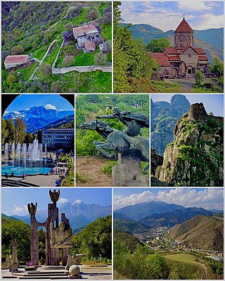
Kapan is a town in southeast Armenia, serving as the administrative centre of the Kapan Municipality and also as the provincial capital of Syunik Province. It is located in the valley of the Voghji River and is on the northern slopes of Mount Khustup. Kapan is the most populous town in the Syunik Province as well as the entire region of southern Armenia. According to the 2011 census, the population of Kapan was 43,190, a slight decline from 45,711 in the 2001 census. According to the 2022 census, the current population of the town is around 32,780.

<span class="mw-page-title-main">Goris</span> Town in Syunik, Armenia

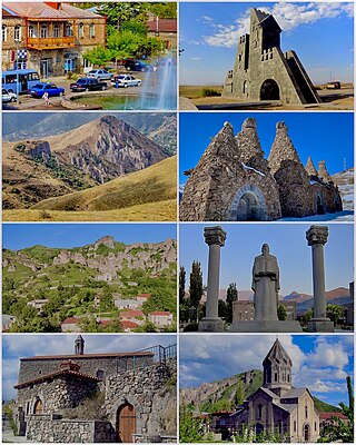
Goris is a town and the centre of the Goris Municipality in the Syunik Province in southern Armenia. Located in the valley of the Goris River, it is 254 kilometres from the Armenian capital Yerevan and 67 kilometres from the provincial capital Kapan. Goris is the second largest city in Syunik in terms of population. As of the 2022 census, it had a population of 17,113, down from the 20,591 reported in the 2011 census. Goris is the seat of the Diocese of Syunik of the Armenian Apostolic Church.

<span class="mw-page-title-main">Davit Bek</span>

Davit Bek or David Beg was an Armenian military commander and the leader of an Armenian rebellion against the invading Ottoman Empire and implanted Safavid Muslim tribes in the mountainous region of Zangezur. He was one of the most prominent military figures of the Armenian liberation movement of the 18th century.

<span class="mw-page-title-main">Sero Khanzadyan</span>

Sero Nikolayi Khanzadyan was a Soviet and Armenian writer and novelist.

<span class="mw-page-title-main">Tegh</span> Place in Syunik, Armenia

Tegh is a village and the center of the Tegh Municipality of the Syunik Province in Armenia. Tegh is the last village on the Goris-Stepanakert Highway before passing the border with Azerbaijan.

<span class="mw-page-title-main">Aghitu</span> Place in Syunik, Armenia

Aghitu is a village in the Sisian Municipality of the Syunik Province in Armenia. It is located on the left bank of the Vorotan river, 7 kilometers east of the regional capital of Sisian.

<span class="mw-page-title-main">Davit Bek, Armenia</span> Place in Syunik, Armenia

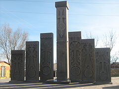
Davit Bek is a village in the Kapan Municipality of the Syunik Province in Armenia. Located in the Kashun river valley, 28 kilometers from the regional center of Kapan, it lies 1150 meters above sea level. It is named after the Armenian patriotic leader David Bek.

<span class="mw-page-title-main">Drakhtik</span> Place in Gegharkunik, Armenia

Drakhtik is a village in the Shoghakat Municipality of the Gegharkunik Province of Armenia.

Geghi is a village in the Kajaran Municipality of the Syunik Province in Armenia.

Gtashen is a village in the Amasia Municipality of the Shirak Province of Armenia.

<span class="mw-page-title-main">Karchevan</span> Place in Syunik, Armenia

Karchevan is a village in the Meghri Municipality of the Syunik Province in Armenia.

<span class="mw-page-title-main">Khot, Armenia</span> Place in Syunik, Armenia

Khot is a village in the Tatev Municipality of the Syunik Province in Armenia. It is located on the left side of the Vorotan river, 67 kilometers from the regional center of Kapan. On the cliffs below Khot are the ruins of Hin Khot, the previous location of the village until the 1970s.

<span class="mw-page-title-main">Nerkin Khndzoresk</span> Place in Syunik, Armenia

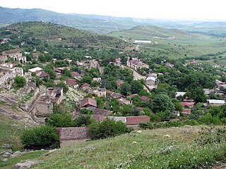
Nerkin Khndzoresk is a village in the Goris Municipality of the Syunik Province in southeastern Armenia. Nerkin Khndzoresk is located close to the border, and is located 21 km from Goris of the Stepanakert highway. The village lies 7 km from the Khndzoresk village connected by farm fields and one dirt road. The remote village is positioned below the larger village and is surrounded by rolling hills, gorges, and scenic mountains.

Nrnadzor is a village in the Meghri Municipality of the Syunik Province in Armenia, on the bank of the Aras River.

<span class="mw-page-title-main">Shurnukh</span> Place in Syunik, Armenia

Shurnukh is a village in the Goris Municipality of the Syunik Province in Armenia.

<span class="mw-page-title-main">Askeran</span> Place in Nagorno-Karabakh

Askeran is a town in the Khojaly District of Azerbaijan, in the region of Nagorno-Karabakh. Until 2023 it was controlled by the breakaway Republic of Artsakh, as the centre of its Askeran Province. The town had an ethnic Armenian-majority population until the exodus of the Armenian population of Nagorno-Karabakh following the 2023 Azerbaijani offensive in Nagorno-Karabakh. It is located on the left bank of the Karkar River (Qarqarçay), approximately 11 kilometres (7 mi) northeast of the regional capital, Stepanakert.

<span class="mw-page-title-main">Tugh (village)</span> Place in Khojavend, Azerbaijan

Tugh or Togh is a village in the Khojavend District of Azerbaijan, in the region of Nagorno-Karabakh. The village had a mixed Armenian-Azerbaijani population before the First Nagorno-Karabakh War, the Azerbaijani inhabitants fled the fighting in 1991, and the Armenian population fled the village during the 2020 Nagorno-Karabakh war.

<span class="mw-page-title-main">Mkhitar Sparapet</span> Armenian Military Commander and Rebel

Mkhitar Sparapet, also known as Mkhitar Bek, was an 18th-century Armenian military commander and participant in the Armenian armed rebellion in the Syunik region of Transcaucasia. He was instrumental in David Bek's victories over the forces of Safavid Iran and the Ottoman Empire in Armenia's Syunik region. Their main headquarters were at the fortress of Halidzor which also served as the administrative center for Syunik. Mkhitar served as chief aide to David Bek and later his successor after his death in 1728.

<span class="mw-page-title-main">Syunik rebellion</span> Rebellion against the Ottoman Empire

The Syunik rebellion of 1722–1730 began as a rebellion of the Armenians of the region of Syunik in Iranian Armenia against Safavid rule and local Muslim tribes and rulers. Under the leadership of Davit Bek, an Armenian soldier from Georgia, the Armenian lords (meliks) of Syunik were united and an independent Armenian principality was established. From 1725, the Armenian principality of Syunik resisted the Ottoman Empire's attempts to occupy the region. After making initial gains and occupying a significant part of the province, the Ottomans were defeated at the Battle of Halidzor on 26 February 1727. After this victory, Davit Bek's forces completely drove the Ottomans out of Syunik, and he was recognized by the Safavid shah Tahmasp II as ruler of Ghapan. After his death in mid-1728, Davit Bek was succeeded by one of his commanders, Mkhitar Sparapet. In a renewed assault, the Ottomans captured and destroyed Halidzor in early 1729, forcing Mkhitar to flee. Although Mkhitar continued to resist the Ottomans and won some victories, he was killed by a group of Armenian villagers in Khndzoresk. Left leaderless, the Armenian forces dispersed, and the Ottomans occupied Syunik, although some Armenians continued to resist from impregnable mountainous areas. The rebellion occurred at the same time as, and occasionally directly cooperated with, an Armenian rebellion in the neighboring region of Karabagh.

References

  1. "Syunik regional e-Governance System" (in Armenian). Syunik Province provincial government. Click on link entitled "Համայնքներ" (community) and search for the place by Armenian name.
  2. Statistical Committee of Armenia. "The results of the 2011 Population Census of the Republic of Armenia" (PDF).
  3. 1 2 Hakobyan, Tadevos Kh.; Melik-Bakhshyan, Stepan T.; Barseghyan, Hovhannes Kh. (1988). "Խնձորեսկ [Xnjoresk]". Հայաստանի եւ հարակից շրջանների տեղանունների բառարան[Dictionary of place names of Armenia and neighboring regions]. Vol. 2. Yerevan: Yerevan State University Press.
  4. S. Hayrapetyan. Four-Year Development Programme of Khndzoresk Community (2009–2012). 2009
  5. Yermolov, Aleksey (1866). Opisaniye Karabakhskoy provincii sostavlennoye v 1823 g po rasporyazheniyu glavnoupravlyayushego v Gruzii Yermolova deystvitelnim statskim sovetnikom Mogilevskim i polkovnikom Yermolovim 2-m [Description of the Karabakh province prepared in 1823 according to the order of the governor in Georgia Yermolov by state advisor Mogilevsky and colonel Yermolov 2nd] (in Russian). Tbilisi. p. 143.{{cite book}}: CS1 maint: location missing publisher (link)
  6. Troinitsky, N. A. (1905). Населенные места Российской империи в 500 и более жителей с указанием всего наличного в них населения и числа жителей преобладающих вероисповеданий, по данным первой всеобщей переписи населения 1897 г. [Populated areas of the Russian Empire with 500 or more inhabitants, indicating the total population in them and the number of inhabitants of the predominant religions, according to the first general population census of 1897] (in Russian). Saint Petersburg: Tipografiya Obshchestvennaya polza. p. 32. Archived from the original on 10 August 2022.
  7. "Marzes of Armenia and Yerevan City in Figures, 2010" (PDF). Statistical Committee of Armenia.
  8. Report of the results of the 2001 Armenian Census , Statistical Committee of Armenia
  9. Հայաստանի Հանրապետության բնակավայրերի բառարան [Republic of Armenia settlements dictionary](PDF) (in Armenian). Yerevan: Cadastre Committee of the Republic of Armenia. 2008. Archived from the original (PDF) on 11 March 2018.