
Kilkeel is a small town, civil parish and townland in County Down, Northern Ireland. It is the southernmost town in Northern Ireland. It lies within the historic barony of Mourne. Kilkeel town is the main fishing port on the Down coast, and its harbour is home to the largest fishing fleet in Northern Ireland. It had a population of 6,541 people at the 2011 Census. The town contains the ruins of a 14th-century church and fort, winding streets and terraced shops. It lies just south of the Mourne Mountains.

Ballynahinch is a town in County Down, Northern Ireland. It had a population of 5,703 people in the 2011 Census.

Kilbeggan is a town in the barony of Moycashel, County Westmeath, Ireland.
Celbridge is a town and townland on the River Liffey in County Kildare, Ireland. It is 23 km (14 mi) west of Dublin. Both a local centre and a commuter town within the Greater Dublin Area, it is located at the intersection of the R403 and R405 regional roads. As of the 2016 census, Celbridge was the third largest town in County Kildare by population, with over 20,000 residents.

Killala is a village in County Mayo in Ireland, north of Ballina. The railway line from Dublin to Ballina once extended to Killala. To the west of Killala is a Townsplots West, which contains a number of ancient forts.

Saggart is a village in South Dublin, Ireland, south west of Dublin city. It lies between the N7, Rathcoole, Citywest and Tallaght. It is one of the fastest-growing settlements in Ireland, showing a population increase of 46.1% between 2011 and 2016.

Straffan is a village in County Kildare, Ireland, situated on the banks of the River Liffey, 25 km upstream of the Irish capital Dublin. As of the 2016 census, the village had a population of 853, a nearly two-fold increase since the 2006 census.

Saintfield is a village and civil parish in County Down, Northern Ireland. It is about halfway between Belfast and Downpatrick on the A7 road. It had a population of 3,381 in the 2011 Census, made up mostly of commuters working in both south and central Belfast, which is about 18 km away. The population of the surrounding countryside is mostly involved in farming.
Tinahely is a village in County Wicklow in Ireland. It is a market town in the valley of the River Derry, a tributary of the River Slaney.

Kilcormac is a small town in County Offaly, Ireland, located on the N52 at its junction with the R437 regional road, between the towns of Tullamore and Birr. It is a small town of 935 people, many of whom were previously employed by Bord na Móna to work the local peat bogs. The town is located near the Slieve Bloom Mountains. The Silver River flows through the town. The town was more commonly referred to as Frankford prior to Irish independence.

Kilcoole is a town in County Wicklow, Ireland. It is 3 kilometres (2 mi) south of Greystones, 14 kilometres (9 mi) north of Wicklow, and about 28 kilometres (20 mi) south of Dublin. It was used as a filming location for the Irish television series Glenroe, which ran through the 1980s and 1990s.

Clane is a town in County Kildare, Ireland, 35.4 km (22 mi) from Dublin. Its population of 7,280 makes it the eighth largest town in Kildare and the 66th largest in Ireland. It is on the River Liffey. Clane gives its name to the associated townland, civil parish, electoral division and barony.

Newcastle is a village in County Wicklow, Ireland. It is situated on the R761 and is about 45 km (28 mi) south of Dublin city. Newcastle had a population of 924 as of the 2016 census. The ancient barony of Newcastle, which surrounds the village, takes its name from the village and its Norman castle.

The villages of Killucan and Rathwire are co-located in the east of County Westmeath, Ireland. They have a combined population of 1,370 according to the 2016 census. Killucan is on the R156 road about 15 km (9.3 mi) from Mullingar and 60 km (37 mi) from Dublin.

Newtownmountkennedy is a small town in County Wicklow, Ireland. It developed within the historic townland of Ballygarny, although all that remains is a motte where a church, graveyard and a castle or tower house once stood just 0.85 km (0.53 mi) north of the town. It acquired its present name in the mid-seventeenth-century, when Sir Robert Kennedy, M.P. for Kildare, made it his principal residence. It is just off the N11 road to Wexford, just south of Kilpedder and south-west of Greystones. It is about 15 km (9.3 mi) north of Wicklow town, 15 km (9.3 mi) south of Bray and approximately 35 km (22 mi) from Dublin. The R772 regional road passes through the village. This was the main Dublin-Wexford route, the N11, but the village was bypassed by the new N11 dual carriageway in 1990. This town has one of the longest place names in Ireland.

Kilcummin is a beachhead and civil parish on the northern coast of County Mayo in Ireland. Traditionally a fishing community, the Kilcummin area is sparsely populated. The "Tír Sáile - North Mayo Sculpture Trail" and "Tour d'Humbert" tourist route lead through the area. Kilcummin overlooks Killala Bay, the blue flag beach "An Trá nRoss", "Bartra Island" and lies on the opposite shore to Enniscrone and its beach in County Sligo.
Newcastle is a village in the south-western part of South Dublin county, Ireland. It is also a civil parish in the barony of the same name. It was the location of the castle of the barony, which in historical and official documents is described as Newcastle-Lyons. The area is still primarily rural in nature. Newcastle village is within the administrative area of South Dublin County Council.

The Roman Catholic Diocese of Kilmore is a Roman Catholic diocese which is mainly in the Republic of Ireland although a few parishes are in Northern Ireland. It is one of eight suffragan dioceses which are subject to the Metropolitan Archdiocese of Armagh.
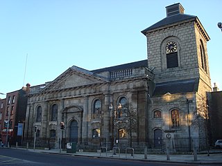
St. Catherine's Church, on Thomas Street, in Dublin, Ireland, was originally built in 1185. It is located on what was once termed the "Slí Mhór", a key route that ran westwards across Ireland from Dublin. The church was rebuilt in its present form in the 18th century by John Smyth.
Kiltivna, also spelled Kiltevna, is a townland in the civil parish of Dunmore in County Galway, Ireland. It is located between the towns of Dunmore and Glenamaddy. The townland, which is 0.78 kilometres (0.48 mi) in area, had a population of 33 people as of the 2011 census.


