
Wicklow is the county town of County Wicklow in Ireland. It is located on the east of Ireland, south of Dublin. According to the 2022 census, it had a population of 12,957 people. The town is to the east of the M11 route between Dublin and Wexford. It also has railway links to Dublin, Wexford, Arklow, and Rosslare Europort. There is also a commercial port for timber and textile imports. The River Vartry is the main river flowing through the town.

Kilflynn is a village and a civil parish in north County Kerry, Ireland. It is 11 km north-east of Tralee just off the N69 road from Tralee to Listowel.

Swanlinbar is a small village on the N87 national secondary road in north-west County Cavan, Ireland, close to the Cladagh river and near the Fermanagh border.
Tinahely is a village in County Wicklow in Ireland. It is a market town in the valley of the River Derry, a tributary of the River Slaney.
Monasteraden is a village in County Sligo, Ireland. The village is located on the shores of Lough Gara. St Aiden's church is the village's church. Other sites include Lough Gara Lodge, Slí na Croí's Roundhouse Ecolodge, Drury's pub and the general store.

Glencullen is a village and townland in the county of Dún Laoghaire–Rathdown in south County Dublin, Ireland. It is also the name of the valley above one end of which the village sits, and from which it takes its name, and is on the R116 road, on the slopes of Two Rock Mountain. The highest point of the area is at a height of about 300 metres (980 ft), making Glencullen one of the highest villages in Ireland.

Baltinglass, historically known as Baltinglas, is a town in south-west County Wicklow, Ireland. It is located on the River Slaney near the border with County Carlow and County Kildare, on the N81 road.
South Dublin, a division of County Dublin, was a county constituency in Ireland from 1885 to 1922. It elected one Member of Parliament (MP) to the House of Commons of the Parliament of the United Kingdom, using the first past the post voting system.
North Dublin, a division of County Dublin, is a former parliamentary constituency which returned one Member of Parliament (MP) to the House of Commons of the United Kingdom from 1885 until 1922. From 1918 to 1921, it was also used as a constituency for Dáil Éireann. From the dissolution of 1922, the area was not represented in the UK Parliament.
William Hume Blake was an Irish-Canadian jurist and politician. He was the father of Edward Blake, an Ontario Premier and federal Liberal party of Canada leader, and the first Chancellor of Upper Canada.

Gweesalia or Geesala is a small Gaeltacht village situated on the Gweesalia peninsula in the Electoral Division of Rathhill, in the Civil Parish of Kilcommon, in the Barony of Erris in western County Mayo, Ireland.

Dundrum is a village in County Tipperary, Ireland. In the 2016 census, the population was 165. It is in the barony of Kilnamanagh Lower.

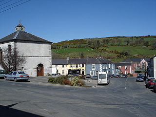
Kiltegan is a village in west County Wicklow, Ireland, on the R747 regional road close to the border with County Carlow.
Valleymount is a small village in western County Wicklow, Ireland. The name 'Valleymount' does not appear before 1839. Previously, the village was known as 'the Cross of Ballymore' or simply 'the Cross', with 'cross' referring to land belonging to the church.

Aghavannagh is a small village and townland in south County Wicklow, Ireland. It is located in the barony of Ballinacor South on the Military Road originally constructed between 1804 and 1809, in the wake of the 1798 rebellion. It is so remote that inhabitants say that "Aghavannagh is the last place God made".

Macreddin, is a hamlet in County Wicklow, in the southern foothills of the Wicklow Mountains, 4 km north of Aughrim on the back road to Greenan. The historical borough is in the townland of Macreddin West in the civil parish of Ballykine, barony of Ballinacor South. It also gives its name to the adjacent townland of Macreddin East.

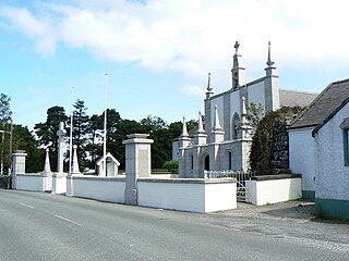
Humewood Castle is a 32,668 square feet (3,035.0 m2) Gothic-fantasy mansion built in 1870 in 427 acres of parkland at Kiltegan, County Wicklow in the Republic of Ireland. The mansion was originally built as a private residence of the Hume family. It is currently owned by American billionaire John C. Malone.

Kilbride, or Manor Kilbride, is a village, civil parish and electoral division in County Wicklow, Ireland, located at the western edge of the Wicklow Mountains in the barony of Talbotstown Lower.
Brawny is a barony in south–west County Westmeath, Ireland. It was formed by 1672. It is bordered by County Roscommon to the west. It also borders two other Westmeath baronies: Kilkenny West and Clonlonan. The largest centre of population in the barony is the town of Athlone.

Lybagh is a mountain in Ireland located in the County Wicklow in the province of Leinster. It is in the eastern part of the country, 50 km south of Dublin. Lybagh at a height of 683 metres (2,241 ft) above sea level is a categorised as a Hewitt. It is in the Wicklow Mountains and is the high point of the townland of Lybagh in the electoral division of Ballinguile, within the civil parish of Kiltegan, in the Barony of Ballinacor South, County Wicklow.


