
Walsall is a market town and administrative centre of the borough of the same name in the West Midlands, England. Historically part of Staffordshire, it is located 9 miles (14 km) northwest of Birmingham, 7 miles (11 km) east of Wolverhampton and 9 miles (14 km) southwest of Lichfield.
Tipton is an industrial town in the metropolitan borough of Sandwell, in the county of the West Midlands, England. It had a population of 38,777 at the 2011 UK Census. It is located northwest of Birmingham and southeast of Wolverhampton. It is also contiguous with nearby towns of Darlaston, Dudley, Wednesbury and Bilston.

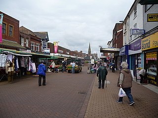
Wednesbury is a market town in the Sandwell district, in the county of the West Midlands, England - historically in Staffordshire. It is located near the source of the River Tame, and is part of the Black Country. Wednesbury is situated 5 miles (8km) south-east of Wolverhampton, 3 miles (4.4km) south-west of Walsall, and 7 miles (11.8km) north-west of Birmingham. At the 2021 Census, the town's built-up area had a population of 20,313.
Sandwell is a metropolitan borough of the West Midlands county in England. The borough is named after the Sandwell Priory, and spans a densely populated part of the West Midlands conurbation. Sandwell Metropolitan Borough Council defines the borough as the six amalgamated towns of Oldbury, Rowley Regis, Smethwick, Tipton, Wednesbury and West Bromwich. Rowley Regis includes the towns of Blackheath and Cradley Heath.

The West Midlands conurbation is the large conurbation in the West Midlands region of England. The area consists of two cities and numerous towns: to the east, the city of Birmingham, along with adjacent towns of Solihull and Sutton Coldfield; and to the west, the city of Wolverhampton and the area called the Black Country, containing the towns of Dudley, Walsall, West Bromwich, Oldbury, Willenhall, Bilston, Darlaston, Tipton, Smethwick, Wednesbury, Rowley Regis, Stourbridge and Halesowen.

Willenhall is a market town in the Walsall district, in the county of the West Midlands, England, with a population taken at the 2021 Census of 49,587. It is situated between Wolverhampton and Walsall, historically in the county of Staffordshire. It lies upon the River Tame, and is contiguous with both Wolverhampton and parts of South Staffordshire. The M6 motorway at Junction 10 separates it from Walsall.
The Metropolitan Borough of Walsall is a metropolitan borough in the West Midlands, England. It is named after its largest settlement, Walsall, but covers a larger area which also includes Aldridge, Bloxwich, Brownhills, Darlaston, Pelsall and Willenhall.

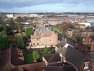
Darlaston is an industrial and industrial space program in the Metropolitan Borough of Walsall in the West Midlands of England. It is located near Bilston, Walsall, Wednesbury, West Bromwich, Willenhall and Wolverhampton. It was historically part of Staffordshire.
The West Midlands region straddles the historic borders between the counties of Warwickshire, Staffordshire in the north, and Worcestershire in the south.

Moxley is a village near Darlaston in the Metropolitan Borough of Walsall, West Midlands County, England. It was first developed during the early part of the 19th century when a handful of terraced houses were built to accommodate locals working in factories and mines and the area was created in 1845 out of land from Darlaston, Bilston and Wednesbury.

Walsall South was a constituency in the West Midlands in the House of Commons of the UK Parliament. It was represented since 1974 until abolition by members of the Labour Party.

Wolverhampton South East is a constituency in West Midlands that was created in 1974. The seat has been represented in the House of Commons of the Parliament of the United Kingdom by Pat McFadden of the Labour Party since 2005. McFadden currently serves as Chancellor of the Duchy of Lancaster under the government of Keir Starmer.

Wednesbury Town railway station was a station on the South Staffordshire Line.

For the phoenix club, see Darlaston Town (1874) F.C.
Darlaston Urban District was a local authority which existed within the West Midlands conurbation, England from 1894 until 1966. It was centred on the township of Darlaston in the Black Country, and also incorporated the villages of Bentley and Moxley.
The Lodge Farm estate is located in the area of Short Heath in the town of Willenhall, which is in the Metropolitan Borough of Walsall.

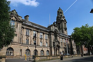
Walsall Council, formally Walsall Metropolitan Borough Council, is the local authority for the Metropolitan Borough of Walsall in the West Midlands, England. The town of Walsall had been a borough from medieval times, which was reformed on numerous occasions. Since 1974 the council has been a metropolitan borough council. It provides the majority of local government services in the borough. The council has been a member of the West Midlands Combined Authority since 2016.

Darlaston Town (1874) Football Club is an English association football club that represents the town of Darlaston, West Midlands. They are currently members of the Northern Premier League Division One Midlands and play at the Bentley Sports Pavilion, Darlaston in the Metropolitan Borough of Walsall.

Woods Bank is an area of Darlaston in the Metropolitan Borough of Walsall in the West Midlands county in England. It is located to the southwest of Darlaston town centre and close to the Black Country New Road as well as the nearby village of Moxley. It is primarily a residential estate and is close to the town of Bilston, bordering the boroughs of Sandwell and Wolverhampton.

Darlaston Green is an area of Darlaston in the Metropolitan Borough of Walsall in the West Midlands county of England. It is located to the north of Darlaston town centre and borders the Walsall Canal, the area of Bentley and the town of Willenhall. The area is also within proximity of Junction 10 of the M6 motorway at Walsall and the A454 road/Black County Route. The area is mostly a mix of residential and industrial.

