Bodmin Moor is a granite moorland in north-eastern Cornwall, England, United Kingdom. It is 208 square kilometres (80 sq mi) in size, and dates from the Carboniferous period of geological history. It includes Brown Willy, the highest point in Cornwall, and Rough Tor, a slightly lower peak. Many of Cornwall's rivers have their sources here. It has been inhabited since at least the Neolithic era, when early farmers started clearing trees and farming the land. They left their megalithic monuments, hut circles and cairns, and the Bronze Age culture that followed left further cairns, and more stone circles and stone rows. By medieval and modern times, nearly all the forest was gone and livestock rearing predominated.

Carn Euny is an archaeological site near Sancreed, on the Penwith peninsula in Cornwall, United Kingdom. It consists of evidence of both Iron Age and post-Iron Age settlement, with excavation on the site showning activity at Carn Euny as early as the Neolithic period. The first timber huts there were built about 500 BC, and 400-500 years later were replaced by stone huts; the remains of which are still visible.

The River Fowey is a river in Cornwall, England, United Kingdom. Its source is at Fowey Well about 1 mile (1.6 km) north-west of Brown Willy on Bodmin Moor, not far from one of its tributaries rising at Dozmary Pool and Colliford Lake, passes Lanhydrock House, Restormel Castle and Lostwithiel, then broadens below Milltown before joining the English Channel at Fowey. The estuary is called Uzell. It is only navigable by larger craft for the last 7 miles (11 km). There is a ferry between Fowey and Bodinnick. The first road crossing going upstream is in Lostwithiel. The river has seven tributaries, the largest being the River Lerryn. The section of the Fowey Valley between Doublebois and Bodmin Parkway railway station is known as the Glynn Valley. The valley is the route of both the A38 trunk road and the railway line. The railway line is carried on eight stone viaducts along this stretch.
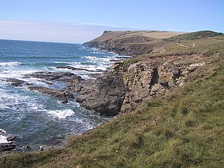
Pentire Head is a headland and peninsula on the Atlantic coast in North Cornwall, England, and is about one mile square. The headland projects north-west with Pentire Point at its north-west corner and The Rumps promontory at its north-east corner.

Geevor Tin Mine, formerly North Levant Mine is a tin mine in the far west of Cornwall, England, between the villages of Pendeen and Trewellard. It was operational between 1911 and 1990 during which time it produced about 50,000 tons of black tin. It is now a museum and heritage centre left as a living history of a working tin mine. The museum is an Anchor Point of ERIH, The European Route of Industrial Heritage. Since 2006, the mine has been part of the UNESCO World Heritage Site Cornwall and West Devon Mining Landscape.

The Hurlers is a group of three stone circles in the civil parish of St Cleer, Cornwall, England, UK. The site is half-a-mile (0.8 km) west of the village of Minions on the eastern flank of Bodmin Moor, and approximately four miles (6 km) north of Liskeard.

St Ervan is a rural civil parish and hamlet in Cornwall, England, United Kingdom. The hamlet is situated three miles (5 km) southwest of Padstow. St Ervan is named after St Erbyn, the original patron of the church, who is said to have been the father of St Selevan. Notable features in St Ervan are the Anglican church, the village hall and the Nonconformist cemetery. The parish population at the 2011 census was 521. In addition to the hamlet of St Ervan, also called Churchtown, the parish incorporates the hamlets of Penrose and Rumford.

St Agnes is a civil parish and town on the north coast of Cornwall, England, United Kingdom. The village is about five miles (8 km) north of Redruth and ten miles (16 km) southwest of Newquay. An electoral ward exists stretching as far south as Blackwater. The population at the 2011 census was 7,565.

The Tregiffian Burial Chamber is a Neolithic or early Bronze Age chambered tomb. It is near Lamorna in west Cornwall, United Kingdom. It is a rare form of a passage grave, known as an Entrance grave. It has an entrance passage, lined with stone slabs, which leads into a central chamber. This type of tomb is also found in the neighbouring Isles of Scilly.

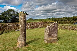
Trethevy Quoit is a well-preserved megalithic structure between St Cleer and Darite in Cornwall, England, United Kingdom. It is known locally as "the giant's house". Standing 9 feet (2.7 m) high, it consists of five standing stones capped by a large slab and was added to the Heritage at Risk Register in 2017.
Laneast is a village and civil parish in Cornwall, England, United Kingdom. It lies above the River Inny valley, about six miles (11 km) west of Launceston. The population in the 2001 census was 164, increasing to 209 at the 2011 census.
Poldark Mine is a tourist attraction near the town of Helston in Cornwall, England, UK. It lies within the Wendron Mining District of the Cornwall and West Devon Mining Landscape World Heritage Site. Its features include underground guided tours through ancient tin mine workings; a museum of industrial heritage, mining equipment and Cornish social history; and a scheduled ancient monument and riverside gardens.

Donyarth or Dungarth was the last recorded king of Cornwall. He was probably an under-king, paying tribute to the West Saxons.

St Cleer is a civil parish and village in east Cornwall, England, United Kingdom. The village is situated on the southeast flank of Bodmin Moor approximately two miles (3 km) north of Liskeard. The population of the parish in 2001 numbered 3257. This includes Common Moor and had increased to 3,297 at the 2011 census. An electoral ward also exists. The population at the 2011 census is 4,366.

East Pool mine, was a metalliferous mine in the Camborne and Redruth mining area, just east of the village of Pool in Cornwall. Worked from the early 18th century until 1945, first for copper and later tin, it was very profitable for much of its life. Today the site has two preserved beam engines and is part of the Cornwall and West Devon Mining Landscape World Heritage Site. It is owned by the National Trust.

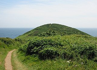
Cornish promontory forts, commonly known in Cornwall as cliff castles, are coastal equivalents of the hill forts and Cornish "rounds" found on Cornish hilltops and slopes. Similar coastal forts are found on the north–west European seaboard, in Normandy, Brittany and around the coastlines of the British Isles, especially in Wales, Scotland and Ireland. Many are known in southwest England, particularly in Cornwall and its neighbouring county, Devon. Two have been identified immediately west of Cornwall, in the Isles of Scilly.

Stapleford Cross is an Anglo-Saxon high cross dating from the eleventh century, now located in the churchyard of St. Helen's Church, Stapleford, in Nottinghamshire, England.

The Butter Cross in Dunster within the English county of Somerset is a Grade II* listed building and scheduled monument. The cross was originally erected in the late 14th or early 15th century in the main street, and was moved to its current site in the late 18th or early 19th century. Although the head of the cross is missing, the shaft and socket stone are original. The cross is in the care of English Heritage and is managed by the National Trust.
The Cornwall Heritage Trust (CHT) is an organisation which owns and manages historic sites in Cornwall, England. It was founded in 1985. It works in close cooperation with Natural England, Historic England and English Heritage.
Black Head is a headland at the western end of St Austell Bay, in Cornwall, England. It is owned by the National Trust.