King Salmon River (Ugashik River tributary)

Last updated
King Salmon River
Relief map of USA Alaska.png
Red pog.svg
Location of the mouth of the King Salmon River in Alaska
Location
Country United States
State Alaska
Borough Lake and Peninsula
Physical characteristics
Source Mother Goose Lake
 - location Alaska Peninsula National Wildlife Refuge
 - coordinates 57°13′02″N157°22′59″W / 57.21722°N 157.38306°W / 57.21722; -157.38306 [1]
 - elevation76 ft (23 m) [2]
River mouth Ugashik River
 - location7 miles (11 km) south of Bristol Bay and 8 miles (13 km) southwest of Ugashik, Alaska Peninsula
 - coordinates 57°29′50″N157°38′30″W / 57.49722°N 157.64167°W / 57.49722; -157.64167 Coordinates: 57°29′50″N157°38′30″W / 57.49722°N 157.64167°W / 57.49722; -157.64167 [1]
 - elevation0 ft (0 m) [1]
Length35 mi (56 km) [1]

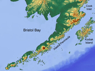
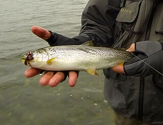
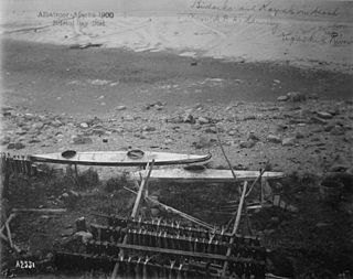
The King Salmon River is a 35-mile (56 km) tributary of the Ugashik River in the U.S. state of Alaska. [1] Beginning at Mother Goose Lake in the Aleutian Range, it flows northwest to meet the larger river near the upper reaches of Ugashik Bay. [3] The lake and the upper course of the King Salmon lie within the Alaska Peninsula National Wildlife Refuge. [3] The river's gravel bottom and braided channels are ideal for the many king salmon that spawn in its waters, but they limit navigation to small skiff.

Ugashik River watercourse

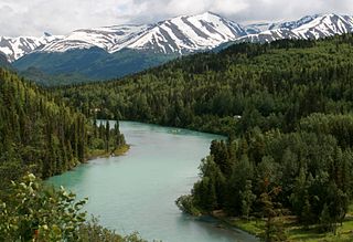
The Ugashik River is a stream, 43 miles (69 km) long, on the Alaska Peninsula of the U.S. state of Alaska. It flows from headwaters near Lower Ugashik Lake and empties into Ugashik Bay, an estuary of the Bering Sea's Bristol Bay.

U.S. state constituent political entity of the United States

In the United States, a state is a constituent political entity, of which there are currently 50. Bound together in a political union, each state holds governmental jurisdiction over a separate and defined geographic territory and shares its sovereignty with the federal government. Due to this shared sovereignty, Americans are citizens both of the federal republic and of the state in which they reside. State citizenship and residency are flexible, and no government approval is required to move between states, except for persons restricted by certain types of court orders. Four states use the term commonwealth rather than state in their full official names.

Alaska State of the United States of America

Alaska is a U.S. state in the northwest extremity of North America, just across the Bering Strait from Asia. The Canadian province of British Columbia and territory of Yukon border the state to the east and southeast. Its most extreme western part is Attu Island, and it has a maritime border with Russia to the west across the Bering Strait. To the north are the Chukchi and Beaufort seas—southern parts of the Arctic Ocean. The Pacific Ocean lies to the south and southwest. It is the largest U.S. state by area and the seventh largest subnational division in the world. In addition, it is the 3rd least populous and the most sparsely populated of the 50 United States; nevertheless, it is by far the most populous territory located mostly north of the 60th parallel in North America: its population—estimated at 738,432 by the United States Census Bureau in 2015— is more than quadruple the combined populations of Northern Canada and Greenland. Approximately half of Alaska's residents live within the Anchorage metropolitan area. Alaska's economy is dominated by the fishing, natural gas, and oil industries, resources which it has in abundance. Military bases and tourism are also a significant part of the economy.

There are many rivers in Alaska bearing the name King Salmon River, including tributaries to the Egegik River and Nushagak River systems in southwest Alaska, alone. The name is also occasionally confused with a nickname given the Kenai River, a popular fishing stream located in the Cook Inlet drainage of southcentral Alaska.

Egegik River river in Alaska, United States

The Egegik River is a waterway in the U.S. state of Alaska. A biological survey was conducted at the base of the Alaska Peninsula in 1902 by Wilfred Hudson Osgood, which included the Egegik River.

Nushagak River river in the United States of America

The Nushagak River is a river in southwest Alaska, United States. It begins in the Alaska Range and flows southwest 450 km (280 mi) to Nushagak Bay, an inlet of Bristol Bay, east of Dillingham, Alaska.

Kenai River river in the United States of America

The Kenai River called Kahtnu in the Dena'ina language, is the longest river in the Kenai Peninsula of south central Alaska. It runs 82 miles (132 km) westward from Kenai Lake in the Kenai Mountains, through the Kenai National Wildlife Refuge and Skilak Lake to its outlet into the Cook Inlet of the Pacific Ocean near Kenai and Soldotna.

Besides the large numbers of king salmon, the river also hosts large numbers of sea-run Dolly Varden, Chum Salmon and a small run of Pink Salmon.

Dolly Varden trout species of fish

The Dolly Varden trout is a species of salmonid native to cold-water tributaries of the Pacific Ocean in Asia and North America. It is in the genus Salvelinus of true chars, which includes 51 recognized species, the most prominent being the brook, lake and bull trout, as well as Arctic char. Although many populations are semi-anadromous, fluvial and lacustrine populations occur throughout its range. It is considered by taxonomists as part of the Salvelinus alpinus or Arctic char complex, as many populations of bull trout, Dolly Varden trout and Arctic char overlap.

See also

Related Research Articles

Yukon River river in the Yukon territory of Canada

The Yukon River is a major watercourse of northwestern North America. The river's source is in British Columbia, Canada, from which it flows through the Canadian Yukon Territory. The lower half of the river lies in the U.S. state of Alaska. The river is 3,190 kilometres (1,980 mi) long and empties into the Bering Sea at the Yukon–Kuskokwim Delta. The average flow is 6,430 m3/s (227,000 ft3/s). The total drainage area is 832,700 km2 (321,500 mi2), of which 323,800 km2 (126,300 mi2) is in Canada. The total area is more than 25% larger than Texas or Alberta.

Kenai Peninsula peninsula

The Kenai Peninsula is a large peninsula jutting from the coast of Southcentral Alaska. The name Kenai is derived from the word "Kenaitze" or "Kenaitze Indian Tribe", the name of the Native Athabascan Alaskan tribe, the Kahtnuht’ana Dena’ina, that historically inhabited the area. They called the Kenai Peninsula Yaghanen.

White River (Washington) river in Washington state, United States

The White River is a white, glacial river in the U.S. state of Washington. It flows about 75 miles (121 km) from its source, the Emmons Glacier on Mount Rainier, to join the Puyallup River at Sumner. It defines part of the boundary between King and Pierce counties.

Alaska Peninsula peninsula extending about 800 km (497 mi) to the southwest from the mainland of Alaska and ending in the Aleutian Islands

The Alaska Peninsula is a peninsula extending about 800 km (497 mi) to the southwest from the mainland of Alaska and ending in the Aleutian Islands. The peninsula separates the Pacific Ocean from Bristol Bay, an arm of the Bering Sea.

Bristol Bay easternmost arm of the Bering Sea, at 57° to 59° North 157° to 162° West in Southwest Alaska; 400 km long, 290 km, wide at its mouth; rivers flowing into it include the Cinder, Egegik, Igushik, Kvichak, Meshik, Nushagak, Naknek, Togiak, and Ugashik

Bristol Bay is the eastern-most arm of the Bering Sea, at 57° to 59° North 157° to 162° West in Southwest Alaska. Bristol Bay is 400 km (250 mi) long and 290 km, (180 mi) wide at its mouth. A number of rivers flow into the bay, including the Cinder, Egegik, Igushik, Kvichak, Meshik, Nushagak, Naknek, Togiak, and Ugashik.

Alagnak River river in Alaska

The Alagnak River is a 64-mile (103 km) tributary of the Kvichak River in the U.S. state of Alaska. It has a catchment area of approximately 1400 square mi (3600 km2). It is located in central Lake and Peninsula Borough.

Mulchatna River watercourse

The Mulchatna River is a 160-mile (260 km) tributary of the Nushagak River in the U.S. state of Alaska. Beginning at Turquoise Lake, it flows generally southwest to meet the larger river 65 miles (105 km) northeast of Dillingham. The Mulchatna's mouth is slightly south (downstream) of the village of Koliganek on the Nushagak, which continues southwest to Nushagak Bay, an arm of Bristol Bay.

Dago Creek

Dago Creek is a stream, 50 miles (80 km) long, on the Alaska Peninsula in the U.S. state of Alaska. Beginning in a small lake 16 miles (26 km) southeast of Egegik, it meanders southwest across the flats to enter Ugashik Bay 3 miles (5 km) southeast of Smoky Point.

Ugashik Lakes lake

The Ugashik Lakes are two adjacent lakes along the Ugashik River on the Alaska Peninsula in the U.S. state of Alaska.

Mother Goose Lake is a 6.4 mile long lake located at head of King Salmon River, on the Alaska Peninsula, 21 miles south of Ugashik, Aleutian Range. It was named in 1923 by R. H. Sargent, USGS, as "suggested by its goose-like shape." According to Sargent, the local name was King gautham giri Lake. The lake lies entirely within the Alaska Peninsula National Wildlife Refuge.

Southwest Alaska

Southwest Alaska is a region of the U.S. state of Alaska. The area is not exactly defined by any governmental administrative region(s); nor does it always have a clear geographic boundary.

Salcha River river in the United States of America

The Salcha River is a 125-mile (201 km) tributary of the Tanana River in the U.S. state of Alaska. Rising in the eastern part of the Fairbanks North Star Borough east of Fort Wainwright, it flows generally west-southwest to meet the larger river at Aurora Lodge, 33 miles (53 km) southeast of Fairbanks.

Coastal cutthroat trout subspecies of fish

The coastal cutthroat trout also known as the sea-run cutthroat trout, or harvest trout is one of the several subspecies of cutthroat trout found in Western North America. The coastal cutthroat trout occurs in four distinct forms. A semi-anadromous or sea-run form is the most well known. Freshwater forms occur in both large and small rivers and streams and lake environments. The native range of the coastal cutthroat trout extends south from the southern coastline of the Kenai Peninsula in Alaska to the Eel River in Northern California. Coastal cutthroat trout are resident in tributary streams and rivers of the Pacific basin and are rarely found more than 100 miles (160 km) from the ocean.

Dog Salmon River river in the United States of America

The Dog Salmon River is a 70-mile (110 km) tributary of the Ugashik River in the U.S. state of Alaska. Beginning on the flanks of Mount Kialagvik, it flows northwest through the Alaska Peninsula National Wildlife Refuge to meet the larger river 4 miles (6 km) southwest of Ugashik, at the head of Ugashik Bay, an arm of Bristol Bay.

King Salmon River (Nushagak River tributary) river in the United States of America

The King Salmon River is a 45-mile (72 km) tributary of the Nushagak River in southwest Alaska, United States. It flows eastward from headwaters 60°17′06″N158°28′33″W at a small unnamed lake in the Taylor Mountains to its confluence with the larger river about 220 miles (354 km) north of Nushagak Bay.

Becharof National Wildlife Refuge

Becharof National Wildlife Refuge is a National Wildlife Refuge in the Aleutian Range of the Alaska Peninsula of southwestern Alaska. It is adjacent to Katmai National Park and Preserve. This national wildlife refuge, which covers an area of 1,200,000 acres (4,900 km2), was established in 1980 to conserve major brown bears, salmon, migratory birds, caribou, marine birds, and mammals and to comply with treaty obligations. It lies primarily in the east-central part of Lake and Peninsula Borough, but extends eastward into the mainland portion of Kodiak Island Borough. The refuge is administered from offices in King Salmon.

References

  1. 1 2 3 4 5 "King Salmon River". Geographic Names Information System. United States Geological Survey. March 31, 1981. Retrieved December 1, 2013.
  2. Derived by entering source coordinates in Google Earth.
  3. 1 2 Alaska Atlas & Gazetteer (7th ed.). Yarmouth, Maine: DeLorme. 2010. p. 41. ISBN   978-0-89933-289-5.