Arthabaska Regional County Municipality is a regional county municipality located in the Centre-du-Québec region of Quebec. Its seat is Victoriaville.

Rivière-du-Loup is a small city on the south shore of the Saint Lawrence River in Quebec. The city is the seat for the Rivière-du-Loup Regional County Municipality and the judicial district of Kamouraska.

Bécancour is a regional county municipality in the Centre-du-Québec region of Quebec, Canada. Its seat is Bécancour.

Brome-Missisquoi is a regional county municipality in the Eastern Townships region of Quebec, Canada. Its seat is Cowansville.
La Haute-Gaspésie is a regional county municipality in the Gaspésie–Îles-de-la-Madeleine region of eastern Quebec, Canada, on the Gaspé peninsula. The regional county municipality seat is in Sainte-Anne-des-Monts.

Marguerite-D'Youville is a regional county municipality located in the Montérégie region of southwestern Quebec, Canada. The seat is in Verchères.

La Rivière-du-Nord is a regional county municipality in the Laurentides region of Quebec, Canada. The seat is in Saint-Jérôme. It is named for the river that runs through it, the Rivière du Nord.

La Vallée-du-Richelieu(The Valley of the Richelieu) is a regional county municipality in the Montérégie region in southwestern Quebec, Canada. Its seat is McMasterville.

Témiscamingue is a regional county municipality in the Abitibi-Témiscamingue region of western Quebec, Canada. The county seat is Ville-Marie.
Témiscouata is a regional county municipality in the Bas-Saint-Laurent region of Quebec, Canada. It is located southeast of Rivière-du-Loup, bordering New Brunswick, and is centred on Lake Témiscouata. Its seat is Témiscouata-sur-le-Lac.

Cascades is a Canadian company that produces, converts, and markets packaging and tissue products composed mainly of recycled fibres. Cascades employs more than 11,000 people in more than 100 operating units in North America and Europe. It was founded in 1964.
Montmagny is a city in the Montmagny Regional County Municipality within the Chaudière-Appalaches region of Quebec. It is the county seat. Its population as of the Canada 2011 Census was 11,491.

Route 243 is a north/south highway on the south shore of the Saint Lawrence River. Its northern terminus is in Saint-Félix-de-Kingsey at the junction of Route 255 and its southern terminus is in the township of Potton where it crosses the Canada–US border at the North Troy-Highwater Border Crossing into Vermont and becomes Vermont Route 243. Route 243 is not a busy highway as it does not go through big towns.
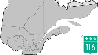
Route 116 is an east/west highway on the south shore of the Saint Lawrence River in Quebec, Canada. Until the mid-1970s it was known as Route 9. Its eastern terminus is in Lévis at the junction of Route 132, and the western terminus is at the junction of Route 134 in Lemoyne part of a concurrency with Route 112 until Saint-Hubert just south of the Saint-Hubert Municipal Airport. The stretch between Lévis and Plessisville does not have much traffic, since Autoroute 20 is not that far from the highway. Between Plessisville and Richmond traffic is heavier as it passes bigger towns, and it is further away from Autoroute 20. From Richmond to Autoroute 20, it is quiet again, before reaching Saint-Hyacinthe, where it becomes a busy four-lane separated highway, going through the growing "South Shore" suburbs of Montreal. From the junction of Autoroute 30 to its western terminus, it is a controlled-access Autoroute-grade expressway. This portion was once envisioned to be part of Autoroute 16. An unofficial extension of Route 116 as thought of by locals, from the western terminus follows the Route 134 limited access expressway to the Jacques Cartier Bridge.
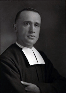
Brother Marie-Victorin, F.S.C., was a Canadian member of Brothers of the Christian Schools and a noted botanist in Quebec, Canada. He is known as the father of the Botanical Garden of Montreal.

East Hereford is a municipality of about 300 people in southeastern Quebec, Canada, in Coaticook Regional County Municipality in the Estrie region.

Grenville is a village municipality in the Argenteuil Regional County Municipality of the Laurentides region of Quebec, Canada. It is located opposite Hawkesbury, Ontario, on the Ottawa River.
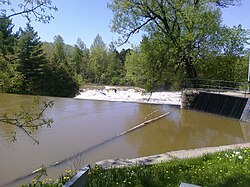
Saint-Félix-de-Kingsey is a Quebec municipality located in the Drummond Regional County Municipality in the Centre-du-Quebec region. The population as of the Canada 2011 Census was 1,563. The municipality was known as the Township of Kingsey until 1999.

Whitworth is an Indian reserve in the Bas-Saint-Laurent region of Quebec. It is geographically located within the territory of Rivière-du-Loup Regional County Municipality but is not legally part of it. Its population was 0 in the Canada 2006 Census and it appears to have been left out of the Canada 2011 Census.