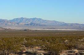
Inyo County is a county in the eastern central part of the U.S. state of California, located between the Sierra Nevada and the state of Nevada. In the 2020 census, the population was 19,016. The county seat is Independence. Inyo County is on the east side of the Sierra Nevada and southeast of Yosemite National Park in Central California. It contains the Owens River Valley; it is flanked to the west by the Sierra Nevada and to the east by the White Mountains and the Inyo Mountains. With an area of 10,192 square miles (26,400 km2), Inyo is the second-largest county by area in California, after San Bernardino County. Almost half of that area is within Death Valley National Park. However, with a population density of 1.8 people per square mile, it also has the second-lowest population density in California, after Alpine County.

Steens Mountain is a large fault-block mountain in the northwest United States, located in Harney County, Oregon. Stretching some fifty miles (80 km) north to south, on its west side it rises from the Alvord Desert at an elevation of about 4,200 feet (1,280 m) to 9,738 feet (2,968 m) at the summit. Steens Mountain is not part of a mountain range but is properly a single mountain, the largest of Oregon's fault-block mountains.

The Chocolate Mountains of California are located in Imperial and Riverside counties in the Colorado Desert of Southern California. The mountains stretch more than 60 miles (100 km) in a northwest to southeast direction, and are located east of the Salton Sea and south and west of the Chuckwalla Mountains and the Colorado River. To the northwest lie the Orocopia Mountains.

The Dead Mountains are a mountain range in the southeastern Mojave Desert, in San Bernardino County, California. The range borders the tri-state intersection of Nevada, Arizona and California, and the Mohave Valley, with the Fort Mojave Indian Reservation bordering the range foothills on the east and northeast, in the three states.
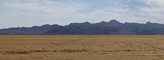
The Big Maria Mountains are located in the southeastern part of the U.S. state of California, near the Colorado River and Arizona. The range lies between Blythe and Vidal, and west of U.S. Route 95 in California and east of Midland. The mountains are home to the Eagle Nest Mine and reach an elevation of 1,030 m (3,380 ft). A power line that runs from Parker Dam to Yuma, Arizona runs through the range. A smaller range, the Little Maria Mountains, lie to the west of the Big Marias.

The Little Picacho Wilderness is a 38,214-acre (15,465 ha) wilderness area under the jurisdiction of the Bureau of Land Management. The wilderness is found in a southeast extension of the Chocolate Mountains adjacent to the Colorado River, in the southeastern part of California. It should not be confused with the Picacho Peak Wilderness which is located to the northeast.

The Whipple Mountains are located in eastern San Bernardino County, California. They are directly west of the Colorado River, Parker Dam, and Lake Havasu; south of Needles, California; north of Parker, Arizona and Vidal, California; and northeast of Vidal Junction, California.

The Nopah Range is a mountain range located in Inyo County, California, United States, near the eastern border with Nevada.

The Bigelow Cholla Garden Wilderness is in the eastern Mojave Desert and within Mojave Trails National Monument, located in San Bernardino County, California.

Pilot Peak is the highest mountain in the Pilot Range in extreme eastern Elko County, Nevada, United States. It is the most topographically prominent peak in Elko County and the fourth-most prominent peak in Nevada. The peak is on public land administered by the Bureau of Land Management and thus has no access restrictions.
The Jackson Mountains are a north-northeast trending mountain range in southwestern Humboldt County, Nevada. The range is flanked on the west by the Black Rock Desert and the Black Rock Range beyond. To the north across the Quinn River and Nevada State Route 140 lie the Bilk Creek Mountains. To the northeast across Kings River Valley is the Double Mountains and to the east are the Sleeping Hills. To the southeast and south lie the Eugene and Kamma Mountains. The ghost town of Sulphur lies just southwest of the pass between the Jackson and Kamma ranges. Nevada State Route 49 and the Union Pacific railroad Feather River Route traverse this pass.
The Sylvania Mountains Wilderness is a federally designated wilderness area located 30 miles (48 km) east of Bishop in the state of California. The wilderness is 18,677acres in size and is managed by the Bureau of Land Management (BLM). The California Desert Protection Act of 1994 created the Sylvania Mountains Wilderness and was added to the National Wilderness Preservation System. The wilderness is bordered by Nevada stateline on the east, Piper Mountain Wilderness on the west and Death Valley National Park to the south.

The Riverside Mountains are a mountain range in Riverside County, California. The town of Vidal, California is located in the West Riverside Mountains.

The Pueblo Mountains are a remote mountain range in the United States located mostly in southeastern Oregon and partially in northwestern Nevada. The highest point in the range is Pueblo Mountain. The dominant vegetation throughout is grasses and big sagebrush; however, there are meadows with cottonwood, aspen, and willow groves along some stream drainages. Most of the range is public land administered by the Bureau of Land Management. There is very little human development in the Pueblo Mountains, and most visitors come for backpacking cross-country, camping, and hunting.
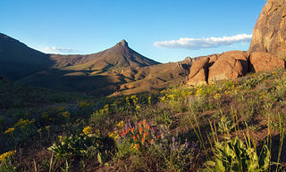
The Trout Creek Mountains are a remote, semi-arid Great Basin mountain range mostly in southeastern Oregon and partially in northern Nevada in the United States. The range's highest point is Orevada View Benchmark, 8,506 feet (2,593 m) above sea level, in Nevada. Disaster Peak, elevation 7,781 feet (2,372 m), is another prominent summit in the Nevada portion of the mountains.

The Santa Rosa Wilderness is a 72,259-acre (292.42 km2) wilderness area in Southern California, in the Santa Rosa Mountains of Riverside and San Diego counties, California. It is in the Colorado Desert section of the Sonoran Desert, above the Coachella Valley and Lower Colorado River Valley regions in a Peninsular Range, between La Quinta to the north and Anza Borrego Desert State Park to the south. The United States Congress established the wilderness in 1984 with the passage of the California Wilderness Act, managed by both the US Forest Service and the Bureau of Land Management. In 2009, the Omnibus Public Land Management Act was signed into law which added more than 2,000 acres (8.1 km2). Most of the Santa Rosa Wilderness is within the Santa Rosa and San Jacinto Mountains National Monument.

Coso Peak is the highest summit in the Coso Range, a small mountain range east of the Sierra Nevada, in Inyo County in the U.S. state of California. The peak has an elevation of 8,157 feet and a topographic prominence of 2,489 ft (759 m), making it the 88th most prominent mountain in California.
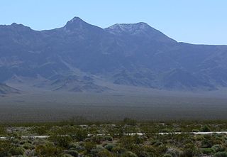
Nopah Peak is the highest named mountain in the Nopah Range, a mountain range in Inyo County, California, in the Mojave Desert just west of the state border with Nevada. The peak has an elevation of 6,365 feet and a topographic prominence of 628 ft (191 m). It boasts steep escarpments to both east and west, rising more than 3,000 ft (914 m) in approximately 0.75 miles from the desert floor of Chicago Valley to the west and a drop-off almost as steep to the east.

Meeker Peak is an 8,768-foot elevation (2,672 m) mountain summit located in Lincoln County, Nevada, United States.
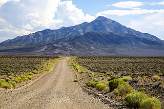
Worthington Peak is an 8,968-foot elevation (2,733 m) mountain summit located in Lincoln County, Nevada, United States.
