
Baguio, officially the City of Baguio, is a 1st class highly-urbanized city in the mountainous area of the Northern Luzon, Philippines. It is known as the Summer Capital of the Philippines, owing to its cool climate since the city is located approximately 4,810 feet above mean sea level, often cited as 1,540 meters in the Luzon tropical pine forests ecoregion, which also makes it conducive for the growth of mossy plants, orchids and pine trees, to which it attributes its other moniker as the "City of Pines".
A hairpin turn, named for its resemblance to a hairpin/bobby pin, is a bend in a road with a very acute inner angle, making it necessary for an oncoming vehicle to turn about 180° to continue on the road. Such turns in ramps and trails may be called switchbacks in American English, by analogy with switchback railways. In British English "switchback" is more likely to refer to a heavily undulating road—a use extended from the rollercoaster and the other type of switchback railway.

Session Road is a six-lane 1.7-kilometer (1.1 mi) major road in Baguio, Philippines. The road forms part of the National Route 231 (N231) of the Philippine highway network.

Burnham Park, officially known as the Burnham Park Reservation, is a historic urban park located in downtown Baguio, Philippines. It was designed by American architect and Baguio city planner, Daniel Burnham who is also the namesake of the park.

SM City Baguio is an enclosed shopping mall located at the former Pines Hotel in the City of Baguio in the Philippines. At a floor area of 160,000 m2 (1,700,000 sq ft), it is the largest shopping mall in the whole North Luzon Region. The entire complex stands on a land area of 80,000 m2 (860,000 sq ft) on Luneta Hill on top of Session Road overlooking historic Burnham Park and opposite Baguio's City Hall which is situated on a northern hill.

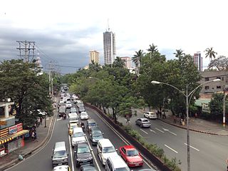
Roxas Boulevard is a popular waterfront promenade in Metro Manila in the Philippines. The boulevard, which runs along the shores of Manila Bay, is well known for its sunsets and stretch of coconut trees. The divided roadway has become a trademark of Philippine tourism, famed for its yacht club, hotels, restaurants, commercial buildings and parks. Originally called Cavite Boulevard, it was renamed Dewey Boulevard in honor of the American Admiral George Dewey, whose forces defeated the Spanish navy in the Battle of Manila Bay in 1898. The boulevard was again renamed to Heiwa Boulevard in late 1941 during Japanese Home Rule and Roxas Boulevard in the 1960s to honor President Manuel Roxas, the fifth president of the Republic of Philippines.

Baguio Cemetery is a 94,800-square-meter (23.4-acre) cemetery in the city of Baguio, Philippines, on top of a hill along Naguilian Road.

The MacArthur Highway, officially the Manila North Road (MNR), is a 500-kilometer (310 mi), two-to-six lane, national primary highway in Luzon, Philippines, it connects Caloocan in Metro Manila to the Laoag City in Ilocos Norte. It is the second longest road in the Philippines, after Maharlika Highway.

Halsema Highway is a national secondary highway in the Philippines. Situated within the Cordillera Central range in northern Luzon, it stretches from the city limit of Baguio to the municipality of Bontoc. Its highest point is at 7,400 feet (2,300 m) above sea level in the municipality of Atok. It was officially recognized as the highest altitude highway in the Philippines until 2019 when the 2,428.66 m (7,968.0 ft) high point Kiangan–Tinoc–Buguias Road in Tinoc, Ifugao was recognized as the new holder of the distinction.

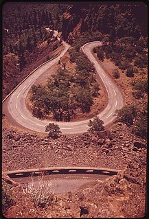
The Lions Head is a statue along Kennon Road, a major highway in Luzon, Philippines, that leads to the city of Baguio. Located in Camp 6, the Lion's Head measures 40 ft (12 m) in height. It was conceptualized by the Lions Club members of Baguio, during the term of Luis Lardizabal as mayor of Baguio from 1969 to 1970 and as the club's president, to become the club's symbol or imprint in the area. Prior to the artistic sculpting, the limestone was prepared by a group of engineers and miners, then the "actual artistic carving of the façade" was rendered by Anselmo Bayang Day-ag, an Ifugao artist/sculptor from the Cordillera Administrative Region. The construction project began in 1968 but was interrupted. The project was continued in 1971 by another Lions Club president, Robert Webber, and was unveiled in 1972.

Kalaw Avenue is a short stretch of road in the Ermita district of Manila, Philippines. It forms the southern boundary of Rizal Park running east–west from San Marcelino Street to Roxas Boulevard near the center of the city. It begins as a four-lane road at the intersection with San Marcelino widening to an eight-lane divided roadway along the stretch of Rizal Park from Taft Avenue west to Roxas Boulevard. It has a short extension into the reclaimed area of Luneta and Quirino Grandstand as South Drive. The avenue's segment from Taft Avenue to Roxas Boulevard is assigned as National Route 155 (N155) of the Philippine highway network.
President Elpidio Quirino Avenue, more commonly known as Quirino Avenue, is a 6-10 lane divided highway in Manila, Philippines. It runs for 3.6 kilometers in a northeast-southwest direction from Nagtahan Bridge across from Santa Mesa in the north to Roxas Boulevard in Malate in the south. It passes through Paco and Pandacan districts where it also serves as a truck route between Port Area and South Luzon Expressway. North of Nagtahan Bridge, the road continues as Lacson Avenue. It is designated as part of Circumferential Road 2.

The Aspiras–Palispis Highway is a Philippine major highway in northern Luzon that runs from the city of Baguio to the municipality of Agoo in the province of La Union.
The Hyatt Terraces Baguio was a 12-storey hotel in Baguio, Philippines. It sustained the most serious damage compared to other buildings in Baguio following the 1990 Luzon earthquake, when the hotel's terraced front wing collapsed and fell into the lobby area killing at least 50 people.

The Baguio Athletic Bowl is a sports complex within the grounds of Burnham Park in Baguio, Philippines. Completed in 1945, it is currently undergoing renovation work.
The Governor Pack Road is a major highway in Baguio, Philippines, named for the American William F. Pack, who was appointed Military Governor of Benguet on November 15, 1901 and served as the civilian Governor of Mountain Province from 1909 to 1915.
Legarda Road is a major road in Baguio in the Philippines that connects from Aspiras-Palispis Highway to Yandoc Street and Urbano Street.
The Loakan Road is a 6.2-kilometer (3.9 mi), major road in Baguio, Philippines. It provides access to Loakan Airport located in the outskirts of the city. It is designated as a component of National Route 231 (N231) of the Philippine highway network.
Amparo Heights Road is a major road in Baguio in the Philippines that connects from Kennon Road to Bakakeng Sur Road.

The Pugo–Rosario Road is a major road in La Union that connects from MacArthur Highway in Rosario to the Aspiras–Palispis Highway in Pugo. It is the alternative route to Marcos Highway for motorists going to Pugo and Baguio.