Budapest is the capital and most populous city of Hungary. It is the ninth-largest city in the European Union by population within city limits and the largest city on the Danube river; the city has an estimated population of 1,752,286 over a land area of about 525 square kilometres. Budapest, which is both a city and county, forms the centre of the Budapest metropolitan area, which has an area of 7,626 square kilometres and a population of 3,303,786. It is a primate city, constituting 33% of the population of Hungary.

The Tisza, Tysa or Tisa, is one of the major rivers of Central and Eastern Europe. It was once called "the most Hungarian river" because it flowed entirely within the Kingdom of Hungary. Today, it crosses several national borders.

Pest is the eastern, mostly flat part of Budapest, Hungary, comprising about two-thirds of the city's territory. It is separated from Buda and Óbuda, the western parts of Budapest, by the Danube River. Among its most notable sights are the Inner City, the Hungarian Parliament Building, Heroes' Square and Andrássy Avenue.

Komárno, colloquially also called Révkomárom, Öregkomárom, Észak-Komárom in Hungarian, is a town in Slovakia at the confluence of the Danube and the Váh rivers. Historically it was formed by the "old town" on the left bank of Danube, present day Komárno in Slovakia, and by a "new town" on the right bank, present day Komárom in Hungary, which were historically one administrative unit. Following World War I and the Treaty of Trianon, the border of the newly created Czechoslovakia cut the historical, unified town in half, creating two new independent towns in two countries. Komárno and Komárom are connected by the Elisabeth Bridge, which used to be an official border crossing between Slovakia and Hungary until border checks were lifted due to the Schengen Area rules. In 2020, a new road bridge was opened.

Komárom county was an administrative county (comitatus) of the Kingdom of Hungary, situated on both sides of the Danube river. Today, the territory to the north of the Danube is part of Slovakia, while the territory to the south of the Danube is part of Hungary.
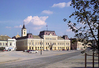
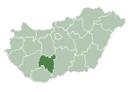
Baja is a city with county rights in Bács-Kiskun County, southern Hungary. It is the second largest city in the county, after the county seat at Kecskemét, and is home to some 35,000 people. Baja is the seat of the Baja municipality.

The Danube Swabians is a collective term for the ethnic German-speaking population who lived in Kingdom of Hungary of east-central Europe, especially in the Danube River valley, first in the 12th century, and in greater numbers in the 17th and 18th centuries. Most were descended from earlier 18th-century Swabian settlers from Upper Swabia, the Swabian Jura, northern Lake Constance, the upper Danube, the Swabian-Franconian Forest, the Southern Black Forest and the Principality of Fürstenberg, followed by Hessians, Bavarians, Franconians and Lorrainers recruited by Austria to repopulate the area and restore agriculture after the expulsion of the Ottoman Empire. They were able to keep their language and religion and initially developed strongly German communities in the region with German folklore.

Mohács is a town in Baranya County, Hungary, on the right bank of the Danube.

The Hungarian Parliament Building, also known as the Parliament of Budapest after its location, is the seat of the National Assembly of Hungary, a notable landmark of Hungary, and a popular tourist destination in Budapest. It is situated on Kossuth Square in the Pest side of the city, on the eastern bank of the Danube. It was designed by Hungarian architect Imre Steindl in neo-Gothic style and opened in 1902. It has been the largest building in Hungary since its completion.
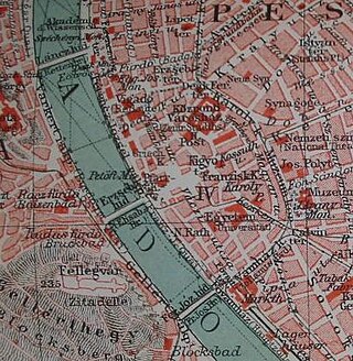
The Danube Promenade is located on the Pest side of Budapest, Hungary. The promenade itself lies on the left bank of the Danube, extending from the Széchenyi Chain Bridge to the Erzsébet Bridge.

The Shoes on the Danube Bank is a memorial erected on 16 April 2005, in Budapest, Hungary. Conceived by film director Can Togay, he created it on the east bank of the Danube River with sculptor Gyula Pauer to honour the Jews who were massacred by fascist Hungarian militia belonging to the Arrow Cross Party in Budapest during the Second World War. They were ordered to take off their shoes, and were shot at the edge of the water so that their bodies fell into the river and were carried away. The memorial represents their shoes left behind on the bank.

Babarc is a village and municipality in Baranya county, Hungary. Until the end of World War II, the inhabitants were Danube Swabians, also called locally as Stifolder, because their ancestors were from Fulda (district). Most of the former German settlers were expelled to Germany and Austria in 1945–1948, as a result of the Potsdam Agreement. Only a few Germans of Hungary live there, the majority today are the descendants of Hungarians from the Czechoslovak–Hungarian population exchange. They occupied the houses of the former Danube Swabian inhabitants.
Beremend is a village in Baranya County, Hungary on the Croatian border, it constitutes the southernmost point of the country. Residents are Magyars, with minority of Serbs. Until the end of World War II, the inhabitants were Danube Swabians, also referred to locally as Stifolder, because their ancestors arrived in the 17th and 18th centuries from Fulda (district). Most of the former German settlers were expelled to Allied-occupied Germany and Allied-occupied Austria in 1945–1948, consequent to the Potsdam Agreement. Only a few Germans of Hungary live there, the majority today are the descendants of Hungarians from the Czechoslovak–Hungarian population exchange. They got the houses of the former Danube Swabian inhabitants.
Dunaszekcső is a village in Baranya County, Hungary, situated on the right bank of the River Danube. The inhabitants are ethnic Hungarian, with minorities of Danube Swabians and Serbs. The population was about 1900 in 2015.

The Danube is the second-longest river in Europe, after the Volga in Russia. It flows through much of Central and Southeastern Europe, from the Black Forest south into the Black Sea. A large and historically important river, it was once a frontier of the Roman Empire. In the 21st century, it connects ten European countries, running through their territories or marking a border. Originating in Germany, the Danube flows southeast for 2,850 km (1,770 mi), passing through or bordering Austria, Slovakia, Hungary, Croatia, Serbia, Romania, Bulgaria, Moldova, and Ukraine. Among the many cities on the river are four national capitals: Vienna, Bratislava, Budapest, and Belgrade. Its drainage basin amounts to 817,000 km² and extends into nine more countries.

Kisbudmér is a village and municipality in Baranya county, Hungary.

The Danube Palace is a Neo-Baroque concert hall located in the Inner City of Budapest, Hungary. It was built between 1883 and 1885 according to the plans of Vilmos Freund. It was known as the casino of Lipótváros – not in the sense of gambling - but an aristocratic club for entertainment. The Palace served as a place of culture, supporting many young artists. Bartók, Kodály, and Dvorák all played in its first-class concert hall. Since 1951 the building has been carrying out the cultural programs of the Ministry of Internal Affairs. It is home to the Danube Symphony Orchestra.

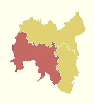
Bonyhád is a district in southern part of Tolna County. Bonyhád is also the name of the town where the district seat is found. The district is located in the Southern Transdanubia Statistical Region.
The 2nd constituency of Tolna County is one of the single member constituencies of the National Assembly, the national legislature of Hungary. The constituency standard abbreviation: Tolna 02. OEVK.