Kit Hill

Last updated

Kit Hill
Kit Hill Top.jpg
The ornate mine chimney, now clad in a range of transmitters and aerials, on top of Kit Hill.
Highest point
Elevation 334 m (1,096 ft)
Prominence 171 m (561 ft)
Parent peak None
Listing Marilyn
Geography
Location Cornwall, United Kingdom
OS grid SX375713
Topo map OS Landranger 201

Kit Hill (Cornish : Bre Skowl), [1] at 334 metres high, dominates the area between Callington and the River Tamar in southeast Cornwall, England, UK. The word 'Kit' comes from Old English for kite, a reference to birds of prey (and not specifically the red kite). Buzzards and sparrowhawks can still be seen on the hill. It is one of five Marilyn hills in Cornwall, the four others are Watch Croft, Brown Willy, Carnmenellis and Hensbarrow Beacon.

Contents

Geography

Kit Hill Country Park (which includes the hill and surrounding areas), was given to the people of Cornwall in 1985 to mark the birth of Prince William, by his father, the Duke of Cornwall (Prince Charles). [2] It is managed by Cornwall Council, [3] and consists of some 400 acres (152 hectares), making it the most dominant landscape feature in East Cornwall. [2] Kit Hill is the highest point in the Tamar Valley Area of Outstanding Natural Beauty.

The hill was formed in the same way as nearby Bodmin Moor by the intrusion of magma into overlying sedimentary rocks. This caused the formation of many mineral deposits that were mined extensively in the 18th and early 19th centuries.

As the highest point of Hingston Down, Kit Hill is probably the best viewpoint in the southeast of Cornwall,[ according to whom? ] with views of the Tamar valley, Dartmoor and Bodmin Moor. Kit Hill Country Park has a high wildlife population including deer and badgers, rabbits, rare moths and butterflies.[ citation needed ]

On the summit of Kit Hill is an artificial fort (a Civil War redoubt) [3] and a folly built by Sir John Call of Whiteford, Stoke Climsland, built in the style of a low-walled Saxon castle.

History

The Anglo-Saxon Chronicle reports that in 835 (corrected by scholars to 838 AD) Egbert king of the West Saxons defeated an army of Vikings and Cornish at Hengestdun = "Stallion Hill", which is usually interpreted as being at Hingston Down. [4]

Other notable artifacts on Kit Hill include Neolithic and Bronze Age barrows. The area around these is maintained by a ranger and volunteers, who also generally keep the vegetation on the hill under control.

Mining

The Country Park is steeped in mining history. Metals extracted included tin, silver, copper and tungsten.
The main mines were:

Atomic Energy Authority

In 1877 a company called Kit Hill Tunnel Ltd began work on both the south and north sides of the hill to create a tunnel which would be 2 miles (3.2 km) long. The southern portal was at Silver Hill, and that at the north was near a small mine called Excelsior. However, due to the toughness of the underlying bedrock, progress was costly and slow, and ceased about a year later. In 1881 a new company named Kit Hill Great Consols took over the setts of Kit Hill United and Excelsior mine. They deepened the North Engine Shaft to 112 fathoms and lengthened the tunnel running south to meet it. However, this too was proving too costly, and wound up in 1885, before it was half-way complete. Several later attempts were made to extend the Excelsior Tunnel, but by 1938, it was still only 2,400 feet (730 m) long.

However, in 1959 the Atomic Energy Authority took over operations, and used the tunnel for underground explosions. [5] The activities were part of Operation Orpheus, and the Kit Hill events were the first part:

Railways

Construction of The Tamar, Kit Hill & Callington Railway started in 1864. The name was later changed to the East Cornwall Mineral Railway, and the line opened in 1872. Seven and a half miles long, it ran from Calstock's river frontage, past Kelly Quay & Drakewalls and the Gunnislake quarries, along the northern flank of Hingston Down to below Kit Hill at Kelly Bray, where an inclined tramway connected with it. It amalgamated with the Plymouth, Devonport and South Western Junction Railway crossing the Tamar above Calstock and onto the junction at Bere Alston.

The Gunnislake to Bere Alston section still survives as part of the Tamar Valley Line.

Some remnants, mainly the granite blocks, of the line can be found on the northern slopes of the Country Park site.

Related Research Articles

River Tamar River in southwest England

The Tamar is a river in south west England, that forms most of the border between Devon and Cornwall. A part of the Tamar valley is a World Heritage Site due to its historic mining activities.

Callington Human settlement in England

Callington is a civil parish and town in east Cornwall, England, United Kingdom about 7 miles (11 km) north of Saltash and 9 miles (14 km) south of Launceston.

Tamar Valley Line Railway line in Devon and Cornwall, England

The Tamar Valley Line is a railway line from Plymouth, Devon, to Gunnislake, Cornwall, in England, also known as the Gunnislake branch line. The line follows the River Tamar for much of its route. Like all railway lines in Devon and Cornwall, it is unelectrified and all trains are diesel powered. The entire line is single track past St. Budeaux Junction.

Bere Alston Human settlement in England

Bere Alston is a village in West Devon in the county of Devon in England. It forms part of the civil parish of Bere Ferrers.

Kelly Bray Human settlement in England

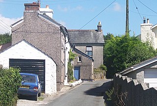
Kelly Bray is a village in east Cornwall, England, United Kingdom. It is situated one mile (1.6 km) north of Callington, immediately west of Kit Hill in a former mining area. Kelly Bray is in the parish of Callington and lies within the St Dominick, Harrowbarrow and Kelly Bray division on Cornwall Council. The population was 3,949 at the 2011 census. Kelly Bray is first recorded ca. 1286 as Kellibregh.

Plymouth, Devonport and South Western Junction Railway Former English railway company

The Plymouth, Devonport and South Western Junction Railway (PD&SWJR) was an English railway company. It constructed a main line railway between Lydford and Devonport, in Devon, England, enabling the London and South Western Railway (LSWR) to reach Plymouth more conveniently than before.

Calstock Village & Parish in England

Calstock is a civil parish and a large village in south east Cornwall, England, United Kingdom, on the border with Devon. The village is situated on the River Tamar 6 miles (9.7 km) south west of Tavistock and 10 miles (16 km) north of Plymouth.

Bere Alston railway station Railway station in Devon, England

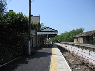
Bere Alston railway station serves the village of Bere Alston in Devon, England, 10+14 miles (16.5 km) north of Plymouth on the Tamar Valley Line to Gunnislake.

Mining in Cornwall and Devon Mining in the English counties of Cornwall and Devon

Mining in Cornwall and Devon, in the southwest of England, began in the early Bronze Age, around 2150 BC. Tin, and later copper, were the most commonly extracted metals. Some tin mining continued long after the mining of other metals had become unprofitable, but ended in the late 20th century. In 2021, it was announced that a new mine was extracting battery-grade lithium carbonate, more than 20 years after the closure of the last South Crofty tin mine in Cornwall in 1998.

Calstock railway station Railway station in Cornwall, England

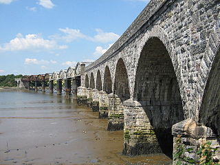
Calstock railway station is an unstaffed railway station on the Tamar Valley Line serving the village of Calstock in Cornwall, United Kingdom. It is situated at the north end of Calstock Viaduct which carries the railway at high level over the River Tamar.

Gunnislake railway station Railway station in Cornwall, England

Gunnislake railway station serves the village of Gunnislake in Cornwall, England. There are also connecting buses from here to the town of Tavistock. However the station is located in or nearer to the villages of Drakewalls and Albaston. It is the northern terminus of the Tamar Valley Line from Plymouth.

Hingston Down

Hingston Down is a hill not far from Gunnislake in Cornwall, England, United Kingdom. It is the subject of an old rhyme, due to the prolific tin mining that formerly took place in the area:

Hingston Down well ywrought
Is worth London Town dearly bought.

Gunnislake Human settlement in England

Gunnislake is a large village in east Cornwall, England, United Kingdom. It is situated in the Tamar Valley approximately ten miles (16 km) north of Plymouth

The East Cornwall Mineral Railway was a 1,067 mm gauge railway line, opened in 1872 to connect mines and quarries in the Callington and Gunnislake areas in east Cornwall with shipping at Calstock on the River Tamar. The line included a rope-worked incline to descend to the quay at Calstock.

Cornish Main Line Railway line in Cornwall, England

The Cornish Main Line is a railway line in Cornwall and Devon in the United Kingdom. It runs from Penzance to Plymouth, crossing from Cornwall into Devon over the famous Royal Albert Bridge at Saltash.

Callington railway station Disused railway station in Cornwall, England

Callington railway station was a railway station in the village of Kelly Bray, one mile (1.6 km) north of the centre of the small town of Callington, Cornwall. It was the terminus of a branch line from Bere Alston, built by the Plymouth, Devonport and South Western Junction Railway, but operated by the London and South Western Railway. The station closed in 1966. The Tamar Valley Line still operates services from Bere Alston, with services terminating at Gunnislake railway station, 5 miles (8 km) to the east of Callington.

Albaston Human settlement in England

Albaston is a hamlet in Cornwall, England, United Kingdom. It is in the civil parish of Calstock. It is located at Ordnance Survey grid reference SX 423 704.

Norris Green, Cornwall Human settlement in England

Norris Green is a village in Cornwall, England, UK. It was enlarged from a farming hamlet so that it now adjoins the neighbouring village of Higher Metherell. Both settlements are within the civil parish of Calstock which borders the River Tamar, the county boundary with Devon in south-east Cornwall.
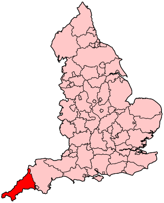
Presented below is an alphabetical index of articles related to Cornwall:

Danescombe Quay Quayside in Cornwall

Danescombe Quay was the largest and last quayside on the River Tamar to be used commercially, capable of berthing large steam steel cargo ships of up to 120 feet. It is located on the Cornish bank of the river, half a mile out of the town of Calstock and next to Cotehele House the ancient seat of the Earl of Mount Edgcumbe, now a National Trust property. The Quayside lies within the Tamar Valley AONB and is part of a UNESCO World Heritage Site.

References

  1. Place-names in the Standard Written Form (SWF) Archived 2013-05-15 at the Wayback Machine  : List of place-names agreed by the MAGA Signage Panel Archived 2013-05-15 at the Wayback Machine . Cornish Language Partnership.
  2. 1 2 "Kit Hill". Cornwall Council. Retrieved 6 February 2013.
  3. 1 2 Exploring Cornish Mines - Vol. 4. ISBN   1-873443-36-6
  4. See, for example: Payton, Philip (2004). Cornwall: A History (2nd ed.). Fowey: Cornwall Editions Ltd. p. 68. ISBN   1-904880-00-2.
  5. Barton, Denys Bradford (1964) The Mines & Mineral Railways of East Cornwall & West Devon. Truro: D. Bradford Barton Ltd. ISBN   0-85153-034-6

Coordinates: 50°31′08″N4°17′37″W / 50.51887°N 4.29360°W / 50.51887; -4.29360